
Hot More Humid Severe Weather Risk Evening
Hot More Humid Severe Weather Risk Evening
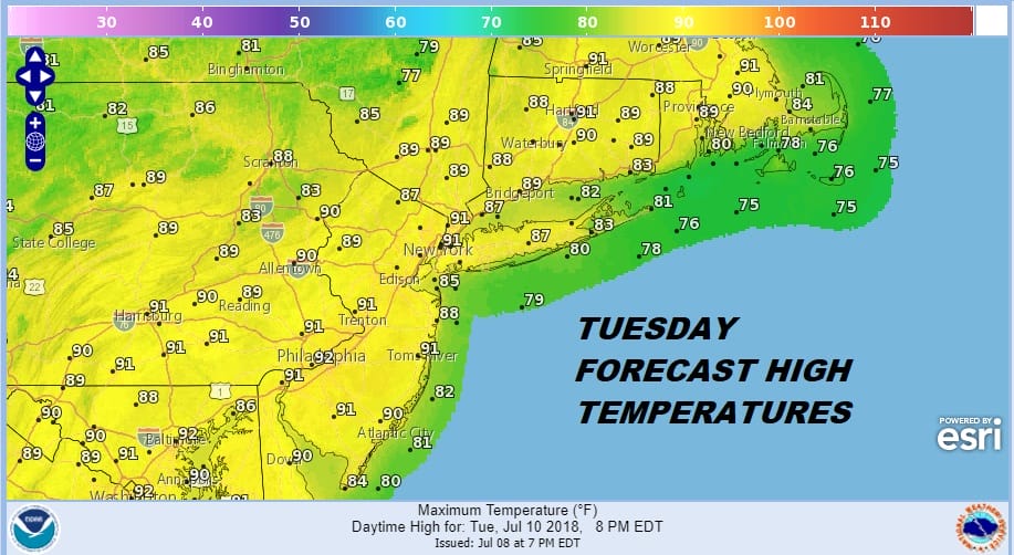
Today is going to be the one hot day this week and you can feel it outside with the strong July sun. Humidity levels will be the highest they have been since last Friday however the levels of the humidity are no where near what they were last week so it will feel slightly uncomfortable but not as bad. Temperatures are heading for the upper 80s and lower 90s this afternoon and of course it will be a little bit cooler at the shore.
We do have a cold front approaching from the northwest however there isn’t much cloud cover with it at the moment as the satellite loop shows. It is likely to me mostly sunny into the afternoon with some clouds probably developing late in the day.
EASTERN SATELLITE

REGIONAL RADAR

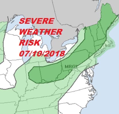
As far as thunderstorms go even though parts of the area are indicated to be at a marginal risk for severe weather this evening, it is likely that the thunderstorms will be scattered in nature and not everyone will see one. Once the front passes another shot of dry air comes in for the next 2 days with some sunshine for both Wednesday and Thursday. Humidity will be reasonable and highs both days will be in the 80s.
Friday and into the weekend we will begin to see an increase in humidity and temperatures will skew higher, setting us up for a rather warm and humid weekend. However we don’t see extreme heat returning. Temperatures over the weekend will likely be in the mid 80s to near 90 in some spots but they shouldn’t be much higher than that. There is the chance for some scattered thunderstorms Saturday evening as a weak disturbance moves through and there could be some scattered thunderstorms on Sunday as well but much of the time it will be rain free.
CHRIS LIKELY TO BECOME A HURRICANE LATER TODAY
As far as Tropical Storm Chris is concerned it is likely to become a hurricane later today and begin moving northeast offshore. The impact here will be at the beaches with rip currents and rough seas developing later today and continue into at least Thursday before settling down. If you are headed to shore locations bear this in mind and swim cautiously. Pay attention to life guards and any red flags that are up for unsafe conditions.
Please note that with regards to any tropical storms or hurricanes, should a storm be threatening, please consult your local National Weather Service office or your local government officials about what action you should be taking to protect life and property.
 GET JOE A CIGAR IF YOU LIKE

LATEST JOESTRADAMUS ON THE LONG RANGE


