
Hermine Strengthening This Evening
Hermine Strengthening This Evening
New GFS Model On Track
Reports from a NOAA plane this evening indicate that Hermine is strengthening. The plane reported a max flight level wind of 55 knots which translates probably to a 50 to 55 mph surface wind. The pressure has dropped to 1001 millibars. Hermine is likely to strengthen further over the next 24 hours
URNT12 KWBC 312342
VORTEX DATA MESSAGE  AL092016
A. 31/23:12:48Z
B. 25 deg 16 min N
  087 deg 10 min W
C. 850 mb 1443 m
D. 15 kt
E. 234 deg 14 nm
F. 307 deg 12 kt
G. 227 deg 11 nm
H. 1001 mb
I. 20 C / 1546 m
J. 22 C / 1545 m
K. 16 C / NA
L. NA
M. NA
N. 12345 / 8
O. .01 / 4 nm
P. NOAA3 1009A CYCLONE OB 40
MAX OUTBOUND AND MAX FL WIND 55 KT 087 / 28 NM 23:20:25Z
MAX OUTBOUND SFC WIND 52 KT 088 / 15 NM 23:17:10Z
CNTR DROPSONDE SFC WIND 125 / 08 KTS
CONVECTION SE OF CENTER


..HERMINE STRENGTHENS SOME WHILE IT HEADS TOWARD THE FLORIDA GULF
COAST...


SUMMARY OF 700 PM CDT...0000 UTC...INFORMATION
----------------------------------------------
LOCATION...25.5N 87.4W
ABOUT 330 MI...535 KM SSW OF APALACHICOLA FLORIDA
ABOUT 330 MI...535 KM SW OF TAMPA FLORIDA
MAXIMUM SUSTAINED WINDS...50 MPH...85 KM/H
PRESENT MOVEMENT...NNE OR 30 DEGREES AT 8 MPH...13 KM/H
MINIMUM CENTRAL PRESSURE...1001 MB...29.56 INCHES


WATCHES AND WARNINGS
--------------------
CHANGES WITH THIS ADVISORY:

None.

SUMMARY OF WATCHES AND WARNINGS IN EFFECT:

A Hurricane Watch is in effect for...
* Anclote River to Destin

A Tropical Storm Warning is in effect for...
* Anclote River to Destin

A Tropical Storm Watch is in effect for...
* Marineland Florida to Altamaha Sound Georgia

Interests along the United States east coast from Georgia through
the Carolinas should monitor the progress of this system.

For storm information specific to your area, including possible
inland watches and warnings, please monitor products issued by your
local National Weather Service forecast office.


DISCUSSION AND 48-HOUR OUTLOOK
------------------------------
At 700 PM CDT (0000 UTC), the center of Tropical Storm Hermine was
located near latitude 25.5 North, longitude 87.4 West.  Hermine is
moving toward the north-northeast near 8 mph (13 km/h), and this
motion with an increase in forward speed is expected to continue
through Thursday.  On the forecast track, the center will be near
the coast in the warning area Thursday night.

Recent reports from a NOAA Hurricane Hunter aircraft indicate that
maximum sustained winds have increased to near 50 mph (85 km/h) with
higher gusts.  Additional strengthening is forecast during the next
36 hours, and Hermine could be near hurricane strength by the time
landfall occurs.

Tropical-storm-force winds extend outward up to 125 miles (205 km)
from the center, mainly to the east and southeast.

The minimum central pressure reported by a NOAA Hurricane Hunter
aircraft is 1001 mb (29.56 inches).
The late afternoon GFS run was very similar to the previous run as it takes Hermine to Southern New Jersey from Coastal North Carolina before it begins an eastward drift. What is not known at the moment is how much energy it will derive from the upper air storm it will be involved with.
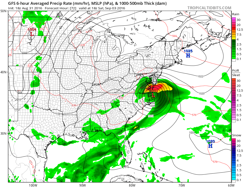
HERMINE ON GFS MODEL SATURDAY 2PM
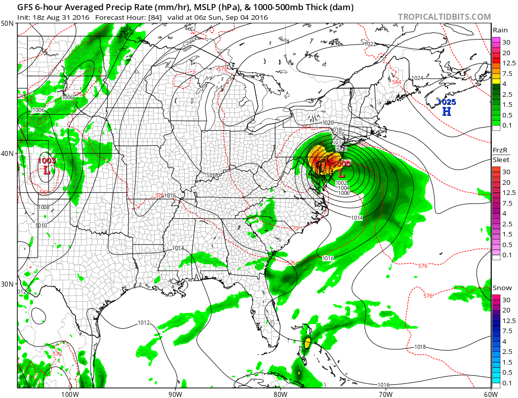
HERMINE ON GFS SUNDAY MORNING 2AM
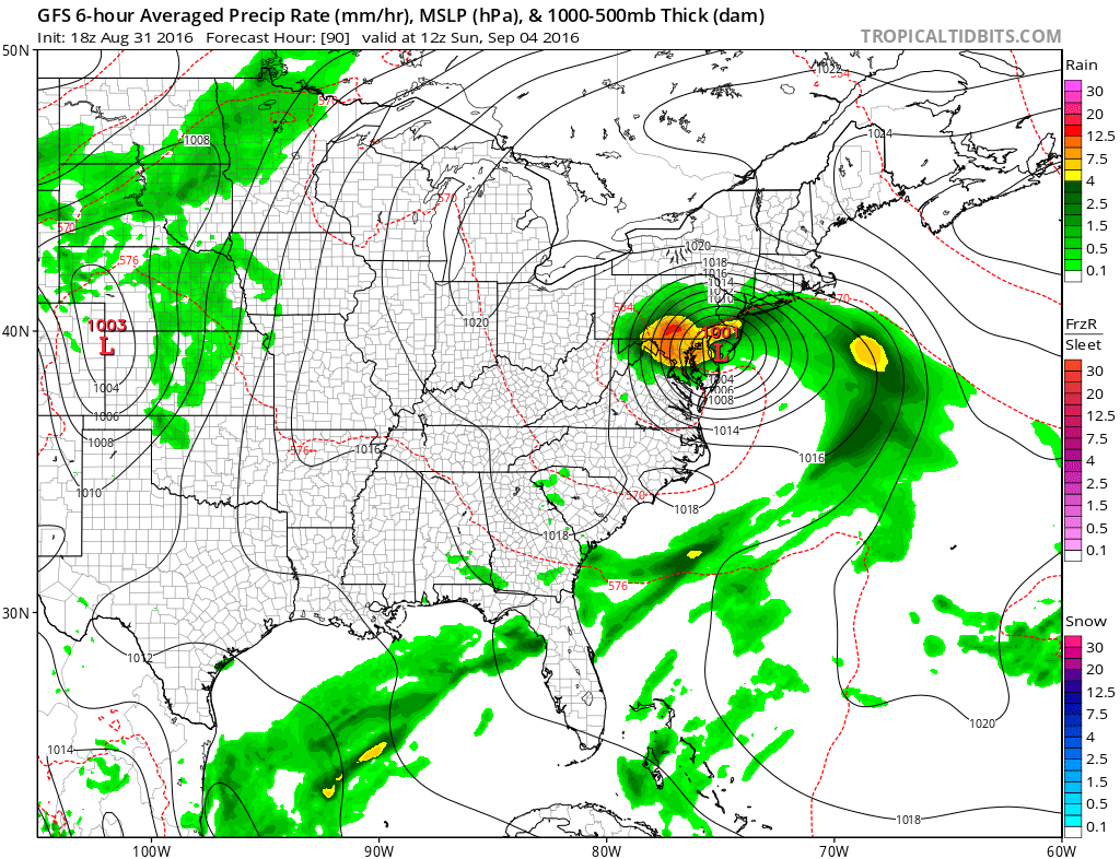
HERMINE ON GFS SUNDAY MORNING
FiOS1 News Weather Forecast For Long Island
FiOS1 News Weather Forecast For New Jersey
FiOS1 News Weather Forecast For Hudson Valley
NATIONAL WEATHER SERVICE SNOW FORECASTS
LATEST JOESTRADAMUS ON THE LONG RANGE
Weather App

Don’t be without Meteorologist Joe Cioffi’s weather app. It is really a meteorologist app because you get my forecasts and my analysis and not some automated computer generated forecast based on the GFS model. This is why your app forecast changes every 6 hours. It is model driven with no human input at all. It gives you an icon, a temperature and no insight whatsoever.
It is a complete weather app to suit your forecast needs. All the weather information you need is right on your phone. Android or I-phone, use it to keep track of all the latest weather information and forecasts. This weather app is also free of advertising so you don’t have to worry about security issues with your device. An accurate forecast and no worries that your device is being compromised.
Use it in conjunction with my website and my facebook and twitter and you have complete weather coverage of all the latest weather and the long range outlook. The website has been redone and upgraded. Its easy to use and everything is archived so you can see how well Joe does or doesn’t do when it comes to forecasts and outlooks.
Just click on the google play button or the apple store button on the sidebar for my app which is on My Weather Concierge. Download the app for free. Subscribe to my forecasts on an ad free environment for just 99 cents a month.
Get my forecasts in the palm of your hand for less than the cost of a cup of Joe!
![]()
![]()