
European Weather Model On Tropical Storm Hermine
European Weather Model On Tropical Storm Hermine
Today’s European weather model run was pretty much in line with all the global models with some slight twist to it as we move into next. However rather than focus on that possibility, I think the take away from all of this is that all the models including the European weather model and led by the NAM have caved to the west. This means the threat for tropical storm conditions exists from the Middle Atlantic states to Southern New England beginning Saturday in southern areas and then reaching NYC Saturday night and Southern New England later Saturday night. There are of course lots of questions here that need to be worked out.
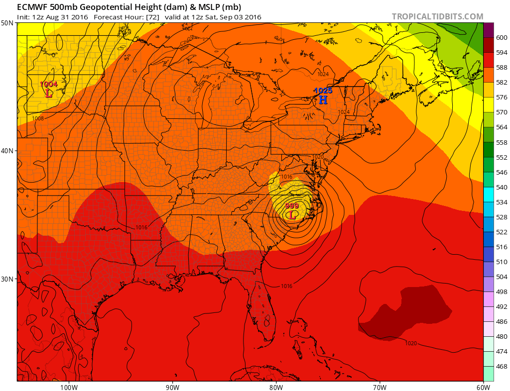
European Weather Model Saturday 8am
European Weather Model Sunday 8am
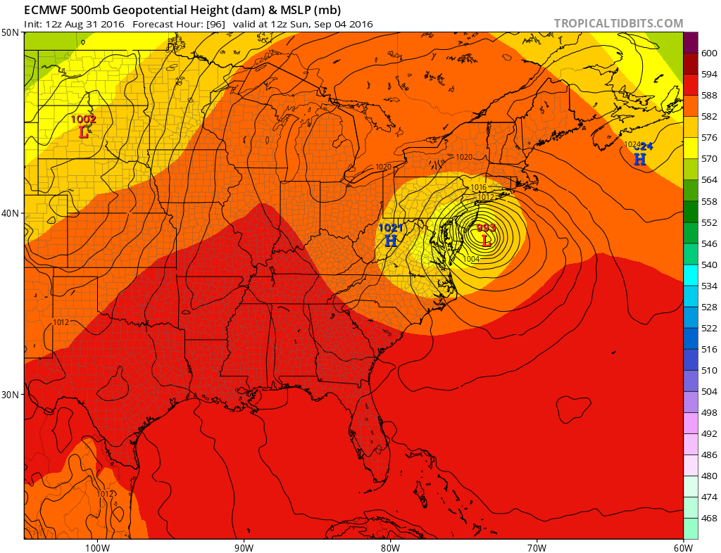
The European weather model takes the more coastal track of all the models showing Tropical Storm Hermine just southeast of Atlantic City Sunday morning. The forecast gets very tricky after that because of the big ridge in Eastern Canada. Hermine will only be able to get so far north when it will hit that block. That will cause it to drift east and then southeast. The European gets very imaginative with this by taking it southwest to near the Carolina Coast over the course of 3 days and has it as a hurricane off the Virginia coast later next week!
European Weather Model Thursday September 8th
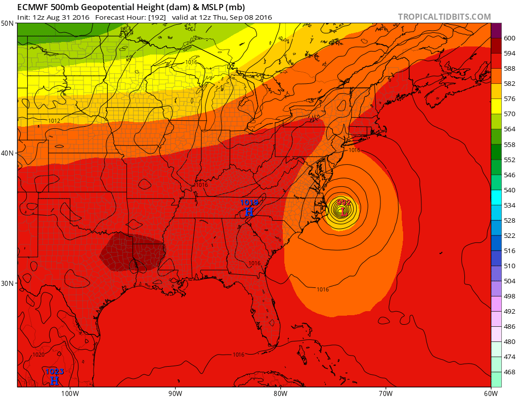
Now given the squirrelliness of the European weather model lately this solution is a little unusual. If this were to happen it would create serious tidal flooding concerns for the coast. However we won’t worry about this unless a track like this becomes something realistic.
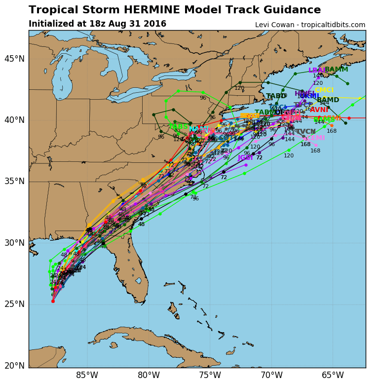
Even the latest hurricane model spaghetti models area coming up with all sorts of solutions regarding Hermine. Track will ultimately determine strength since I do believe this will be at tropical storm strength and not hurricane strength when it reaches our latitude.
FOR THE LATEST ON THE GFS MODEL HERE IS MY JOESTRADAMUS POST
JOESTRADAMUS ALSO HAS THE LATEST ON THE NAM MODEL EARLIER TODAY
HERE IS MY WEATHER VIDEO FROM THIS MORNING.

MENTION JOE CIOFFI AND GET A 5% DISCOUNT
FiOS1 News Weather Forecast For Long Island
FiOS1 News Weather Forecast For New Jersey
FiOS1 News Weather Forecast For Hudson Valley
NATIONAL WEATHER SERVICE SNOW FORECASTS
LATEST JOESTRADAMUS ON THE LONG RANGE
Weather App

Don’t be without Meteorologist Joe Cioffi’s weather app. It is really a meteorologist app because you get my forecasts and my analysis and not some automated computer generated forecast based on the GFS model. This is why your app forecast changes every 6 hours. It is model driven with no human input at all. It gives you an icon, a temperature and no insight whatsoever.
It is a complete weather app to suit your forecast needs. All the weather information you need is right on your phone. Android or I-phone, use it to keep track of all the latest weather information and forecasts. This weather app is also free of advertising so you don’t have to worry about security issues with your device. An accurate forecast and no worries that your device is being compromised.
Use it in conjunction with my website and my facebook and twitter and you have complete weather coverage of all the latest weather and the long range outlook. The website has been redone and upgraded. Its easy to use and everything is archived so you can see how well Joe does or doesn’t do when it comes to forecasts and outlooks.
Just click on the google play button or the apple store button on the sidebar for my app which is on My Weather Concierge. Download the app for free. Subscribe to my forecasts on an ad free environment for just 99 cents a month.
Get my forecasts in the palm of your hand for less than the cost of a cup of Joe!
![]()

