Tropical Storm Hermine Threat Labor Day Weekend
Tropical Storm Hermine Threat Labor Day Weekend
Hurricane Watches Florida Coastal Bend
Threat to East Coast Increases
Based on the satellite loops the tropical depression has developed a well defined circulation and has been upgraded to a tropical storm. Tropical Storm Warnings are posted for a portion of the Florida Coastal bend and a hurricane watch remains in effect for much of that area as well.
...NOAA HURRICANE HUNTERS FIND THAT THE DEPRESSION HAS
STRENGTHENED INTO A TROPICAL STORM...


SUMMARY OF 100 PM CDT...1800 UTC...INFORMATION
----------------------------------------------
LOCATION...24.7N 88.0W
ABOUT 395 MI...640 KM SSW OF APALACHICOLA FLORIDA
ABOUT 415 MI...665 KM WSW OF TAMPA FLORIDA
MAXIMUM SUSTAINED WINDS...40 MPH...65 KM/H
PRESENT MOVEMENT...N OR 10 DEGREES AT 2 MPH...4 KM/H
MINIMUM CENTRAL PRESSURE...1000 MB...29.53 INCHES


WATCHES AND WARNINGS
--------------------
CHANGES WITH THIS ADVISORY:

None.

SUMMARY OF WATCHES AND WARNINGS IN EFFECT:

A Hurricane Watch is in effect for...
* Anclote River to Indian Pass

A Tropical Storm Warning is in effect for...
* Anclote River to the Walton/Bay County line

A Tropical Storm Watch is in effect for...
* Marineland Florida to Altamaha Sound Georgia

A Hurricane Watch means that hurricane conditions are possible
within the watch area.  A watch is typically issued 48 hours before
the anticipated first occurrence of tropical-storm-force winds,
conditions that make outside preparations difficult or dangerous.

A Tropical Storm Warning means that tropical storm conditions are
expected somewhere within the warning area within 36 hours.

A Tropical Storm Watch means that tropical storm conditions are
possible within the watch area, generally within 48 hours.

Interests along the United States east coast from Georgia through
the Carolinas should monitor the progress of this system.

For storm information specific to your area, including possible
inland watches and warnings, please monitor products issued by your
local National Weather Service forecast office.


DISCUSSION AND 48-HOUR OUTLOOK
------------------------------
At 100 PM CDT (1800 UTC), the center of Tropical Storm Hermine was
located near latitude 24.7 North, longitude 88.0 West.  Hermine
appears to be drifting northward near 2 mph (4 km/h).  A
north-northeastward motion is expected later today, and a turn
toward the northeast with increasing forward speed is expected on
Thursday.  On the forecast track, the center of Hermine will
approach the northwest Florida coast in the warning area on Thursday
afternoon.

Maximum sustained winds have increased to near 40 mph (65 km/h) with
higher gusts.  Additional strengthening is forecast during the next
day or two, and Hermine could be near hurricane strength by the time
landfall occurs.

Tropical-storm-force winds extend outward up to 105 miles (165 km)
mainly to the southeast of the center.

The estimated minimum central pressure is 1000 mb (29.53 inches).

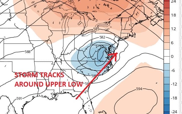
The question now for the east coast is becoming a little more clear as weather models seem to be converging on a more westerly track up the coast just inland. This means that the system could maintain a degree of tropical storm strength as it moves north northeastward. The shift west is because the tropical system has taken longer to move northward and thereby missing the trough that will be moving over the northeast. That trough would have pushed this out to the south. Instead the trough passes by and the bottom part of it cuts off from the main jet stream and lifts the tropical storm northward to our latitude. This is based on the latest GFS model and Nam model. Also other global models are on board.
TROPICAL STORM HERMINE UPPER AIR SATURDAY 2PM
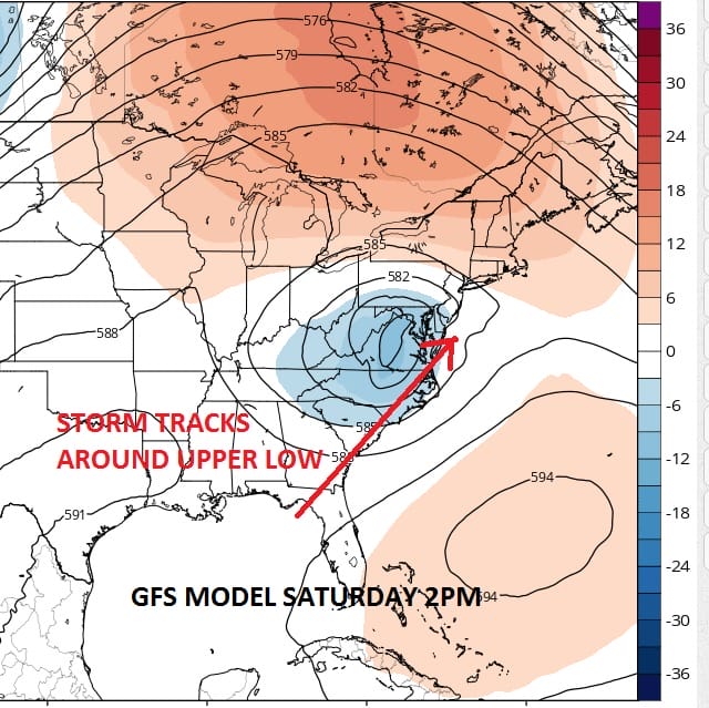
TROPICAL STORM HERMINE SURFACE SATURDAY 2PM

If this is correct weather conditions will being to deteriorate Saturday afternoon and evening with rain moving in for Saturday night and Sunday. We will have more on this later today. Let me say this and make it clear. THIS IS NOT ANOTHER SANDY. It would appear that the main threat for this would be heavy rain and it might be a drought breaking rain for some areas which will be a good thing. Details will be fine tuned.
FiOS1 News Weather Forecast For Long Island
FiOS1 News Weather Forecast For New Jersey
FiOS1 News Weather Forecast For Hudson Valley
NATIONAL WEATHER SERVICE SNOW FORECASTS
LATEST JOESTRADAMUS ON THE LONG RANGE
Weather App

Don’t be without Meteorologist Joe Cioffi’s weather app. It is really a meteorologist app because you get my forecasts and my analysis and not some automated computer generated forecast based on the GFS model. This is why your app forecast changes every 6 hours. It is model driven with no human input at all. It gives you an icon, a temperature and no insight whatsoever.
It is a complete weather app to suit your forecast needs. All the weather information you need is right on your phone. Android or I-phone, use it to keep track of all the latest weather information and forecasts. This weather app is also free of advertising so you don’t have to worry about security issues with your device. An accurate forecast and no worries that your device is being compromised.
Use it in conjunction with my website and my facebook and twitter and you have complete weather coverage of all the latest weather and the long range outlook. The website has been redone and upgraded. Its easy to use and everything is archived so you can see how well Joe does or doesn’t do when it comes to forecasts and outlooks.
Just click on the google play button or the apple store button on the sidebar for my app which is on My Weather Concierge. Download the app for free. Subscribe to my forecasts on an ad free environment for just 99 cents a month.
Get my forecasts in the palm of your hand for less than the cost of a cup of Joe!
![]()
![]()