
Henri Making Land Fall Southern New England
Heavy Rains Gusty Winds Flash Flooding

Weather in 5/Joe & Joe Weather Show Latest Podcast
Henri Making Land Fall Southern New England Heavy Rains Gusty Winds Flash Flooding
SUMMARY OF 800 AM EDT…1200 UTC…INFORMATION
———————————————-
LOCATION…40.7N 71.3W
ABOUT 40 MI…65 KM SSE OF MONTAUK POINT NEW YORK
ABOUT 75 MI…125 KM S OF PROVIDENCE RHODE ISLAND
MAXIMUM SUSTAINED WINDS…70 MPH…110 KM/H
PRESENT MOVEMENT…NNW OR 345 DEGREES AT 16 MPH…26 KM/H
MINIMUM CENTRAL PRESSURE…986 MB…29.12 INCHES
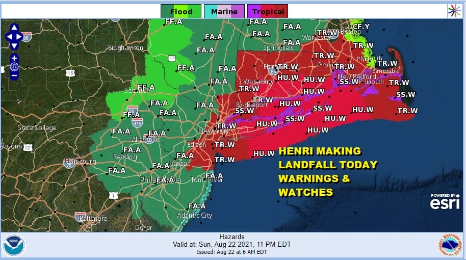
WATCHES AND WARNINGS
——————–
CHANGES WITH THIS ADVISORY:
The Hurricane Warning for Long Island, the southern coast of New
England, and Block Island has been changed to a Tropical Storm
Warning.
SUMMARY OF WATCHES AND WARNINGS IN EFFECT:
A Storm Surge Warning is in effect for…
* South shore of Long Island from Mastic Beach to Montauk Point New
York
* North shore of Long Island from Montauk Point to Flushing New York
* Flushing New York to Chatham Massachusetts
* Nantucket, Martha’s Vineyard, and Block Island
A Storm Surge Watch is in effect for…
* East Rockaway Inlet to Mastic New York
* North of Chatham Massachusetts to Sagamore Beach Massachusetts
* Cape Cod Bay
A Tropical Storm Warning is in effect for…
* Manasquan Inlet New Jersey to Chatham Massachusetts, including
Long Island and New York City
* Block Island, Nantucket and Martha’s Vineyard
Hurricane Henri has now been down graded to a tropical storm based on top winds of 70 mph as of the 7am update from the National Hurricane Center. At this point everything is underway. The storm is elongated east west reflecting the pull of the upper low in the Mid Atlantic. The worst of it from the standpoint of wind will be from now until landfall somewhere in Southeastern Connecticut or Rhode Island after a pass near the East of Long Island. I think the biggest issue with Henri will be heavy rains of several to many inches. Flash Flood Watches cover almost all of Eastern Pennsylvania, New Jersey, the Hudson Valley an much of Southern and Central New England.
SATELLITE

Bands of heavy rain and gusty winds are arcing back westward across Long Island and into New Jersey Connecticut and the Hudson Valley. Henri’s slow movement means that some places will be piling up the rain in inches. As the stronger bands arrive winds will be gusty at times though the strongest winds will be closer to the center of the storm.
WEATHER RADAR


The slowing movement of Henri will prolong rain and rack up some big totals in areas mostly to the west and well away from the actual track of the center. Several to 6 inches of rain are possible when this is all said and done and it would not surprise me at all to see some double digit amounts in some of the elevated areas in Connecticut, the Hudson Valley, and possibly even into Northern New Jersey.
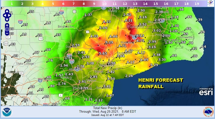
As far as the winds are concerned, the strongest winds will occur into mid afternoon. The map below shows wind gusts forecast for 12 noon which is around the time that Henri will be crossing the easternmost portion of the twin forks on Long Island. Gusty winds will extend westward back through Suffolk County in Western Nassau as well as the coasts of Connecticut and Rhode Island.

Rain and wind will last into the late afternoon and evening until the storm center moves into Connecticut and weakens. This will eventually push the arc of rain back northwestward. Be sure to tune into the Joe & Joe Weather Show at 10:30am Eastern Time for another update on Henri.
BE SURE TO DOWNLOAD THE FREE METEOROLOGIST JOE CIOFFI WEATHER APP &
ANGRY BEN’S FREE WEATHER APP “THE ANGRY WEATHERMAN!

MANY THANKS TO TROPICAL TIDBITS & F5 WEATHER FOR THE USE OF MAPS
Please note that with regards to any severe weather, tropical storms, or hurricanes, should a storm be threatening, please consult your local National Weather Service office or your local government officials about what action you should be taking to protect life and property.


