Hurricane Henri Center Closing In On Eastern Long Island
Southeast Connecticut Rhode Island
Weather in 5/Joe & Joe Weather Show Latest Podcast
Hurricane Henri Center Closing In On Eastern Long Island
Southeast Connecticut Rhode Island
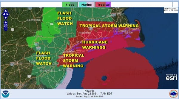
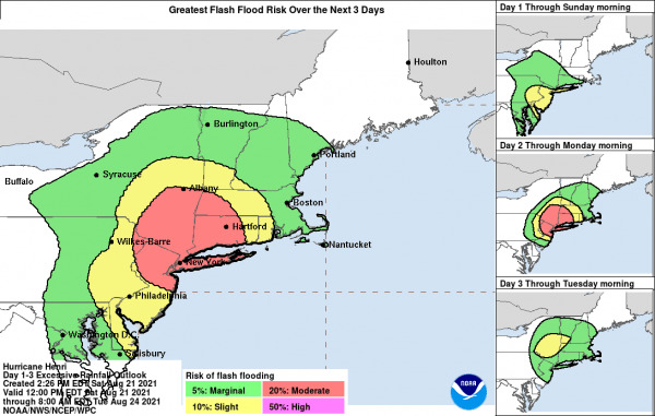
Hurricane Warnings Continue for Long Island from Fire Island Inlet east to Montauk and on the North Shore back from Montauk back to Port Jefferson. Hurricane Warnings are also up for Southeastern Connecticut to Rhode Island. Tropical Storm Warnings are up to the east out to Cape Cod and to the west back to NYC, the counties surrounding NY Harbor down to Northern Monmouth County. Flash Flood Watches are up for a large area from Northeast Pennsylvania, all of New Jersey east and northeast into New England.
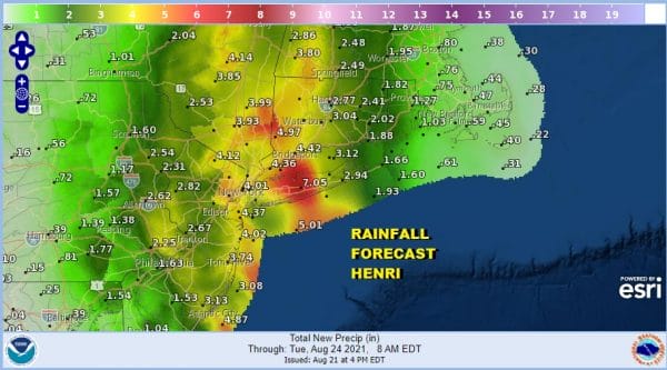
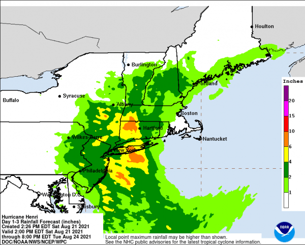
Before we get to the wind, I want to say something about the rain. I think that somebody is going to wind up with high single digits or even low double digit rainfall amounts out of this likely west of the center. The reason the Flash Flood Watch is up so far west is due to the interaction with Henri and an upper low in Virginia and Maryland that will be merging with the Henri in the flow. This will drive tropical air into the mountains north and west of the coast and potentially produce big rainfall amounts. If you are inland be on guard for flash flooding as well as river flooding.
SATELLITE
Henri strengthened today to a hurricane and we are seeing signs that strengthening may continue for a while longer. A core is forming on the right side of the center and the storm is now moving over the very warm waters of the gulf stream where water temperatures are in the mid 80s. It will peak in strength overnight and then weaken somewhat but still be a minimal hurrricane or a high end tropical storm when it reaches Eastern Long Island. Landfall should occur somewhere east of Westhampton to Montauk probably around midday.
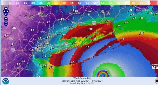
Winds will start picking up around daybreak Sunday and a little sooner as you go east. By 9am on the map above winds should be gusting 30 to 40 mph over the Eastern half of Suffolk County and 20 to 30 mph to the west. Those winds increase to their peak in the early afternoon as the center makes landfall.
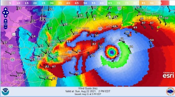
I added the wind barbs so you can see the direction of the wind at 3pm. For most of Long Island, Connecticut and back to NYC the winds will be northeast going to north and then eventually northwest. Gusts in the afternoon should reach 30 to 40 mph but to the east across Coastal Connecticut and the rest of Suffolk County gusts of 40 to 60 mph will be common and of course that circle over the South Fork west of Montauk should see gusts over 70 mph. Obviously if the center comes in further west than you can adjust everything west by the mileage distance. For now this forecast looks okay from NWS and I can’t quibble with it too much.
As far as the tidal surge goes it will be the maximum to the east. Wind direction helps out the South Shore pushing water out on the ocean front but it could push it onshore in the back bays so be cautious about this. Long Island Sound could be in a tougher spot here due to the track and a 3 to 5 ft surge is possible there at high tide. The NWS surge forecast was based on a landfall further west and i drew in my track forecast from earlier today. Im going to leave it alone just as a precaution until we are sure there is no last minute westward shift.
WEATHER RADAR
Some renegade rain showers are coming in from the southeast to the northwest on the radar this evening over Central and South Jersey. They are running ahead of Henri which is further offshore. The satellite shows Henri embedded in a wall of clouds up and down the US East Coast. The worst of all this will be during the day tomorrow. Once the storm moves inland the attention will shift to inland New Jersey, the Hudson Valley and Connecticut where very heavy rains are likely. Again as mentioned earlier I would not be at all surprised to see someone wind up with double digit rainfalls out of this. Rains and wind along the coast diminish in the late afternoon and evening but the rain continues inland into much of Sunday night.
Some rather juicy rainfall amounts are being put out by the Weather Prediction Center of 6 to 10 inches. This is not all unreasonable given the set up the upper low complicates everything with Henri and quite frankly, this is a set up that I have never seen before here in the Northern Mid Atlantic to Southern New England area so we really don’t have a prior similar experience we can fall back on. So fasten your seatbelts as Margo Channing said in All About Eve, Its going to be a bumpy Sunday!
BE SURE TO DOWNLOAD THE FREE METEOROLOGIST JOE CIOFFI WEATHER APP &
ANGRY BEN’S FREE WEATHER APP “THE ANGRY WEATHERMAN!
MANY THANKS TO TROPICAL TIDBITS & F5 WEATHER FOR THE USE OF MAPS
Please note that with regards to any severe weather, tropical storms, or hurricanes, should a storm be threatening, please consult your local National Weather Service office or your local government officials about what action you should be taking to protect life and property.


