Heavy Snow Bands Mainly In New Jersey
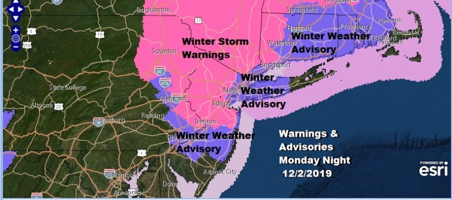
Winter Storm Warnings Winter Weather Advisories Continue

At least now we know where the heavy snow band has set up and it has been primarily north of Route 195 in New Jersey on the southern end and it cuts across Western Long Island to just north and west of Route 287 in the Hudson Valley. Now we wait to see what happens for tonight as the band and area pivot around and some areas see the precipitation fill in a bit.

The first frame here on the new NAM model is at 4pm with the last frame at 7am Tuesday. The Nam fills in the gaps on the radar and then the low begins to move northeast and strengthen off the coast of Eastern New England. From this evening into the early morning hours expect 2 to 4 inches in Northern New Jersey, the Lower Hudson Valley, NYC, and for Long Island. For areas that have seen snow today that would be 2 to 4 inches on top of the 1 to 4 inches you have gotten so far. The southern extent of this makes it a little further south of Route 195 in New Jersey before the entire area of snow pulls out between 1am and 4am on Tuesday. It might last a bit longer over Eastern Long Island and Eastern Connecticut before ending.
SATELLITE

The developing storm is interacting with the upper air storm to the southwest and it well defined on the satellite picture this evening off the New Jersey coast. It has been sitting there all day long.
REGIONAL RADAR

Regional and local radars show the banded nature of the precipitation. There were even a few thunderstorms in that cluster of yellow and red just offshore. The eastward motion has not shown up yet on the radar or on satellite loops.
LOCAL RADAR NEW YORK CITY

LOCAL RADAR PHILADELPHIA


Once the snow is done we will see genuine improvement in weather conditions on Tuesday with some sunshine and a gusty wind. Highs will be in the upper 30s to lower 40s. We will be in a chilly but mostly dry northwest flow through the end of the week with some sunshine each day and mostly below average temperatures. A cold front comes through on Friday with not much other than clouds though a little wave might develop on it as it moves out offshore. Right now we see no impact. Saturday and Sunday are shaping up to be dry and chilly as our below average temperatures continue.
BE SURE TO DOWNLOAD THE FREE METEOROLOGIST JOE CIOFFI WEATHER APP &
ANGRY BEN’S FREE WEATHER APP “THE ANGRY WEATHERMAN!
MANY THANKS TO TROPICAL TIDBITS FOR THE USE OF MAPS
Please note that with regards to any severe weather, tropical storms, or hurricanes, should a storm be threatening, please consult your local National Weather Service office or your local government officials about what action you should be taking to protect life and property.


