Heavy Showers Later Today Strong Wind Developing Later Tonight into Early Tuesday

Weather in 5/Joe & Joe Weather Show Latest Podcast
Heavy Showers Later Today Strong Wind Developing Later Tonight into Early Tuesday
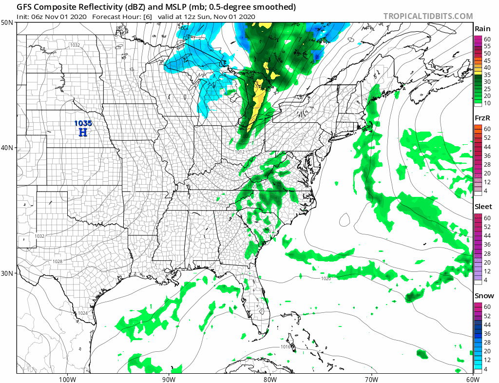
In all likelihood wind advisories or even high wind warnings will go up later today as we have a strong cold front approaching. That front will arrive later this afternoon and evening with a round of showers and some heavier downpours. The cold front is moving quickly and that will likely produce some 40 mph wind gusts ( or higher) as the front passes this evening. In the meantime clouds have rolled in and that has helped to keep temperatures up overnight and we did not revisit the sub freezing lows we saw Saturday morning.
SATELLITE

REGIONAL RADAR

Radars will be getting busy as the day wears on but especially during the afternoon as heavy showers develop virtually over head. Look for some heavy downpours and even a rumble or two of thunder can’t be ruled out. Temperatures this afternoon will be in the 50s to near 60 degrees. Showers will come to an end quickly from west to east from late afternoon through early evening.
LOCAL RADAR NEW YORK CITY

LOCAL RADAR PHILADELPHIA


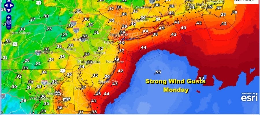
Winds will shift to the west and northwest tonight and Monday. Intensifying low pressure in the Northern New England will tighten the pressure gradient up considerable on Monday. Look for in and out clouds and sun Monday with winds gusting to 40 and possibly 50 mph.

Temperatures Monday will be in the 40s and that wind will make it feel 10 to 15 degrees colder at times. The wind will also hold temperatures up at night and that should keep us above freezing both Monday morning and Tuesday morning in most places. Only cold spots north and west of Route 84 will see temperatures bottoming in the 20s.
Early Tuesday morning a weak front goes by with a passing rain or snow shower, otherwise Tuesday will see clouds giving way to increasing sunshine and finally a decreasing wind as high pressure builds in. Highs will be in the 40s. The rest of the week will see warmer conditions develop with no rain in the forecast probably right through the weekend. Temperatures will be in the 50s Wednesday and 60s will be commonplace Thursday and Friday. We might even touch 70 in some places along the way into this weekend. Right now there doesn’t appear to be an big issue regarding a marine layer taking over and giving us cloud problems like we saw for much of the time over the last 2 weeks.
BE SURE TO DOWNLOAD THE FREE METEOROLOGIST JOE CIOFFI WEATHER APP &
ANGRY BEN’S FREE WEATHER APP “THE ANGRY WEATHERMAN!
MANY THANKS TO TROPICAL TIDBITS FOR THE USE OF MAPS
Please note that with regards to any severe weather, tropical storms, or hurricanes, should a storm be threatening, please consult your local National Weather Service office or your local government officials about what action you should be taking to protect life and property.


