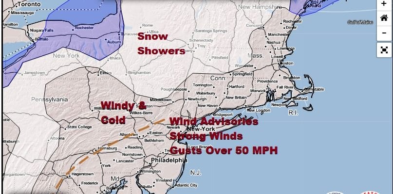
Wind Advisory Monday Gusts 50 MPH Showers End Colder Into Tuesday

Weather in 5/Joe & Joe Weather Show Latest Podcast
Wind Advisory Monday Gusts 50 MPH Showers End Colder Into Tuesday
Showers are moving through this evening as our cold front is moving through. Winds could get strong and gusty when the front passes but it is behind the front later tonight through Monday that winds will increase and become quite strong from the west northwest.

Wind Advisories are posted for the Eastern Pennsylvania, all of New Jersey, NYC, The Hudson Valley, Long Island and Connecticut for late tonight through Monday evening. We expect winds of 20 to 35 mph with gusts to 50 mph at times. The strongest winds will come around midday to mid afternoon on Monday.
SATELLITE

REGIONAL RADAR

Meanwhile we have lots of clouds around and a very active radar. Rain with some areas of heavy rain are moving to the northeast and will pass offshore. A line of heavy showers and perhaps a thunderstorm will move through this evening and then we dry out overnight with lows in the 30s to near 40.
LOCAL RADAR NEW YORK CITY

LOCAL RADAR PHILADELPHIA


Along with the wind Monday will be in and out clouds and sun. Temperatures will be going nowhere Monday with highs just in the low to mid 40s and the wind will make it feel like it is 10 to 15 degrees colder. Monday night we will be down in the 30s with 20s in cold spots. An upper air disturbance will move through early Tuesday morning with a couple of scattered rain or snow showers. Once that goes by we should see increasing amounts of sunshine Tuesday with less wind. Highs will be in the 40s though areas in South Jersey and Southern Pennsylvania southward should make it into the lower 50s.

Wednesday though at least Saturday we should see no rain. There should be some sunshine each day as long as the marine layer from off the ocean doesn’t get involved. For now we will leave that idea out of the forecast and just go for nice weather into the weekend. Wednesday highs will be in the 50s. Thursday through Saturday we should see highs in the 60s. Some inland highs could approach 70 or so while it will be closer to 60 near the shore.
BE SURE TO DOWNLOAD THE FREE METEOROLOGIST JOE CIOFFI WEATHER APP &
ANGRY BEN’S FREE WEATHER APP “THE ANGRY WEATHERMAN!
MANY THANKS TO TROPICAL TIDBITS FOR THE USE OF MAPS
Please note that with regards to any severe weather, tropical storms, or hurricanes, should a storm be threatening, please consult your local National Weather Service office or your local government officials about what action you should be taking to protect life and property.


