Heat Humidity Moving Eastward For Holiday Weekend
Heat Humidity Moving Eastward For Holiday Weekend
We can see on the satellite loop clouds moving across the Great Lakes which will mark the leading edge of heat humidity moving eastward for the holiday weekend. With July 4th on a Tuesday it makes for 4 or 5 day weekend for the creative among you. Some of those clouds over the Great Lakes will move overhead overnight and for the first part of tomorrow but they should move out by midday with sunshine and warmer temperatures to follow
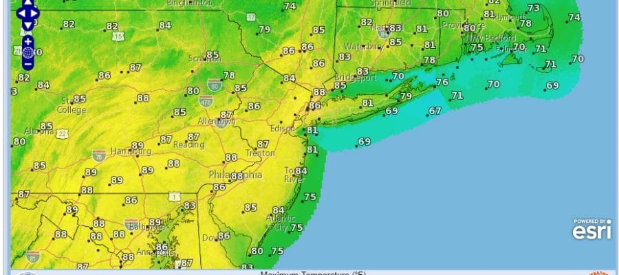
HEAT HUMIDITY MOVING EASTWARD THURSDAY FORECAST HIGHS
Most highs will reach the middle 80s Thursday. While the humidity will be a bit higher than Wednesday it will not be truly uncomfortable until Friday; at which point we should see temperatures hit 90 degrees in most areas away from the coast. Also late Friday we will introduce the chance for a scattered late day shower or thunderstorm.
SATELLITE LOOP

REGIONAL RADAR

LOCAL RADAR NEW YORK CITY

LOCAL RADAR PHILADELPHIA


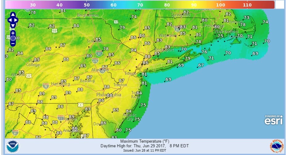
Radars locally should remain quiet through the first part of Friday so there are no issues there. Temperatures will be in the upper 80s and lower 90s Saturday with some sunshine will make the beach inviting.
HEAT HUMIDITY MOVING EASTWARD SATURDAY FORECAST HIGHS
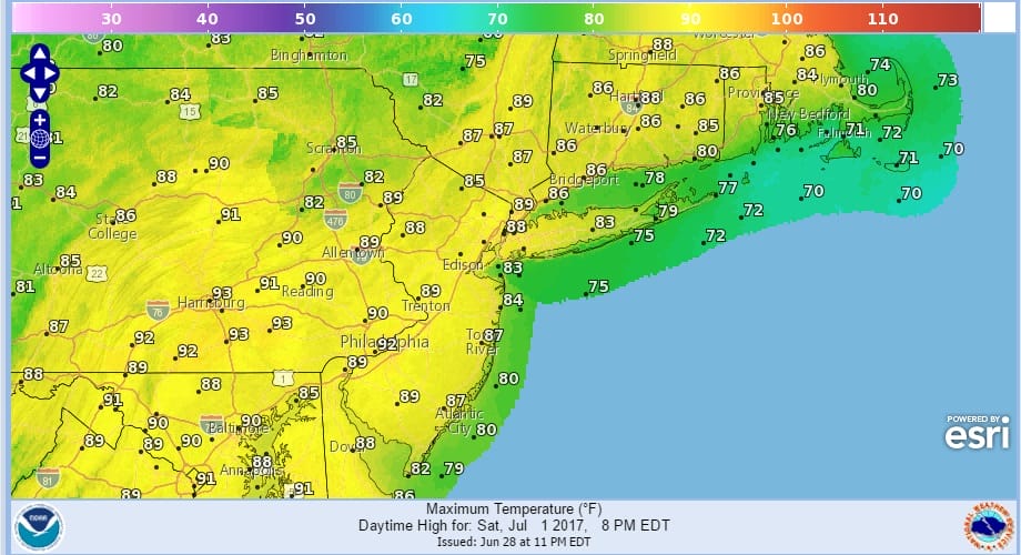
HEAT HUMIDITY MOVING EASTWARD SUNDAY FORECAST HIGHS

Sunday the issue will be more clouds and the better chance for showers and thunderstorms as a cold front approaches. Right now I would say of the two actual weekend days, Saturday will probably be the better of the two in terms of sunshine but both days will be humid and rather uncomfortable. What keeps it from getting very hot like the last two short heatwaves is more of a south southwest wind rather than a west wind. The should keep the temperatures from getting to high above the 90 degree mark.
Monday & Tuesday will still be very warm but temperatures will be in the 80s both days and dew points will be slightly lower than Friday & Saturday which would make it a shade less uncomfortable. Right now we will leave the mention of showers and thunderstorms out of the forecast for Monday and Tuesday and just go for a mix of sun and clouds. Overall the long holiday weekend will be okay to good at times with thunderstorm activity limited. Sunday will see the greatest chance for thunderstorms with the cold front.
 GET JOE A CIGAR IF YOU LIKE

Weather App

Don’t be without Meteorologist Joe Cioffi’s weather app. It is really a meteorologist app because you get my forecasts and my analysis and not some automated computer generated forecast based on the GFS model. This is why your app forecast changes every 6 hours. It is model driven with no human input at all. It gives you an icon, a temperature and no insight whatsoever.
It is a complete weather app to suit your forecast needs. All the weather information you need is right on your phone. Android or I-phone, use it to keep track of all the latest weather information and forecasts. This weather app is also free of advertising so you don’t have to worry about security issues with your device. An accurate forecast and no worries that your device is being compromised.
Use it in conjunction with my website and my facebook and twitter and you have complete weather coverage of all the latest weather and the long range outlook. The website has been redone and upgraded. Its easy to use and everything is archived so you can see how well Joe does or doesn’t do when it comes to forecasts and outlooks.
Just click on the google play button or the apple store button on the sidebar for my app which is on My Weather Concierge. Download the app for free. Subscribe to my forecasts on an ad free environment for just 99 cents a month.
Get my forecasts in the palm of your hand for less than the cost of a cup of Joe!


