Harvey Moving Back Over Gulf of Mexico
Harvey Moving Back Over Gulf of Mexico

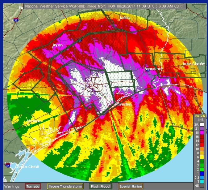
Judging from the latest radar and satellite loops, Tropical Storm Harvey is now moving back into the Gulf of Mexico. The center is about 25 or so miles northeast of Port O’Connor which puts it right on the coast. The radars this morning show that the arc of torrential rains has shifted away from the Houston Galveston area and has now moved over Eastern Texas & Southwest Louisiana. The rains continue in anad around Houston Galveston but they of lower intensity. They water however still rises there and elsewhere and more rain is forecast for the next 2 to 3 days until Harvey gets out of the way or at least far enough north to cut the tropical moisture flow off. That isnt’ happening through at least midweek.
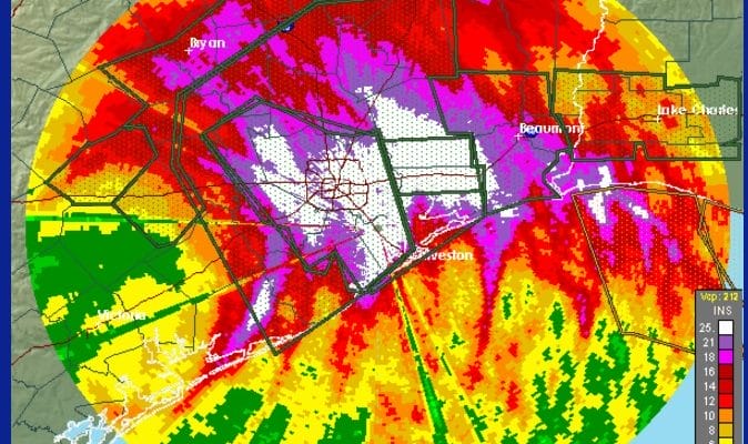
Harvey Rainfall Doppler Estimates
Doppler radar estimates of the rains from Harvey show an ever expanding area of 25 inches or more. From some official measurements they match up pretty well. So far the highest official measurement I’ve seen as 30.50 inches. These are weather spotter observations as well as from local airports and are accurate and accepted by the Weather Service as part of their data collection.
An additional 2 feet of rain is possible over the next several days as forecast by most weather models. Satellite loop shows that the center is on the coast but notice that the look of Harvey has changed from a few days ago in that Harvey no longer has a well defined core. This will probably limit strengthening once it moves completely out over the open waters of the Gulf of Mexico. Some strengthening is possible and I would not be surprised to see winds pick up a bit over the next 24 hours along the coast. Also this will bring more torrential rains to Southeast Texas over the next 48 hours.

…CENTER OF HARVEY EMERGING INTO THE GULF OF MEXICO…
…LIFE-THREATENING FLOODING CONTINUES OVER SOUTHEASTERN TEXAS…
…DO NOT ATTEMPT TO TRAVEL IN THE AFFECTED AREAS IF YOU ARE IN
A SAFE PLACE AND DO NOT DRIVE INTO FLOODED ROADWAYS…
SUMMARY OF 700 AM CDT…1200 UTC…INFORMATION
———————————————-
LOCATION…28.6N 96.1W
ABOUT 25 MI…40 KM NE OF PORT OCONNOR TEXAS
MAXIMUM SUSTAINED WINDS…40 MPH…65 KM/H
PRESENT MOVEMENT…SE OR 130 DEGREES AT 3 MPH…6 KM/H
MINIMUM CENTRAL PRESSURE…997 MB…29.44 INCHES
WATCHES AND WARNINGS
——————–
CHANGES WITH THIS ADVISORY:
None.
SUMMARY OF WATCHES AND WARNINGS IN EFFECT:
A Tropical Storm Warning is in effect for…
* Mesquite Bay to High Island
Catastrophic and life-threatening flooding continues in southeastern
Texas, and flash flood emergencies are in effect for portions of
this area. Please see warnings and other products issued by your
local National Weather Service office for additional information on
this life-threatening situation.
Interests elsewhere along the upper Texas coast and in southwestern
Louisiana should continue to monitor the progress of Harvey.
For storm information specific to your area, including possible
inland watches and warnings, please monitor products issued by your
local National Weather Service forecast office.
DISCUSSION AND 48-HOUR OUTLOOK
——————————
At 700 AM CDT (1200 UTC), the center of Tropical Storm Harvey was
located near latitude 28.6 North, longitude 96.1 West. Harvey is
moving toward the southeast near 3 mph (6 km/h) and a slow
southeastward motion is expected today. A slow northeastward motion
is expected to begin on Tuesday. The center of Harvey is emerging
off of the middle Texas coast, and it is expected to remain just
offshore through Tuesday.
Maximum sustained winds are near 40 mph (65 km/h) with higher
gusts. Slight restrengthening is possible later today and Tuesday.
Tropical-storm-force winds extend outward up to 175 miles (280 km)
from the center.
The minimum central pressure estimated from surface observations
along the Texas coast is 997 mb (29.44 inches).
HAZARDS AFFECTING LAND
———————-
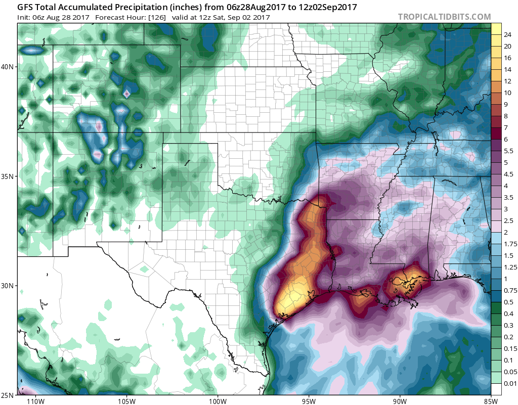
RAINFALL: Harvey is expected to produce additional rainfall
accumulations of 15 to 25 inches through Friday over the upper Texas
coast and into southwestern Louisiana. Isolated storm totals may
reach 50 inches over the upper Texas coast, including the Houston/
Galveston metropolitan area. These rains are currently producing
catastrophic and life-threatening flooding, and flash flood
emergencies are in effect for portions of southeastern Texas.
DO NOT ATTEMPT TO TRAVEL IN THE AFFECTED AREA IF YOU ARE IN A SAFE
PLACE. DO NOT DRIVE INTO FLOODED ROADWAYS. Please see warnings and
products issued by your local National Weather Service office for
additional information on this life-threatening situation.
Elsewhere, Harvey is expected to produce total rain accumulations of
5 to 15 inches farther south into the middle Texas coast, farther
west toward the Texas Hill Country, and farther east across south-
central Louisiana.

MANY THANKS TO TROPICAL TIDBITS FOR THE WONDERFUL USE OF THE MAPS
Weather App

Don’t be without Meteorologist Joe Cioffi’s weather app. It is really a meteorologist app because you get my forecasts and my analysis and not some automated computer generated forecast based on the GFS model. This is why your app forecast changes every 6 hours. It is model driven with no human input at all. It gives you an icon, a temperature and no insight whatsoever.
It is a complete weather app to suit your forecast needs. All the weather information you need is right on your phone. Android or I-phone, use it to keep track of all the latest weather information and forecasts. This weather app is also free of advertising so you don’t have to worry about security issues with your device. An accurate forecast and no worries that your device is being compromised.
Use it in conjunction with my website and my facebook and twitter and you have complete weather coverage of all the latest weather and the long range outlook. The website has been redone and upgraded. Its easy to use and everything is archived so you can see how well Joe does or doesn’t do when it comes to forecasts and outlooks.
Just click on the google play button or the apple store button on the sidebar for my app which is on My Weather Concierge. Download the app for free. Subscribe to my forecasts on an ad free environment for just 99 cents a month.
Get my forecasts in the palm of your hand for less than the cost of a cup of Joe!