Happy New Year Some Sunshine Seasonal Temps. Rain Friday Weekend
We start January and 2020 sitting in some leftover clouds this morning but the clouds are rather on the thin side and the sun should be able to cut through those clouds in short order and get us at least to partly sunny conditions. Slightly colder air is here today as we bottomed in the 30s this morning and we should get back to the upper 30s and lower 40s this afternoon. There aren’t any serious weather issues to speak of today other than clouds from time to time and a bit of a gusy breeze into this afternoon.
SATELLITE

REGIONAL RADAR

We are seeing some patchy areas of snow showers this morning on the radar off the east shores of Lake Ontario as well as coming into SW NY off of Lake Erie Otherwise the radars both regional and local are quiet for the most part and should remain that way into Thursday.
LOCAL RADAR NEW YORK CITY

LOCAL RADAR PHILADELPHIA


Skies should clear out tonight with morning lows in the 20s to near 30. Thursday starts with some sunshine but there will be some clouds arriving as the day wears on. Highs will be back into the 40s by days end. Then the next round of wet weather begins later Thursday night into Friday.
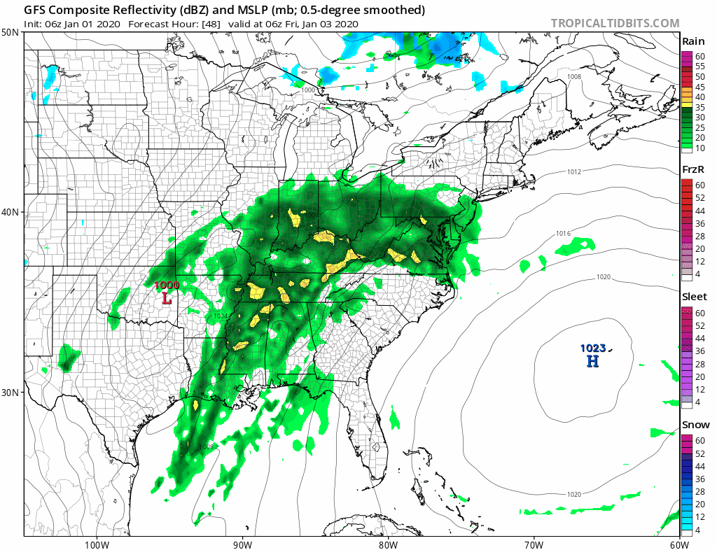
A warm front attempts to move up from the south Thursday night into Friday which will bring an area of rain through here arriving during the early morning hours of Friday and then done by midday. Then we have low pressure that will swing across the Ohio Valley for Friday night into Saturday with another round of rain possible. Some snow is likely in upstate NY and New England fro m this. Until the frontal boundary passes south again highs Friday will be in the 40s with 50s from South Jersey southward. Saturday’s highs will be in the 50s everywhere.

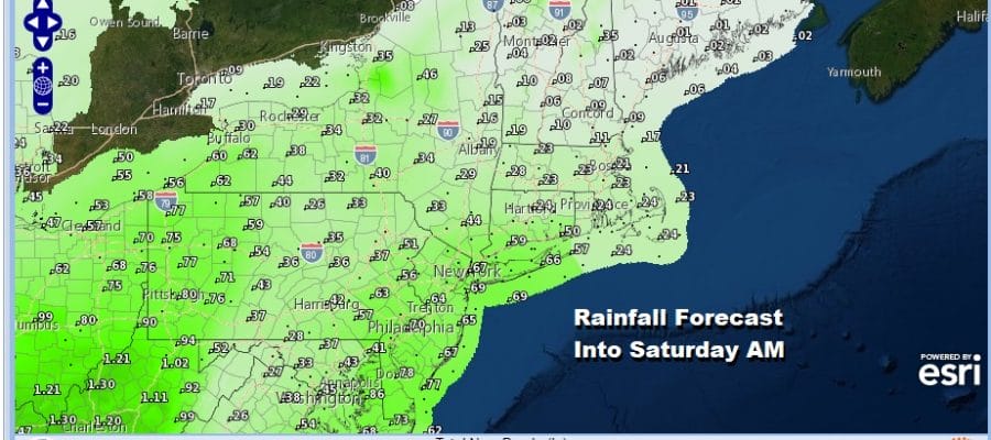
The wet weather pattern that has been persistent since mid October continues with rainfall amounts of 1/2 to 3/4 inch forecast into Saturday morning and then there could be additional rain on Saturday as a front goes by and a second low moves from west to east across Pennsylvania to Southern New England. Some of the models are further south and colder for Saturday night and Sunday which might lead to the rain ending as a little bit of snow across Southern New England and perhaps the Hudson Valley. It looks like a long shot at this stage. A step down to colder weather arrives Sunday and early next week as another cold front passes through on Monday.
BE SURE TO DOWNLOAD THE FREE METEOROLOGIST JOE CIOFFI WEATHER APP &
ANGRY BEN’S FREE WEATHER APP “THE ANGRY WEATHERMAN!
MANY THANKS TO TROPICAL TIDBITS FOR THE USE OF MAPS
Please note that with regards to any severe weather, tropical storms, or hurricanes, should a storm be threatening, please consult your local National Weather Service office or your local government officials about what action you should be taking to protect life and property.


