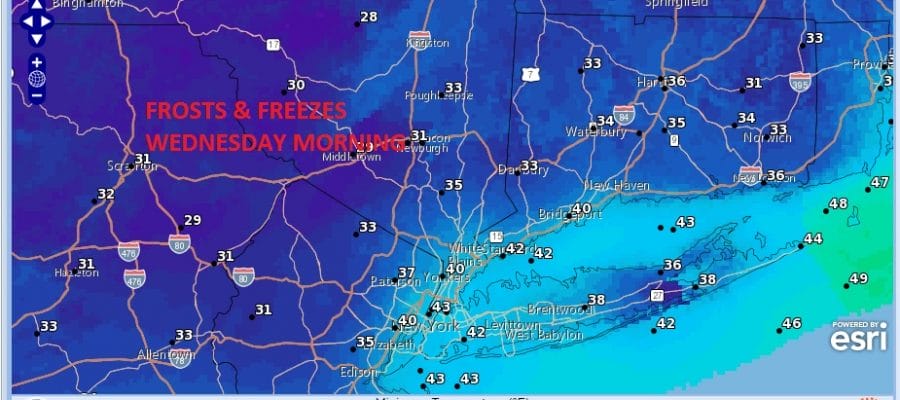
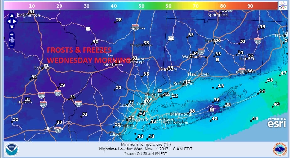
Frost Freeze Wednesday Morning Inland & Long Island
SHOP THE JOESTRADAMUS STORE
Frost Freeze Wednesday Morning Inland & Long Island
Our weather is still being controlled by a deep upper air cyclone up in Canada and a chilly west northwest flow. You can see on the satellite loop that while yesterday’s major storm has moved to the north into Canada another arm is swinging around with clouds and a chilly air mass behind it. This will set us up for a frost freeze Wednesday morning in areas just north and west of the warmer urban settings and in Central & Eastern Long Island.
WEDNESDAY MORNING FORECAST LOW TEMPREATURES FROST FREEZE LIKELY
SATELLITE LOOP

Meanwhile tonight will be partially clear though some clouds might come into the mix. Most lows will be in the upper 30s to middle 40s. With that next disturbance swinging around there are clouds and some showers with it. While the clouds will likely survive to some degree, much of the shower activity should be left to our west on Tuesday making for a mix of sun and clouds with highs in the 50s.
REGIONAL RADAR

The cool shot will begin to pull out on Wednesday so look for sunshine giving way to some arriving clouds. Highs will be in the 50s. Then as milder air arrives we could see a shower Wednesday night. Thursday we will see clouds and some sun with the chance for a shower and highs in the 60s. Friday looks like we could reach 70 or better with clouds and sun and the chance for a shower. No big storms on the horizon though an onshore flow and a weak system could bring some showers over the weekend.
 GET JOE A CIGAR IF YOU LIKE

FiOS1 News Weather Forecast For Long Island
FiOS1 News Weather Forecast For New Jersey
FiOS1 News Weather Forecast For Hudson Valley


