Frost Advisory NW New Jersey Hudson Valley Interior Connecticut
SHOP THE JOESTRADAMUS STORE
Frost Advisory NW New Jersey Hudson Valley
Interior Connecticut
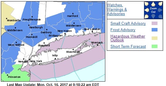
Cooler air is finally beginning to arrive and there is a Frost Advisory posted for much of Northern & Western New Jersey, parts of Eastern Pennsylvania in the counties between Allentown & Scranton, the Hudson Valley eastward across Connecticut north of Route 15. This morning we have the cold front dropping southward with showers still on the radar from Virginia to Delmarva, Southern New Jersey and offshore. To the north dry air is pushing southward on gusty northwest winds and that will continue through this afternoon and evening with temperatures just into the 60s.
SATELLITE LOOP

REGIONAL RADAR

Much of the shower activity should decrease as the day wears on and radars should go silent later today and remain so all week.
LOCAL RADAR NEW YORK CITY

LOCAL RADAR PHILADELPHIA


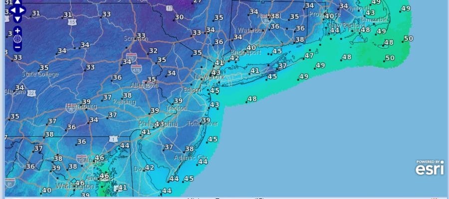
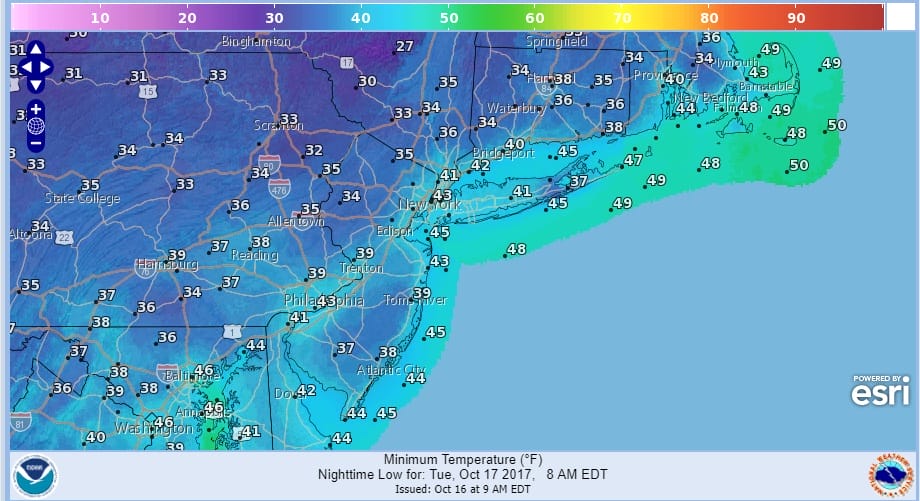
Look for a cold clear night tonight across the entire region. Tuesday morning lows will be in the mid 30s to lower 40s and some frost is possible in the frost advisory area.
FROST ADVISORY TUESDAY MORNING FORECAST LOWS
There is no change in the outlook for the week ahead. Tuesday will be sunny and cool with highs in the upper 50s to lower 60s. Wednesday looks mostly sunny with highs in the 60s. High pressure will remain stationary along the east coast all week which means temperatures will begin to warm again Thursday and Friday with sunshine and highs back into the 70s. No important rain is in sight probably through the weekend.
Post Hurricane Ophelia is battering Ireland this morning with gusts past hurricane force in many areas. JOESTRADAMUS has the latest on Ophelia and its impact to the British Isles.
 GET JOE A CIGAR IF YOU LIKE

FiOS1 News Weather Forecast For Long Island
FiOS1 News Weather Forecast For New Jersey
FiOS1 News Weather Forecast For Hudson Valley


