

Flood Watch Western NJ Eastern Pennsylvania
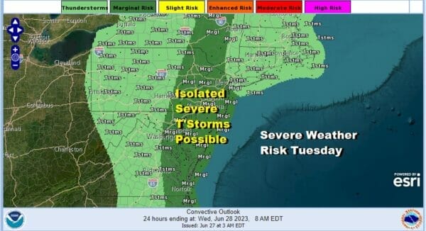
Chance For Showers Isolated Severe Thunderstorms Late Today & Wednesday

Flood Watches are posted for the Western and Northwestern Counties of New Jersey, mainly northwest of the NJ Turnpike, as well as much of Eastern Pennsylvania. Yesterday’s thunderstorms produced 6 inch plus rainfalls in parts of this zone so any additional rain from thunderstorms today will cause flooding rather quickly.
Today begins another day of warm humid air moving northward along the Eastern Seaboard. A cold front has crept closer today and sits across Central NY to Eastern Pennsylvania south to Eastern Virginia. This front is literally crawling eastward and you can see on the satellite loop that clouds are still moving from south to north which means the front is fighting the upper air southerly flow.
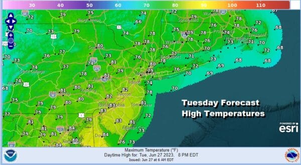
It will take another day and a half for the front to pass so that leaves us warm and humid today with breaks of sunshine and highs reaching the upper 70s and lower 80s. The moist southerly flow aloft and the cold front to the west will set off some showers and thunderstorms this afternoon and evening. There is the risk for isolated severe thundertorms popping up in the mix per the Storm Prediction Center. The main risk is low for gusty winds but the bigger issue will be any heavy rain produced in areas that got clobbered yesterday inland.
SATELLITE

WEATHER RADAR

Going forward for the rest of the week, it looks as if we have one more day to deal with the risk for showers and thunderstorms and that will be Wednesday. We need to finally get the cold front and upper trough to pass to the east and that should finally occur Wednesday evening.

After another warm humid night tonight with lows Wednesday morning in the mid 60s to around 70, we should see some sunshine along with clouds Wednesday and the chance for scattered downpours or a thunderstorm Wednesday afternoon and evening. Highs will be in the upper 70s and lower 80s.

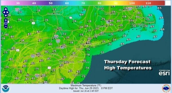
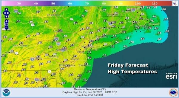
Thursday and Friday we may catch a break as humidity levels will ease somewhat. It will be borderline humid but given the humid conditions we see now, even a small drop should make things feel a little better. We will likely not see any showers or thunderstorms Thursday and Friday. Both days should be no worse than partly sunny. High temperatures Thursday and Friday will reach into the 80s except it will be a few degrees cooler along the shore.
The next round of upper troughs and cold fronts will be moving in for the weekend. We keep seeing these upper air storms and troughs dropping into the Eastern US. This is keeping us from getting into a summer time heatwave type pattern so temperatures look to be close to average for this time of year. However these systems will be rotating slowly through and that opens the door for showers and thunderstorms Saturday and Sunday.

This time of year it is hard to have whole days washed away by rains so the best approach to the weekend outlook is to say that there will be dry stretches but some areas will see showers and thunderstorms going by early in the day Saturday and again late in the day. Sunday we also see the chance for showers and thunderstorms. Highs both days will be in the upper 70s and lower 80s. The upper trough and cold front will linger into Monday but there is hope that we could see improvement for later Monday and Tuesday, the July 4th holiday. Right now we will lean optimisitc for both those days.
BE SURE TO DOWNLOAD THE FREE METEOROLOGIST JOE CIOFFI WEATHER APP &
ANGRY BEN’S FREE WEATHER APP “THE ANGRY WEATHERMAN!
MANY THANKS TO TROPICAL TIDBITS FOR THE USE OF MAPS
Please note that with regards to any severe weather, tropical storms, or hurricanes, should a storm be threatening, please consult your local National Weather Service office or your local government officials about what action you should be taking to protect life and property.
(Amazon is an affilate of Meteorologist Joe Cioffi & earns commissions on sales.)


