DOWNLOAD MY NEW FREE JOESTRADAMUS WEATHER APP FOR ANDROID

Flood Watch SE PA All of New Jersey, Lower Hudson Valley NYC

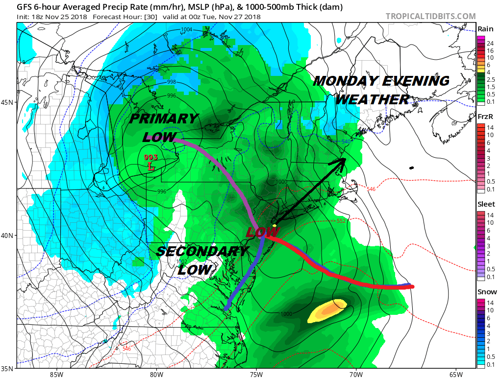
The Winter Storm impacting parts of the Midwest will have its impact on the Northeast as clouds on the satellite loop continue to increase this morning. Flood Watch is posted for areas from Extreme Southeastern Pennsylvania to all of New Jersey, New York City, and the lower Hudson Valley south of Route 84. We also have various Coastal Flood Advisories and Coastal Flood Warnings up due to the high tide off the full moon and an increasing southeast flow off the ocean.
EASTERN SATELLITE

REGIONAL RADAR

Radars are loading up to our south west. We are already see some showers moving through Southeast Pennsylvania on both the regional and local radars. The steadier rain is bit further west and that will get here around lunchtime. Rain will be falling through the afternoon and into the evening with some locally heavy downpours.
LOCAL RADAR NEW YORK CITY

LOCAL RADAR PHILADELPHIA


Low pressure which represents the Midwest storm will head toward Lake Erie and fall apart as a secondary develops over New Jersey. Once that low goes to our north we will see the rain end and weather conditions improve. That should begin to happen during this evening from south to north. Temperatures today will be in the 50s though some areas north of NYC might not get much out of the 40s.
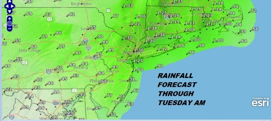
Rainfall amounts will be on the order of 1 to 2 inches which could be enough to set off flooding since we had 2 to 3 inches of rain on Saturday so the flood threshold is low. Weather conditions improve Tuesday through Thursday with some sunshine each day and highs in the 40s. A weak system approaches on Friday with cloudy skies and the chance for some rain. It might be cold enough for some snow inland. Right now the system looks weak. We will look at this a bit closer later today.
SUBSCRIBE TO PATREON FOR A WEATHER EXPERIENCE FREE OF ADS, EXCLUSIVE VIDEOS FOR MEMBERS ONLY AND MUCH MORE…STARTS AT $2 A MONTH..MESSAGE ME AT ANY TIME

MANY THANKS TO TROPICAL TIDBITS FOR THE USE OF MAPS
Please note that with regards to any tropical storms or hurricanes, should a storm be threatening, please consult your local National Weather Service office or your local government officials about what action you should be taking to protect life and property.

