Rain Continues Into Tonight With Lots of Clouds
More Rain Later Tomorrow into Monday
Flood Watch Western NJ Counties & Much of Pennsylvania
New Moon Coastal Flooding Possble Next Several Days
Latest on Florence
We certainly have much to cover this evening as an east west band of rain developed today across Pennsylvania into the Lower Hudson Valley to about Long Island and extending southward into Northern New Jersey. This area should try and sink southward this evening. There is some dry air to the north east but it seems a long way off on the satellite loop this evening and it seems a stretch to think it could ever make it this far south. Otherwise the northeast wind continues with temperatures that have settled in the cool 60s. This is all setting us up for the remnants of Tropical Storm Gordon which will be headed here to some degree with rain for later tomorrow into Monday,
EASTERN SATELLITE

REGIONAL RADAR

Much of the rain is steady but on the light side this evening as it move to the east on the regional radar. Notice the rain was more in South Jersey early today. There is less there now and more as you go north.
LOCAL RADAR NEW YORK CITY

LOCAL RADAR PHILADELPHIA


Gloomy conditions continue on Sunday with lots of clouds an rain moving back northward across Pennsylvania and reaching back into Northern New Jersey, NYC, Long Island & Southern New England come late in the day Sunday or Sunday evening. Most highs will just be in the low to mid 60s. Then it will rain overnight into Monday as a warm front tries to come up from the south. Highs will be back into the 70s.

The NAM model and others are rather bullish on rainfall amounts tonight through Monday with 1 to 2 inches of rain along the coast and 2 to 3 inches of rain inland. Higher amounts are possible in parts of Central Pennsylvania closer to where the remnants of Gordon are likely to pass.
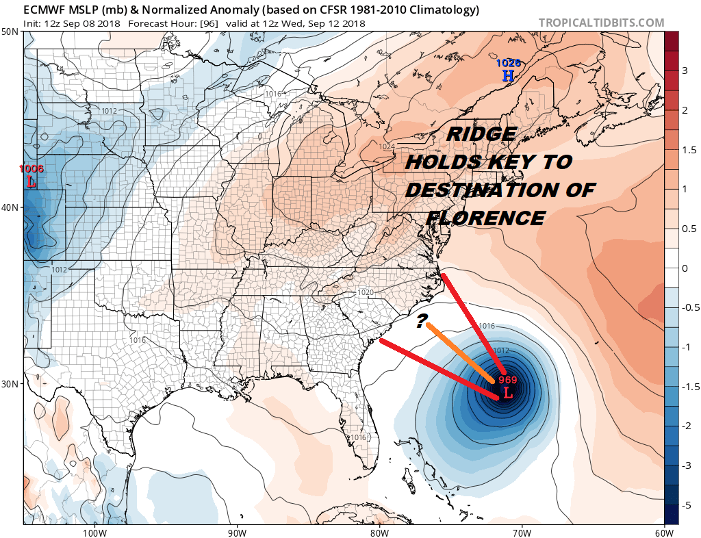
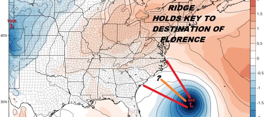
Weather conditions improve on Tuesday as it turns warm and humid for the rest of the week. This increase of humidity and warm air is basically preparing the East Coast for the arrival of Florence, likely as a major hurricane. Today’s weather models were shifting a little further northeast along the Carolina Coast. The map above is the European model’s view of things Wednesday morning with the hurricane approaching the Carolinas. The European went northeast with a landfall now in SW North Carolina vs a couple of runs near Charleston. The GFS actaully shows no landfall keeping it just east of the outer banks but I think that could be a function of the model showing a very low unrealistic pressure on the hurricane.
EASTERN SATELLITE

Satellite pictures and a NOAA plane found that Florence is getting better organized with top winds now back to 70 mph. It is likely to become a hurricane overnight and a major hurricane on Monday. Florence is moving west and it appears it will miss the chance to turn before it gets to 60 degrees west. As far as our area is concerned I am feeling somewhat confident that the impacts here should be minimal as long as the track remains toward the Carolinas. There isn’t much to steer it up here from what I can see unless the upper high to the north breaks down somewhat. That shows no signs of happening.
 GET JOE A CIGAR IF YOU LIKE

FiOS1 News Weather Forecast For Long Island
FiOS1 News Weather Forecast For New Jersey
FiOS1 News Weather Forecast For Hudson Valley
NATIONAL WEATHER SERVICE SNOW FORECASTS
LATEST JOESTRADAMUS ON THE LONG RANGE


