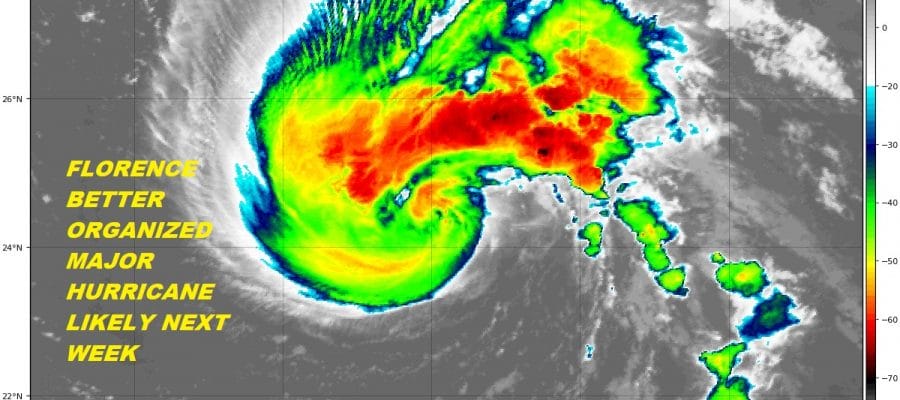
FLORENCE GETTING BETTER ORGANIZED
FORECAST TO BECOME A MAJOR HURRICANE NEXT WEEK
THREAT TO EAST COAST GROWS
The wide Atlantic satellite loop is rather busy looking this morning with 2 tropical storms and 1 tropical depression. Tropical Storm Florence lies near the upper center of the loop while Tropical Storm Helene in in the lower right corner. Tropical Depression 9 is to the left of Helene and that is forecast to become a tropical storm at some point over the weekend. Florence however is front and center now as the storm has survived the wind shear and is slowly organizing again.
WIDE ATLANTIC TROPICAL SATELLITE

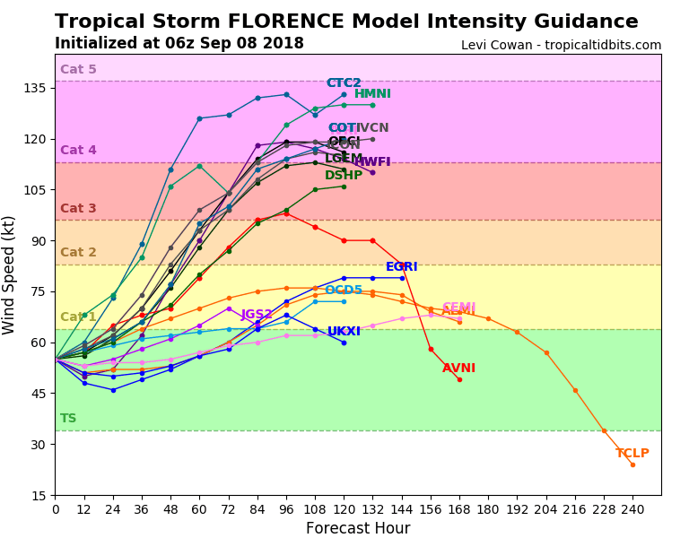
All indications are that Florence will become a hurricane on Sunday (or possible sooner) and then become a major hurricane by Tuesday (or sooner) as conditions actually do suggest rapid strengthening is possible once Florence reaches 60 degrees west. That will occur sometime Monday morning. Ocean water temperatures in the area between Bermuda and the Antilles are running almost 4 degrees F above average. Light wind conditions aloft and an excellent outflow pattern all point to at least a category 4 storm developing. The weaker Florence resulted a track that was actually south of west causing Florence not to gain latitude (move further north). This increased the chances of Florence reaching the East Coast. Florence will completely miss any opportunity to recurve, The threat for major hurricane impacting the East Coast has increased substantially.
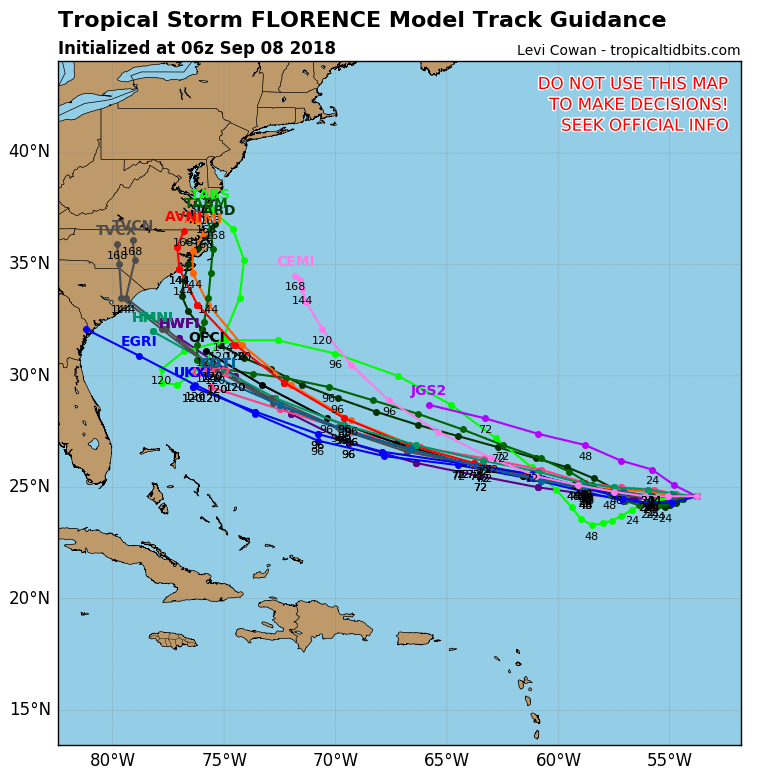
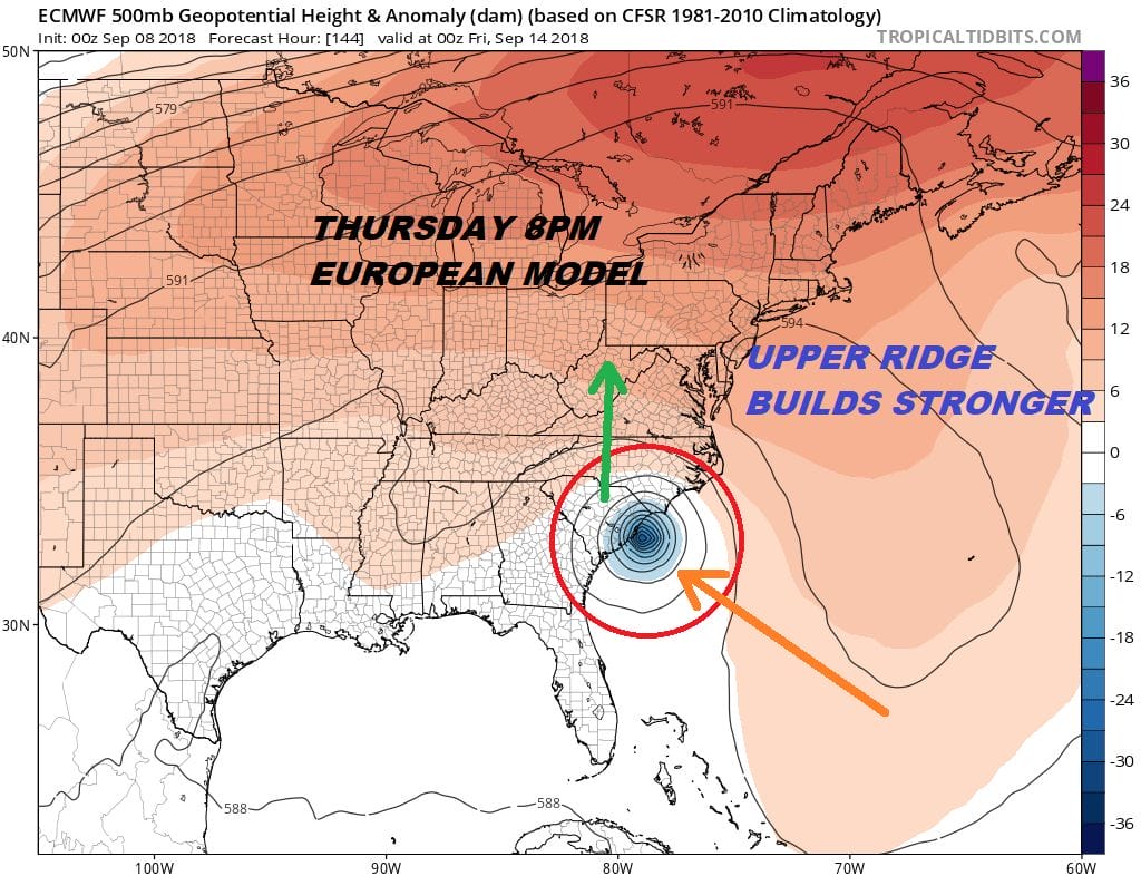
Of course the big question is where and when. The where appears to be sometime on Thursday. The where is another matter. The hurricane tracking models above show them clustered together for the most and then they diverge somewhat as they near the coast. The spread yesterday began to narrow between the Georgia Coast and the North Carolina Coast. The spread hasn’t tightened much overnight. so the area remains pretty wide. This is all going to depend on the strength of the upper high that develops off the East Coast as this is what is driving it northwestward and preventing it from going out to the north or northeast.
The European model splits the difference between the Canadian which takes it to the Georgia coast and the GFS which takes to coastal North Carolina. I think that is a fair assessment of the area of greatest risk. A strong ridge would take it further southwest but we need to be cautious here. If Florence strengthens to a category 4 hurricane it could favor a more northerly course which would then lean more toward the GFS model which actually sees this as a category 4 hurricane while the European pressure on Florence suggests a category 2. The intensity models are very impressive with a number of them going to category 4 and some of them get there quickly.
Then there is the upper high in all of this which is the major player all the way around with the European and the Canadian far stronger with it. Right now I’m feeling cautiously comfortable with a track toward the Southeast coast and we will wait to narrow things down until we get a better idea of what we are dealing with exactly. The European scenario above would be especially problematic for the inland areas in the Central Appalachians and the Blue Ridge Mountains where flooding torrential rains could occur. We will put this on the back burner for the time being.
THANKS TO TROPICAL TIDBITS FOR THE USE OF MAPS
Please consult your local National Weather Service office at weather.gov for the latest information on any tropical or storms or hurricanes that could be a threat to your area. Consult your local government officials regarding action you may need to take to secure life and property
FiOS1 News Weather Forecast For Long Island
FiOS1 News Weather Forecast For New Jersey
FiOS1 News Weather Forecast For Hudson Valley