
Flash Flood Watch Central South Jersey SE PA, Severe Weather Risk Coastal NJ NYC & Long Island
Flash Flood Watch Central South Jersey SE PA,
Severe Weather Risk Coastal NJ NYC & Long Island
The unusual set up for let July continues to play out as low pressure develops this morning along the Outer Banks of North Carolina. This non tropical system will behave in a tropical like way as it moves northward today and tonight. We are starting the day dry with sunshine but clouds will be increasing and rain will be spreading from south to north arriving in South Jersey in the next few hours and reaching NYC late this afternoon. The low is tracking northward and will likely take a hook to the northwest tonight. The low track just inland along the Pennsylvania New Jersey border will likely bring heavy rains along and west of the track on the order of 2 to 3 inches. To the east two bands of thunderstorms will lift northward and from these bands there is the risk of severe weather as indicated by the Storm Prediction Center.
EASTERN SATELLITE

REGIONAL RADAR

Regional radar shows the north south area of downpours moving steadily northward. Look for local radars below to become more active as the day wears on.
LOCAL RADAR NEW YORK CITY

LOCAL RADAR PHILADELPHIA


This is about a 6 to 8 hour period of rough weather overnight from Northeast Pennsylvania eastward to Northern New Jersey, New York City to Southern New England and Long Island. Along te coast of New Jersey and Long Island gale force wind gusts of 40 mph+ are likely as two bands of heavy thunderstorms swing through.
HRRR WIND FORECAST MIDNIGHT TONIGHT

The HRRR has a bit more of a wrapped of low this morning tracking northward toward Eastern Pennsylvania which puts the axis of the heavy rains along and west of the low track. All of this plays out fast and the low should be north of us by daybreak. Weather conditions across Southern New Jersey and Southeastern Pennsylvania should start to improve overnight with areas from NYC northward starting to see improvement around daybreak or so.
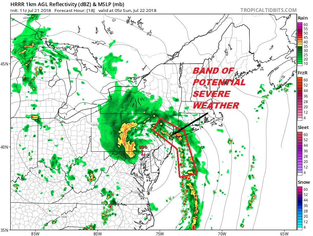
The important thing to watch is the band indicated in red on the HRRR model as it moves through the NYC, Northern New Jersey Long Island area from 10pm-2am. It is from this band that we could see some severe thunderstorms and brief strong wind gusts as the band moves through.
Sunday should see some improvement but the moist upper flow remains southerly. We should see sunshine break through the clouds with very humid conditions and the risk for some more downpours though they should be scattered in nature. Temperatures will reach into the 80s. Next week will be very humid with temperatures in the 80s and the risk for downpours or thunderstorms every day.
Please note that with regards to any tropical storms or hurricanes, should a storm be threatening, please consult your local National Weather Service office or your local government officials about what action you should be taking to protect life and property.
 GET JOE A CIGAR IF YOU LIKE

LATEST JOESTRADAMUS ON THE LONG RANGE


