Flash Flood Warnings Severe Thunderstorm Warnings
Flash Flood Warnings Severe Thunderstorm Warnings
We continue to see thunderstorms producing severe weather and heavy rains over parts of the area. The satellite loop also shows a blow up of thunderstorms across Northern Pennsylvania and Southern New York that is now pushing eastward. This has the potential to bring substantial rains overnight to a large portion of the area from Northern New Jersey and the Hudson Valley eastward to Connecticut and Long Island.


THE NATIONAL WEATHER SERVICE IN UPTON NY HAS ISSUED A

* FLASH FLOOD WARNING FOR...
  ORANGE COUNTY IN SOUTHEASTERN NEW YORK...

* UNTIL 1145 PM EDT

* AT 849 PM EDT...DOPPLER RADAR INDICATED THUNDERSTORMS PRODUCING
  HEAVY RAIN ACROSS THE WARNED AREA. UP TO TWO INCHES OF RAIN HAVE
  ALREADY FALLEN. FLASH FLOODING IS EXPECTED TO BEGIN SHORTLY.

* SOME LOCATIONS THAT WILL EXPERIENCE FLOODING INCLUDE...
  MIDDLETOWN...PORT JERVIS...MONROE...WALDEN...WARWICK...GOSHEN...CHESTER...
  MONTGOMERY...FLORIDA...HARRIMAN...UNIONVILLE...OAKLAND...KIRYAS JOEL...
  WASHINGTONVILLE...MAYBROOK...PINE BUSH...HIGHLAND MILLS...SCOTCHTOWN
  AND CENTRAL VALLEY.


THE NATIONAL WEATHER SERVICE IN MOUNT HOLLY NJ  HAS EXTENDED THE

* FLASH FLOOD WARNING FOR...
  SOUTHEASTERN HUNTERDON COUNTY IN NORTHWESTERN NEW JERSEY...
  SOUTHWESTERN SOMERSET COUNTY IN NORTHERN NEW JERSEY...

* UNTIL 1230 AM EDT

* AT 823 PM EDT...THE NESHANIC RIVER AT REAVILLE WAS 8.2 FEET AND
  RISING. FLOOD STAGE AT REAVILLE IS 6.5 FEET. WHILE HEAVY RAIN HAS
  MOVED OUT OF THE WARNED AREA...SOME STREAMS SUCH AS THE NESHANIC
  RIVER REMAIN OUT OF THEIR BANKS. THE FLASH FLOOD WARNING HAS
  THEREFORE BEEN EXTENDED UNTIL AFTER MIDNIGHT.
 SEVERE THUNDERSTORM WARNING FOR...
  SOUTHERN DUTCHESS COUNTY IN EAST CENTRAL NEW YORK...

* UNTIL 1015 PM EDT

* AT 922 PM EDT...A SEVERE THUNDERSTORM WAS LOCATED OVER BEACON...
  MOVING EAST AT 20 MPH.

  HAZARD...60 MPH WIND GUSTS AND QUARTER SIZE HAIL.

  SOURCE...RADAR INDICATED.

  IMPACT...HAIL DAMAGE TO VEHICLES IS EXPECTED. EXPECT WIND DAMAGE
           TO ROOFS...SIDING...AND TREES.

* LOCATIONS IMPACTED INCLUDE...
  BEACON...SHERMAN...PAWLING...WAPPINGERS FALLS...FISHKILL...
  WINGDALE...HOPEWELL JUNCTION...MYERS CORNER...DOVER PLAINS...
  EAST FISHKILL...BEEKMAN...WICCOPEE...ARTHURSBURG...HILLSIDE LAKE...
  CLOVE...DOVER FURNACE...NEW HAMBURG...WEST PAWLING...
  HURD CORNERS AND ONIONTOWN.
Flash Flood Severe Thunderstorms Overnight
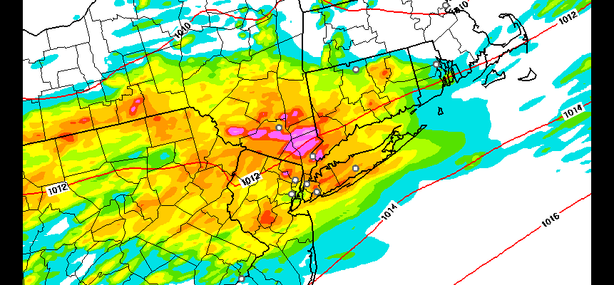
Latest HRRR Model Rainfall Forecast
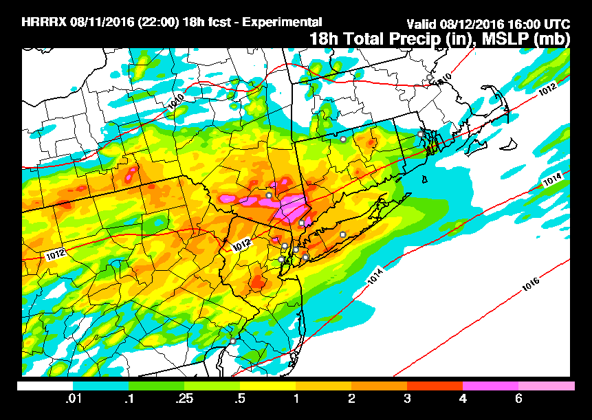
The very latest HRRR model shows parts of the Hudson Valley getting 6 inches or more of rain between now and 12 noon Friday. All of this should be done by daybreak. Heavy pockets of rain shown over parts of Northern New Jersey & Long Island. This could be drought denting in a big way.
FiOS1 News Weather Forecast For Long Island
FiOS1 News Weather Forecast For New Jersey
FiOS1 News Weather Forecast For Hudson Valley
NATIONAL WEATHER SERVICE SNOW FORECASTS
LATEST JOESTRADAMUS ON THE LONG RANGE
Weather App

Don’t be without Meteorologist Joe Cioffi’s weather app. It is really a meteorologist app because you get my forecasts and my analysis and not some automated computer generated forecast based on the GFS model. This is why your app forecast changes every 6 hours. It is model driven with no human input at all. It gives you an icon, a temperature and no insight whatsoever.
It is a complete weather app to suit your forecast needs. All the weather information you need is right on your phone. Android or I-phone, use it to keep track of all the latest weather information and forecasts. This weather app is also free of advertising so you don’t have to worry about security issues with your device. An accurate forecast and no worries that your device is being compromised.
Use it in conjunction with my website and my facebook and twitter and you have complete weather coverage of all the latest weather and the long range outlook. The website has been redone and upgraded. Its easy to use and everything is archived so you can see how well Joe does or doesn’t do when it comes to forecasts and outlooks.
Just click on the google play button or the apple store button on the sidebar for my app which is on My Weather Concierge. Download the app for free. Subscribe to my forecasts on an ad free environment for just 99 cents a month.
Get my forecasts in the palm of your hand for less than the cost of a cup of Joe!

MENTION JOE CIOFFI AND GET A 5% DISCOUNT


