DOWNLOAD MY NEW FREE JOESTRADAMUS WEATHER APP FOR ALL DEVICES
THE APP IS ABSOLUTELY FREE TO ALL BUT CONSIDERING SUBSCRIBING TO PATREON FOR A WEATHER EXPERIENCE FREE OF ADS, EXCLUSIVE VIDEOS FOR MEMBERS ONLY AND MUCH MORE…STARTS AT $2 A MONTH..MESSAGE ME AT ANY TIME
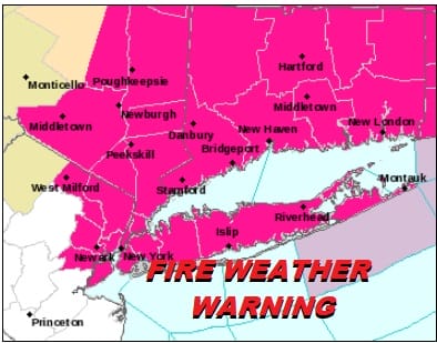
Fire Weather Warning Northeast New Jersey Hudson Valley Long Island Connecticut

Bone dry conditions yesterday where relative humidity levels were down as low as 10 percent continue today and the area shifts a little further to the east from Northeast New Jersey to Southern New England and Long Island. This will be the last day of the super desert dry conditions as low pressure to the west and a warm front sets up to our south tonight and Friday. We should see sunshine for a good part of the day with some high clouds arriving later this afternoon and evening. Temperatures today will be a little cooler than yesterday with highs in the 50s to near 60.
SATELLITE

REGIONAL RADAR

Clouds will thicken up tonight as the onshore flow begins and strengthens and that brings a miserable finish to the week for Friday. Cloudy skies, an ocean wind will keep temperatures mostly in the 40s. There will be some rain coming in during the afternoon and into tomorrow. This doesn’t look to be a big rain producer but it could be on the order of a half inch to an inch. If it comes in fast enough in the Hudson Valley well north of Route 84 there could be some sleet or wet snow in the mix at the start for a last gasp breath from winter.
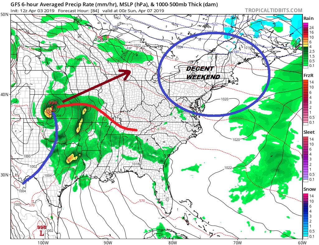
We are still thinking that the weekend will be decent. There will be leftover clouds Saturday morning to get through but we should see some sunshine by afternoon in most places. There is no real cold air behind this system for Friday so highs should reach the 60s everywhere Saturday afternoon. Sunday looks good with sunshine giving way to some arriving clouds. Highs will be in the upper 50s and lower 60s as we once again begin to get into an onshore flow.

Then the next round of rain comes in Sunday night into Monday and this system will be another slow mover with a battle of the warm front trying to move northward. This is going to be a busy pattern ahead with weather systems coming through every couple of days so be sure to enjoy the nice weather while you have it.
MANY THANKS TO TROPICAL TIDBITS FOR THE USE OF MAPS
Please note that with regards to any tropical storms or hurricanes, should a storm be threatening, please consult your local National Weather Service office or your local government officials about what action you should be taking to protect life and property.


