Finally Let The Warm Up Begin Tuesday And Last Through Friday

Weather in 5/Joe & Joe Weather Show Latest Podcast
Finally Let The Warm Up Begin Tuesday And Last Through Friday
We are waiting for the warm front to move through and you can see it on the satellite picture as that area of high clouds that extends from Canada across Central NY and Central Pennsylvania. That marks the leading edge of the warm air. The front is weak so other than the clouds there are no issues regarding showers. We are seeing ample sunshine this afternoon filtered by some of those clouds. Temperatures are in the 40s. Once the front goes by the cold air will be to the east and temperatures will probably hold in the 30s to near 40 overnight with only the coldest spots well inland getting under freezing.
SATELLITE

Radars are nice and quiet for the most part other than one or two snow showers showing up well north in upstate New York. No precipitation is forecast into the first part of Friday.
F5 WEATHER RADARS


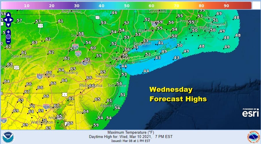
Tuesday we will see sunshine and the strengthening March sun will warm temperatures up nicely into the upper 50s and lower 60s. The challenge each day will be the temperatures and the wind direction. Wednesday we will see sunshine but we will also see a south wind which means areas from NYC eastward will have to deal with the wind coming in from off the ocean. Temperatures Wednesday will be in the 50s from there east. However inland and south it will be a different story as the south wind will warm temperatures up into the 60s. Some 70 degree readings are possible in parts of Southern Pennsylvania south into Maryland and Virginia.
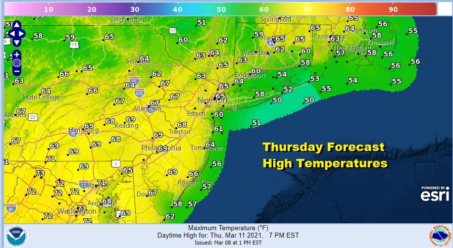
Thursday could be the day that we see some temperature upside as the wind becomes southwest to even west southwest and that will keep the sea breeze confined only to south facing shoreline areas. Highs could reach mid to upper 60s and it is possible that we could take out 70 degrees in many inland locations.
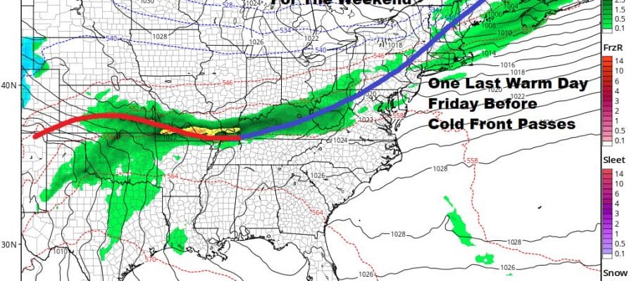
The next cold front looks to come through on Friday. There isn’t much support with this so I would look for nothing more than passing shower as it goes by. It will still be warm ahead of it with highs in the 60s to near 70 before the front passes and then chilly air follows for the weekend.
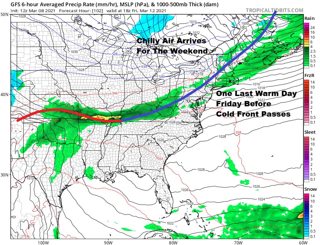
The weekend looks to be dry but temperatures will be colder. Saturday’s highs will be in the upper 40s and lower 50s everywhere and Sunday highs will be just in the low to mid 40s. Both days should feature some sunshine. Next week brings another cold front through at some point. The northern and southern jet should remain separate and cold air is likely not to hold in the east.
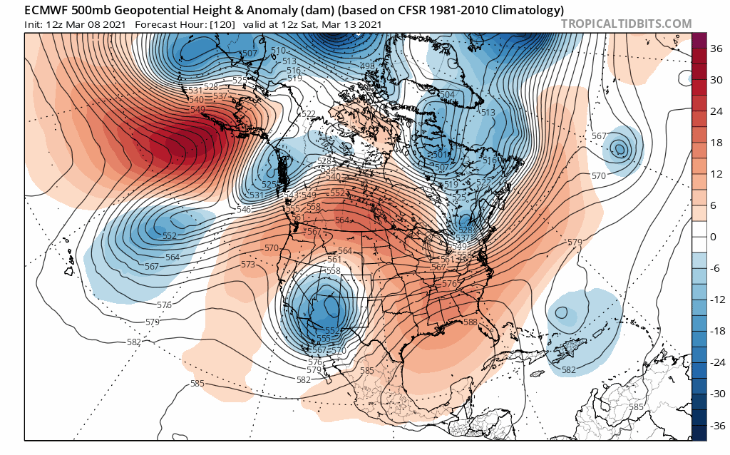
After an initial bout of confusion, it seems that strong troughing will drop into the Western US with ridging in the Eastern US. This may keep things mostly dry until the western trough swings east and that may take until later next week for that to happen. In the meantime cold air will be dropping down into the west creating snow from the Rockies westward. Things will be tranquil and a bit above average temperature wise in the East.
BE SURE TO DOWNLOAD THE FREE METEOROLOGIST JOE CIOFFI WEATHER APP &
ANGRY BEN’S FREE WEATHER APP “THE ANGRY WEATHERMAN!

MANY THANKS TO TROPICAL TIDBITS & F5 WEATHER FOR THE USE OF MAPS
Please note that with regards to any severe weather, tropical storms, or hurricanes, should a storm be threatening, please consult your local National Weather Service office or your local government officials about what action you should be taking to protect life and property.


