Cold Will Finally Abate Warmer Air Arrives Long Range Questions Appear

Weather in 5/Joe & Joe Weather Show Latest Podcast
Cold Will Finally Abate Warmer Air Arrives Long Range Questions Appear
When it is cold this time of year it had best be sunny and at least we had that today. Sunshine was able to take some of the sting out of the air even though temperatures topped out mostly in the 30s to near 40 or so. Skies are clear going into this evening and overnight we will see partly to mostly clear skies. Temperatures will head down to the teens inland and low 20s in warmer urban areas. Winds at least will drop off to under 5 mph in most places.
SATELLITE

As high pressure lies overhead and redevelops to the south the stable atmosphere means quiet radars everywhere up and down the East Coast and this will be the case for the most part this week.
F5 WEATHER RADARS


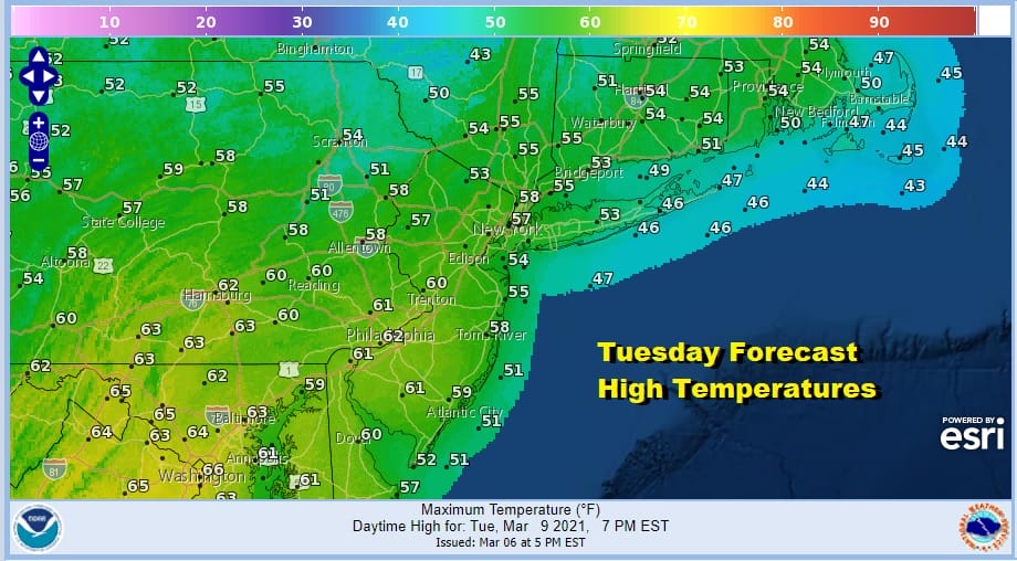
Monday will be the last day where temperatures are held back. Highs should be in the 40s everywhere and we should be no worse than partly sunny. A warm front moves across Southern Canada and upstate NY Monday night. Temperatures Monday night will likely go nowhere and hold mostly in the upper 20s to mid 30s. This should set us up with a good launching pad for Tuesday. Look for sunshine and highs in the 50s to near 60.
The position of the high is critical this time of year. A wind from the south and a wind from the southwest can make a huge difference. Wednesday could be a day where the south wind along the coast keeps temperatures lower especially along south facing shore lines. Inland areas should be able to reach the 60s.
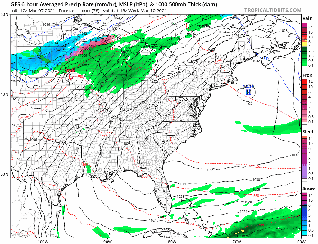
Thursday and Friday the winds will be west or west southwest which could take temperatures both days to the 60s to near 70 degrees. We do have a cold front that approaches Friday evening and there might be a passing shower with that front though it is quite possible that it comes through dry.
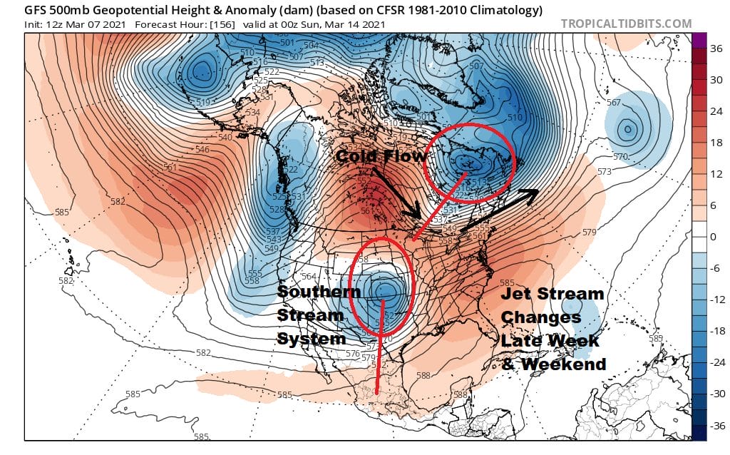
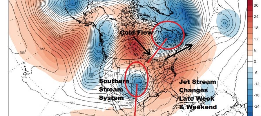
The weekend brings some changes to the upper air pattern. This is a time of year where often times we see a split flow with two separate jets. The northern stream from Canada is still active and that tries to bring down cold air into the US and in this case into the Eastern US. The southern stream is shooting energy across the US. This week that pathway is shut down but it does open up late this week with a southern stream system moving east. The flow from Canada will be nearby and the question will be whether that northern jet pulls out completely next weekend or does it hold in as the southern stream system approaches Sunday and Monday. This is how snow can happen this time of year. Weather models have been hinting back and forth on this idea and it is likely that the upper air is not done adjusting. For snow this time of year it has to be perfect. It is also a time of year where it can be 30s one day and 60s the next and then followed by 30s again. Other hints in the long range suggest the second half of March will be more active than the first half.
BE SURE TO DOWNLOAD THE FREE METEOROLOGIST JOE CIOFFI WEATHER APP &
ANGRY BEN’S FREE WEATHER APP “THE ANGRY WEATHERMAN!

MANY THANKS TO TROPICAL TIDBITS & F5 WEATHER FOR THE USE OF MAPS
Please note that with regards to any severe weather, tropical storms, or hurricanes, should a storm be threatening, please consult your local National Weather Service office or your local government officials about what action you should be taking to protect life and property.


