Fall Weather Arrives Tonight
Fall Weather Arrives Tonight 40s
Saturday & Sunday Night
Rain Tuesday
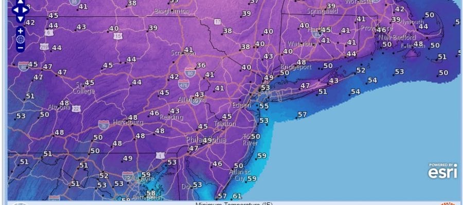
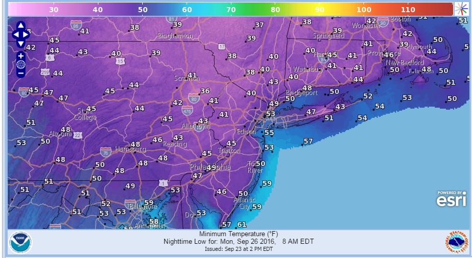
It will be a beautiful weekend of fall weather with sunshine both Saturday and Sunday. Temperatures will be below normal for a change for a few days. Nights will be nice and cool Saturday night and Sunday night with many areas bottoming in the 40s to around 50.
The cold front marking the leading edge of the cool air is dropping across upstate NY and should pass through this evening with minimal issues other than clouds and maybe an isolated brief shower. After it goes by skies should clear out from north to south after midnight.


Saturday looks great with lots of sunshine and a freshening north northeast wind. Typically cool air masses come in from the west or northwest. This one is coming down from the north which can sometimes make the bottom of the atmosphere cooler with a wind down from New England and Eastern Canada.

Monday morning will be the coolest of the next several mornings. 30s will make their first appearance of the season in the Hudson Valley & parts of Northwest New Jersey & Northeastern Pennsylvania. 40s will be everywhere except for the warmer urban areas and right along the immediate coast.
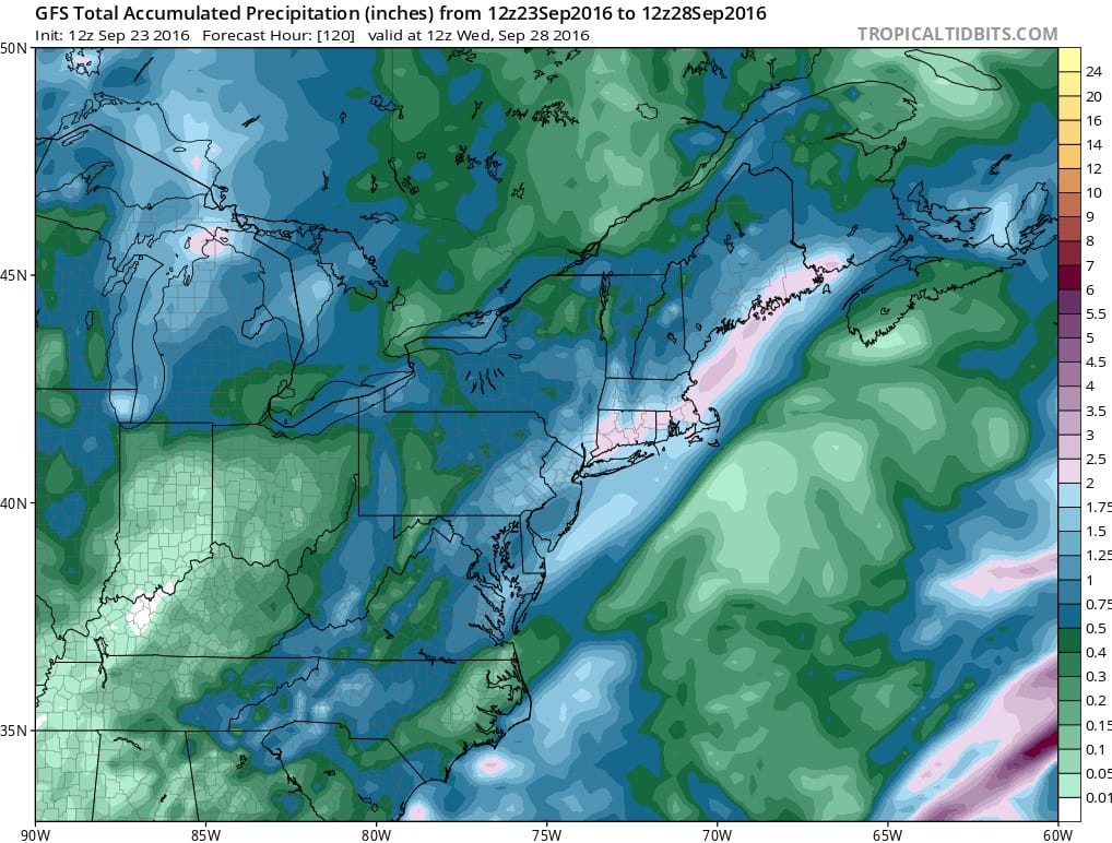
Monday looks good with sunshine though some clouds will arrive later in the day and at night. Monday night won’t be as cool as a front approaches on Tuesday. That front will take its time moving through and it does have some moisture to play with. Rain is likely Tuesday into Tuesday night. Models are bullish on rainfall amounts of 1 to 2 inches with higher amounts across Connecticut & Southern New England.
WINTER WEATHER OUTLOOK VIDEOS
In case you missed them I’ve been previewing the upcoming winter in a series of posts and videos. Here are the first 2. More will be coming along. Links to the latest posts are below.
NEW JERSEY
LONG ISLAND AND NEARBY
WINTER 2016-2017 PART 3 NEW JERSEY
WINTER 2016-2017 PART 1 OCEAN WATER TEMPERATURES
WINTER 2016-2017 PART 2 ARCTIC SEA ICE AND SIBERIAN SNOW COVER
FiOS1 News Weather Forecast For Long Island
FiOS1 News Weather Forecast For New Jersey
FiOS1 News Weather Forecast For Hudson Valley
NATIONAL WEATHER SERVICE SNOW FORECASTS
LATEST JOESTRADAMUS ON THE LONG RANGE

Weather App

Don’t be without Meteorologist Joe Cioffi’s weather app. It is really a meteorologist app because you get my forecasts and my analysis and not some automated computer generated forecast based on the GFS model. This is why your app forecast changes every 6 hours. It is model driven with no human input at all. It gives you an icon, a temperature and no insight whatsoever.
It is a complete weather app to suit your forecast needs. All the weather information you need is right on your phone. Android or I-phone, use it to keep track of all the latest weather information and forecasts. This weather app is also free of advertising so you don’t have to worry about security issues with your device. An accurate forecast and no worries that your device is being compromised.
Use it in conjunction with my website and my facebook and twitter and you have complete weather coverage of all the latest weather and the long range outlook. The website has been redone and upgraded. Its easy to use and everything is archived so you can see how well Joe does or doesn’t do when it comes to forecasts and outlooks.
Just click on the google play button or the apple store button on the sidebar for my app which is on My Weather Concierge. Download the app for free. Subscribe to my forecasts on an ad free environment for just 99 cents a month.
Get my forecasts in the palm of your hand for less than the cost of a cup of Joe!

MENTION JOE CIOFFI AND GET A 5% DISCOUNT


