European Model: Cold & Dynamic
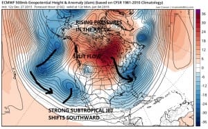
Today’s European model along with the last several runs was rather cold and very dynamic looking as we head into January. While it does not show anything very specific in terms of say a storm along the east coast or bitter cold Arctic air getting involved, it does show a rather dynamic pattern developing as we look down the road. There are of course no guarantees that it will be right but it is something that should raise eyebrows.

The European model continues showing the pattern evolving in this slow grinding process. A strong subtropical jet in the Pacific shifts southward toward Southern California which is typical in El Nino years. Meanwhile the pressures in the Arctic region continue to rise as warm air floods the region at mid levels. A colder flow is established from Canada into the East. All of this makes sense given the current model trends.

By Day 10 we continue to see the trends move along. The question will be at what point do we start getting weather systems to travel along the southern stream while the northern jet sets up around the strong Pacific ridge. A split flow is firmly established. Down the road the question will be whether all these things eventually line up for an east coast event. Also we have rising pressures in the Arctic continuing especially over Greenland as we begin to see the appearance of a blocking high. The European has been the most bullish on this idea over the last few days and continues on this road today.

The ensembles all seem to be on board with this idea which is another sign that the more wintry pattern will begin to take control as we head into January. Again there is nothing specific to point to at this time however the rather dynamic look that is being presented is something that will need to be considered at some point.
Here is the short range forecast video. Winter Weather Advisories are up for some areas. Check your local forecasts and the snow forecast pages with the links below.
NATIONAL WEATHER SERVICE SNOW FORECASTS
LATEST JOESTRADAMUS ON THE LONG RANGE
Weather App
Winter is coming. Don’t be without Meteorologist Joe Cioffi’s weather app. It is a complete weather app to suit your forecast needs. All the weather information you need is right on your phone. Android or I-phone, use it to keep track of all the latest weather information and forecasts. This weather app is also free of advertising so you don’t have to worry about security issues with your device. An accurate forecast and no worries that your device is being compromised.
Use it in conjunction with my website and my facebook and twitterand you have complete weather coverage of all the latest weather and the long range outlook. The website has been redone and upgraded. Its easy to use and everything is archived so you can see how well Joe does or doesn’t do when it comes to forecasts and outlooks.
Just click on the google play button or the apple store button on the sidebar for my app which is onMy Weather Concierge. Download the app for free. Subscribe to my forecasts on an ad free environment for just 99 cents a month.
Get my forecasts in the palm of your hand for less than the cost of a cup of Joe!


