European Weather Forecast Model Update
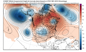
Right off the bat thanks to TROPICAL TIDBITS for the great maps and allow use of them. The overnight European weather forecast model illustrates the problems the models are having with the overall pattern and the persistent ridge that wants to continue to rebuild in the eastern United States. Early model runs showing a more important northern jet stream were wrong as that jet is forecast to be weaker and to pull out before anything comes our way from the Southwest. This has been an ongoing issue for weeks and until we see that ridge get out of the way and a complete reshifting of the overall pattern, even the split flow is not going to useful without some sort of cold air connection from Canada.
This on going issue can’t be resolved until things correct in Canada and the arctic. Meanwhile out at day 10 the same problem appears again.
Take a look at the European and GFS and look at the difference in Eastern Canada. The European wants to maintain more of a split with a colder look (relatively speaking) while the gfs has a ridge along the east coast and into Eastern Canada. Frankly I’m going to remain rather doubtful of any colder look given the way things continue to evolve over time. Even though the European does outperform the GFS model, it doesn’t do it on a consistent day by day basis. It tends to pick its moments where it does very well. Apparently this is not one of those moments.
As usual we will continue to march on to the next run..and the next..and the next! LOL! And to those of you who are tightening the noose around your necks…this is still late November. If this is late January and we are in the same place, then may suggest getting it ready.
JOESTRADAMUS ON THE OVERNIGHT GFS MODEL


