Enhanced Severe Weather Risk Eastern Pa New Jersey Hudson Valley Thunderstorms Late Today

Enhanced Severe Weather Risk Eastern Pa New Jersey Hudson Valley Thunderstorms Late Today

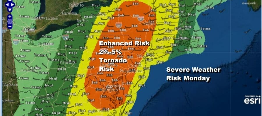
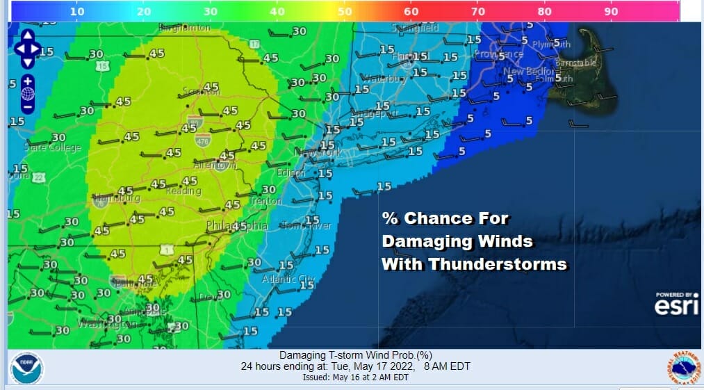
The Storm Prediction Center has an enhanced risk for severe weather across the Northeast and Mid Atlantic states today. The risk extends from Upstate New York southward to Northeast Virginia. This is also elevated tornado risk in the enhanced risk zone The biggest risk appears to be with strong wind gusts as this fast moving line of thunderstorms moves through. There is a large area where we have a high 45% chance for wind gusts of over 50 knots.
Expect thunderstorms to arrive around 4pm in Eastern Pennsylvania and Western New Jersey south to Maryland around 4-5pm reaching the coast around 6pm and east across Southern New England and Long Island shortly after 6pm The risk of severe weather decreases some east of NYC and Southern New England due to the usual spring impacts of the wind off the ocean but it doesn’t completely eliminate the risk thanks to the strong upper trough that is providing support.
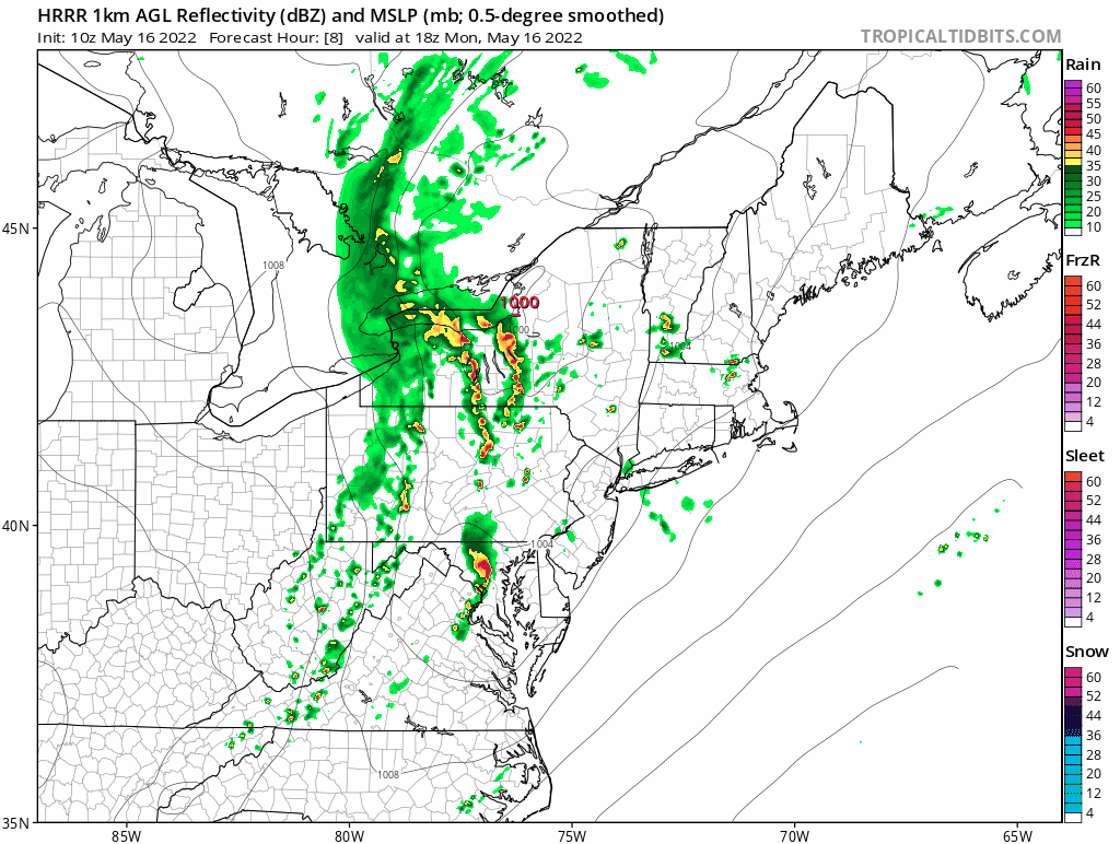
The HRRR model is showing two lines of thunderstorms. A lead and the more powerful line runs a head while the second line eventually weakens behind it. The loop starts at 2pm and shows hour by hour until 10pm. Notice the storms do weaken once they enter the coastal waters thanks to the cooler ocean which makes sense given the time of year.
SATELLITE

WEATHER RADAR

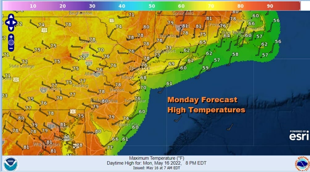
One of the keys to the development of these thunderstorms will be the daytime heating. We have dew points into the 60s which is juicing up the atmosphere. The satellite for now shows patchy clouds with large breaks so we should see sunshine heat things up into this afternoon. Highs will reach the upper 70s and lower 80s inland while it will be a few degrees cooler along south and east facing shorelines.
Once the storms are done winds shift to the northwest and drier air arrives tonight. Skies should at least partially clear with lows mostly in the 50s with a few 40s well inland. Tuesday we will see sunshine and a few clouds. It will be breezy at times. Highs will reach into the lower 70s. We should be dry through Wednesday. The next weather system approaches with sun and arriving clouds. Highs will be in the upper 60s and lower 70s. There could be a few showers Wednesday night and Thursday. We will be transitioning into a warmer pattern at the end of the week and we could actually have a dry mostly rain free weekend (other than scattered inland pm thunderstorms) for the first time in many months. In the meantime, thunderstorms are front and center and we will be airing the Joe & Joe Weather Show LIVE at 5pm due to the severe weather threat.
BE SURE TO DOWNLOAD THE FREE METEOROLOGIST JOE CIOFFI WEATHER APP &
ANGRY BEN’S FREE WEATHER APP “THE ANGRY WEATHERMAN!
MANY THANKS TO TROPICAL TIDBITS & F5 WEATHER FOR THE USE OF MAPS
Please note that with regards to any severe weather, tropical storms, or hurricanes, should a storm be threatening, please consult your local National Weather Service office or your local government officials about what action you should be taking to protect life and property.


