
DOWNLOAD MY NEW FREE JOESTRADAMUS WEATHER APP FOR ALL DEVICES
THE APP IS ABSOLUTELY FREE TO ALL BUT CONSIDERING SUBSCRIBING TO PATREON FOR A WEATHER EXPERIENCE FREE OF ADS, EXCLUSIVE VIDEOS FOR MEMBERS ONLY AND MUCH MORE…STARTS AT $2 A MONTH..MESSAGE ME AT ANY TIME
Early Call Snow Forecast Wednesday Night 02272019
We have a weak system that will be approaching for Wednesday night from the Midwest while at the same time a weak system will be coming out of the Eastern Gulf and moving off the Southeast US coast. The flow in the Atlantic remains like the express lane on a highway from Charleston to Lisbon Portugal so the southern low is not an issue here. It will be all about the northern low and how far south the southern edge of snow gets.
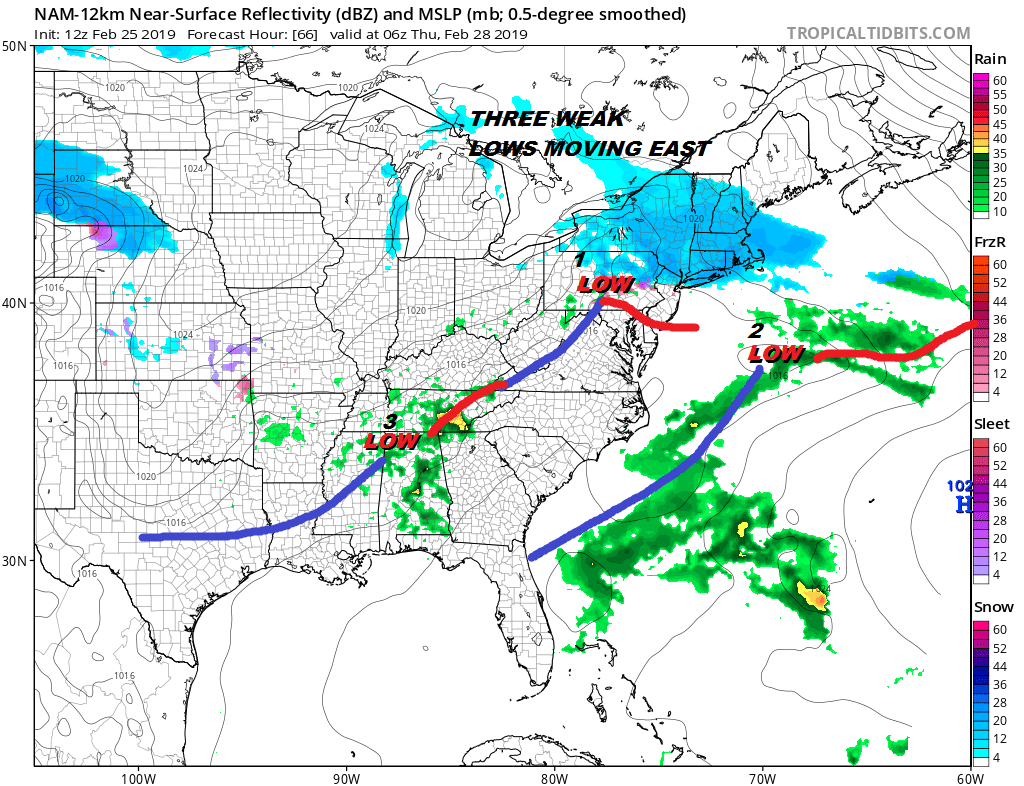
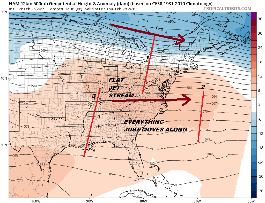
This map for 1am Thursday shows an area of snow with the southern edge just south of NYC. You can see the coastal offshore low moving out to the east and staying weak which so many have done this winter. The upper flow is just about as flat as a board and there is no amplitude at all to any of these systems.
It is really hard to get wrapped up over this as far as snow is concerned. I came up with a snow map for Wednesday night. The coating line could easily wind up where the 1 or the 2 inch line is. This seems to be a scenario where Eastern Connecticut and Eastern Long Island could get a bit more because of the tilt of the flow and how the precipitation shield moves east southeast. Note the sharp cut off of the zero line which lies from from near Sandy Hook to well north of Trenton.
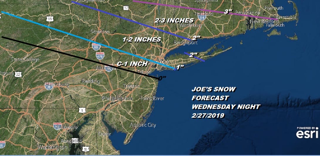
I’m probably too aggressive here but if you are going to give me a hard time about an inch of snow not happening then you probably have more issues than you realize! In the meantime we continue to blow away with the winds into this evening but the worst of it is behind us now and wind gusts should continue to slowly come down overnight though gusts of 30 to 40 mph will continue at least for awhile.
EASTERN SATELLITE

REGIONAL RADAR

We are still seeing snow squalls upstate coming off the Great Lakes. Those snow showers should continue into tonight and then gradually the snow machine will shut off during the day Tuesday. Temperatures tonight will drop into the low 20s with teens in cold spots and wind chills down in the single digits. Tuesday’s highs with sunshine and some clouds will be in the 30s. Wednesday look for increasing clouds with highs in the upper 20s to lower 30s. We will see a chance for some snow Wednesday night into Thursday from North Central Jersey north and eastward. Higher amounts will be in the Hudson Valley and interior Connecticut. The snow should be done by Thursday morning. System number 3 could bring some light snow or rain on Friday but we see that system being rather weak as well again due to the flatness of the flow. Another low comes out on Saturday (not on the map above) and that looks to be another one that basically slides off somewhere along the coast. That doesn’t really get resolved until we get rid of the lead lows. It is a weak convoluted weather pattern with inspires little confidence in the forecast overall.
MANY THANKS TO TROPICAL TIDBITS FOR THE USE OF MAPS
Please note that with regards to any tropical storms or hurricanes, should a storm be threatening, please consult your local National Weather Service office or your local government officials about what action you should be taking to protect life and property.


