Dry Warmer Weekend Underway Shower Chances Monday Into Tuesday

Weather in 5/Joe & Joe Weather Show Latest Podcast
Dry Warmer Weekend Underway Shower Chances Monday Into Tuesday

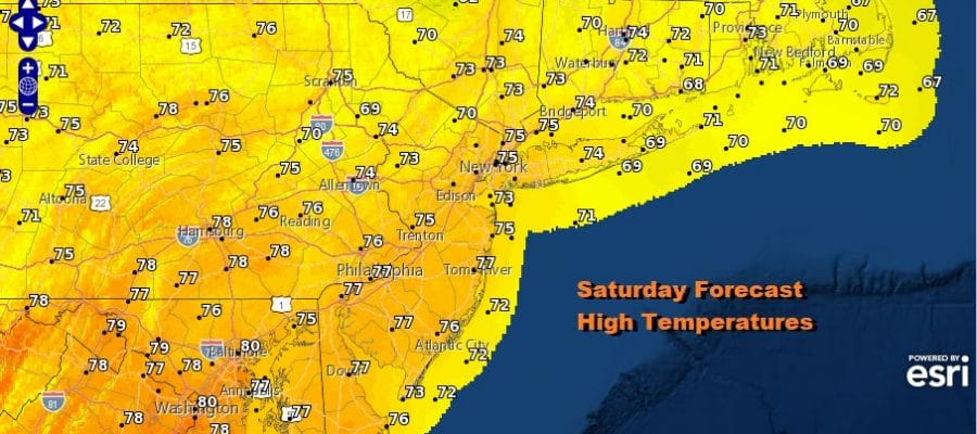
The weekend is here and it is going to be a solid start this Saturday as the satellite shows skies nice and clear from Central New England southward into the Southeastern US. On the far right is the western flank of Hurricane Sam as it makes its way northward and will turn northeast today on its way to the Atlantic graveyard for hurricanes. That leaves us with a sunny day with temperatures after a chilly start heading up into the 70s everywhere. There are no radar issues to worry about today and neither for tonight or Sunday.
SATELLITE

WEATHER RADAR

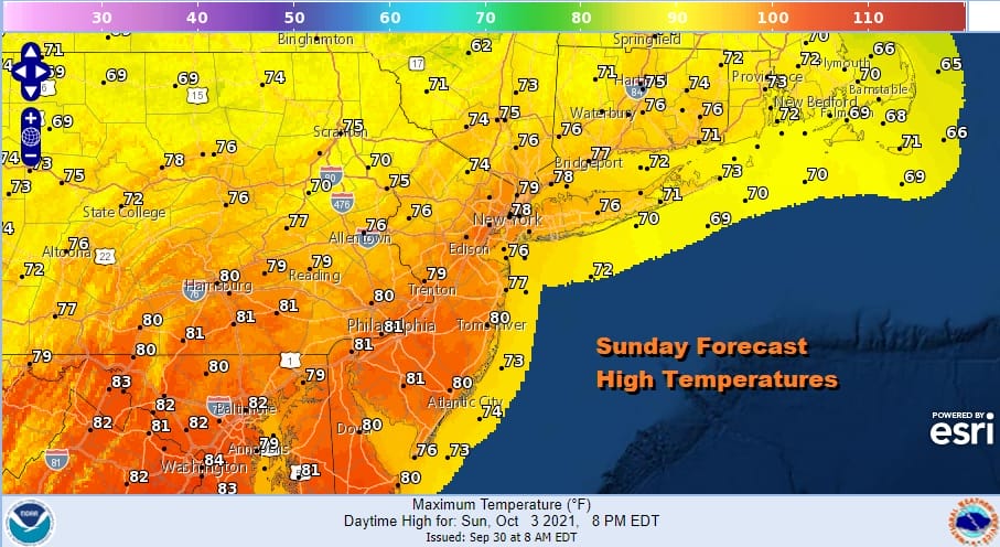
High pressure is along the Virginia Coast and will be moving slowly eastward. We are waiting for Hurricane Sam to move far enough east to break the weather system traffic jam over the US. They start moving again Sunday but it should be no worse than sun and arriving clouds. It will be a warm Sunday with highs reaching the upper 70s and lower 80s.
The next cold front slowly makes its approach Sunday night and Monday. This is not going to be in any rush to pass no is it a situation of widespread rain. Instead it will probably mean mostly cloudy conditions with the odd break or two of sun and risk for showers during the day Monday and also on Tuesday. Highs Monday will still be on the warm side in the 70s to around 80 degrees.

The front passes through Monday night and very slowly sinks southward and weakens. High pressure from Eastern Canada and Northern New England begins to build southward creating an onshore flow starting Tuesday and lasting all week. Once the wind turns northeast we will see temperatures edge a bit lower but this is not a cool air mass so we will still see temperatures be a little above average for this time of year. 70s for Tuesday and upper 60s to mid 70s on Wednesday. The onshore flow will likely mean that we will be in clouds for much of the time this week from Wednesday through Friday. Also along the coast there could be a few scattered showers or some drizzle from time to time. Some sun will be in the mix too especially inland. There are no major storms to worry, or any tropical storms or hurricanes either as the tropics take a bit of a break for next week. Attention may turn to the Northwest Caribbean next weekend as something tries to come out of that area and head northward but there is nothing to grasp on model wise that makes this a certainty or even a high chance of developing, at least for the time being. Enjoy the weekend.
BE SURE TO DOWNLOAD THE FREE METEOROLOGIST JOE CIOFFI WEATHER APP &
ANGRY BEN’S FREE WEATHER APP “THE ANGRY WEATHERMAN!

MANY THANKS TO TROPICAL TIDBITS & F5 WEATHER FOR THE USE OF MAPS
Please note that with regards to any severe weather, tropical storms, or hurricanes, should a storm be threatening, please consult your local National Weather Service office or your local government officials about what action you should be taking to protect life and property.


