Drought Relief Likely This Week
DROUGHT RELIEF THIS WEEK WITH WIDESPREAD RAIN WEDNESDAY NIGHT INTO FRIDAY
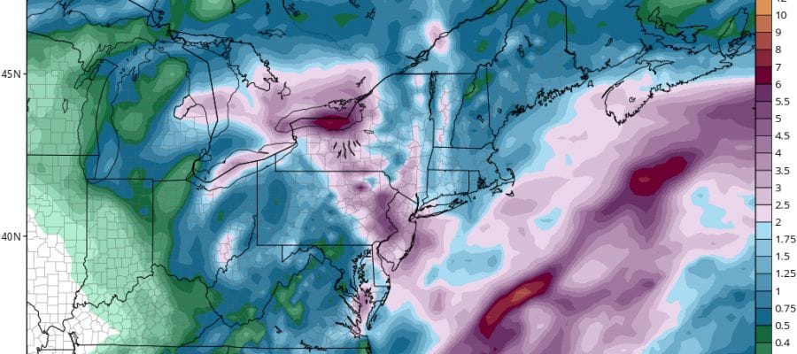
Tonight begins the first of several rounds of rain that we will be dealing with between now and Saturday. When we combine all the rainfall latest weather models are very bullish on 3 to 6 inches of rain over a wide area. Even if we want to be conservative on this, we could see every bit of 2 to 4 inches of rain over a large area.
DROUGHT RELIEF GFS RAINFALL FORECAST NEXT 7 DAYS
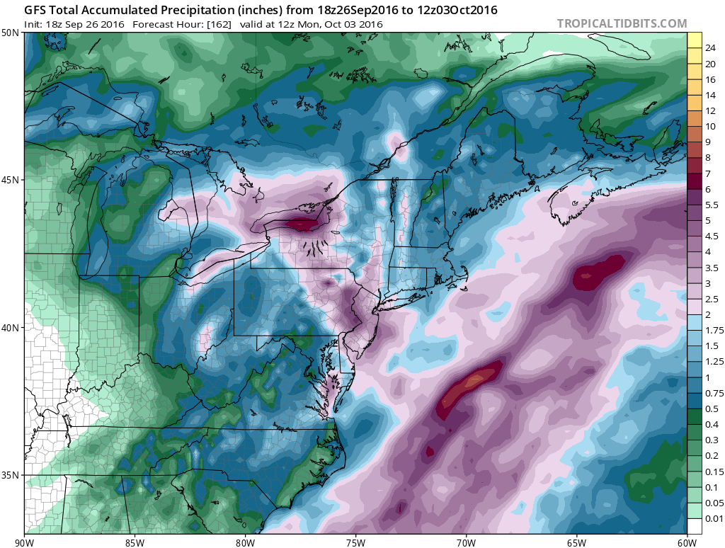
The latest GFS run this afternoon continues to grown even more bullish with total rainfalls as the map above shows. This is cumulative rain for the next 7 days. The model indicates a large area of 4 inch plus rains for New Jersey, Eastern Pennsylvania, the Hudson Valley and into the Western half of Long Island. Amounts decrease some further west and north but the rains are still on the order of an inch or two throughout all of the Northeast.
Tonight’s rain is the first shot and it won’t amount to too much. You can see on the satellite the large arm of moisture swinging around the strong upper air storm in the Great Lakes. Rain arrives in New Jersey shortly and spreads east to Long Island and Connecticut during the early morning hours. Rain could be still falling during the start of the Tuesday morning commute before it ends from west to east.
DROUGHT RELIEF SATELLITE LOOP


Weather conditions improve some Tuesday afternoon but clouds come back from the east and south during Tuesday night and Wednesday which sets us up for the next and more important shot of rain for later Wednsday and lasting into early Friday. We will have a strong southeast flow from off the ocean bringing in ample moisture around a developing low in Chesapeake Bay.

If we can’t get a couple of inches of rain out of this then it may as well never rain again! The upper air system responsible for this will still be hanging around into the weekend so more showers are likely into Saturday!
After that attention shifts to the tropics as a tropical storm is set to form in the Eastern Caribbean in the next few days. The weather system now is approaching the Windward Islands and continues to become better organize. We could have a tropical depression developing in the next 2 days and the National Hurricane Center now rates this possibility at 80%..and 90% over the next five days.

WINTER WEATHER OUTLOOK VIDEOS
In case you missed them I’ve been previewing the upcoming winter in a series of posts and videos. Here are the first 2. More will be coming along. Links to the latest posts are below.
EASTERN PENNSYLVANIA
NEW JERSEY
LONG ISLAND AND NEARBY
WINTER 2016-2017 PART 4 EASTERN PENNSYLVANIA
WINTER 2016-2017 PART 3 NEW JERSEY
WINTER 2016-2017 PART 1 OCEAN WATER TEMPERATURES
WINTER 2016-2017 PART 2 ARCTIC SEA ICE AND SIBERIAN SNOW COVER
FiOS1 News Weather Forecast For Long Island
FiOS1 News Weather Forecast For New Jersey
FiOS1 News Weather Forecast For Hudson Valley
NATIONAL WEATHER SERVICE SNOW FORECASTS
LATEST JOESTRADAMUS ON THE LONG RANGE

Weather App

Don’t be without Meteorologist Joe Cioffi’s weather app. It is really a meteorologist app because you get my forecasts and my analysis and not some automated computer generated forecast based on the GFS model. This is why your app forecast changes every 6 hours. It is model driven with no human input at all. It gives you an icon, a temperature and no insight whatsoever.
It is a complete weather app to suit your forecast needs. All the weather information you need is right on your phone. Android or I-phone, use it to keep track of all the latest weather information and forecasts. This weather app is also free of advertising so you don’t have to worry about security issues with your device. An accurate forecast and no worries that your device is being compromised.
Use it in conjunction with my website and my facebook and twitter and you have complete weather coverage of all the latest weather and the long range outlook. The website has been redone and upgraded. Its easy to use and everything is archived so you can see how well Joe does or doesn’t do when it comes to forecasts and outlooks.
Just click on the google play button or the apple store button on the sidebar for my app which is on My Weather Concierge. Download the app for free. Subscribe to my forecasts on an ad free environment for just 99 cents a month.
Get my forecasts in the palm of your hand for less than the cost of a cup of Joe!

MENTION JOE CIOFFI AND GET A 5% DISCOUNT


