
DOWNPOURS TONIGHT & TUESDAY
VERY WARM WEDNESDAY THROUGH FRIDAY
As we take a look at the weather going forward the radars are getting a little busy this evening. Radars are showing showers and some heavier downpours developing but for now they seem scattered in nature. They are moving northeast to southwest in response to the strong upper low to the south of us. Overnight rain from off the ocean will get involved so the will be some showers and downpours on and off tonight and Tuesday. Most areas won’t see them until after the evening commute is done.

The rotation of the upper low is very clear on the radar loops. It is the area out in the ocean that will provide a more widespread rain for a few hours assuming it holds together as it moves northwestward and inland.
DOWNPOURS TONIGHT & TUESDAY RADAR LOOP

DOWNPOURS TONIGHT & TUESDAY LOCAL RADARS


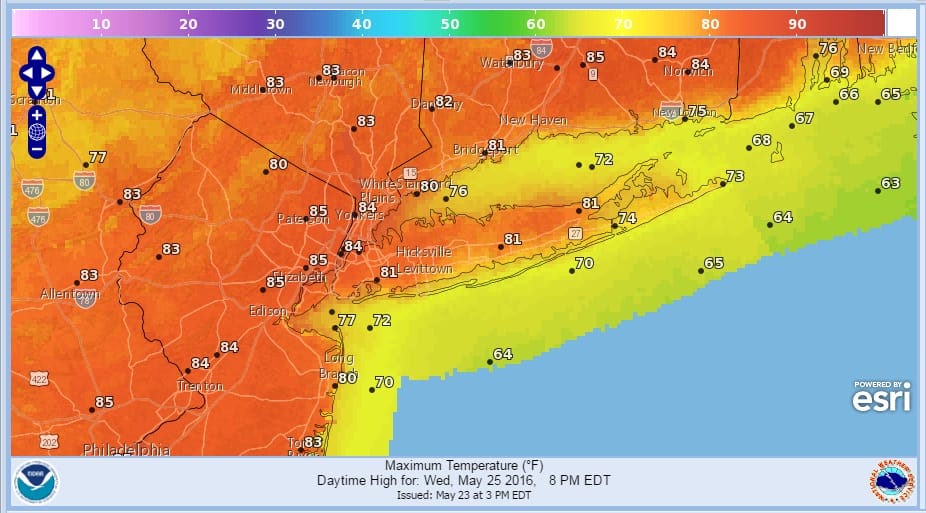
Gradually as we work through Tuesday showers will diminish and they should be gone by Tuesday night. Then get set for warm weather for the rest of the week. Wednesday is now looking especially warm with sunshine and a solid west wind. Temperatures should make the low to mid 80s just about everywhere. Even the coast should reach 80 before any sea breeze occurs.
Now for the weekend the big question will be Sunday night and Monday. There are two issue. The first is a backdoor cold front which the GFS model shows quite well. The new European model has come around to this idea as well. This could create conplications for Monday.
DOWNPOURS TONIGHT & TUESDAY GFS MODEL SUNDAY NIGHT
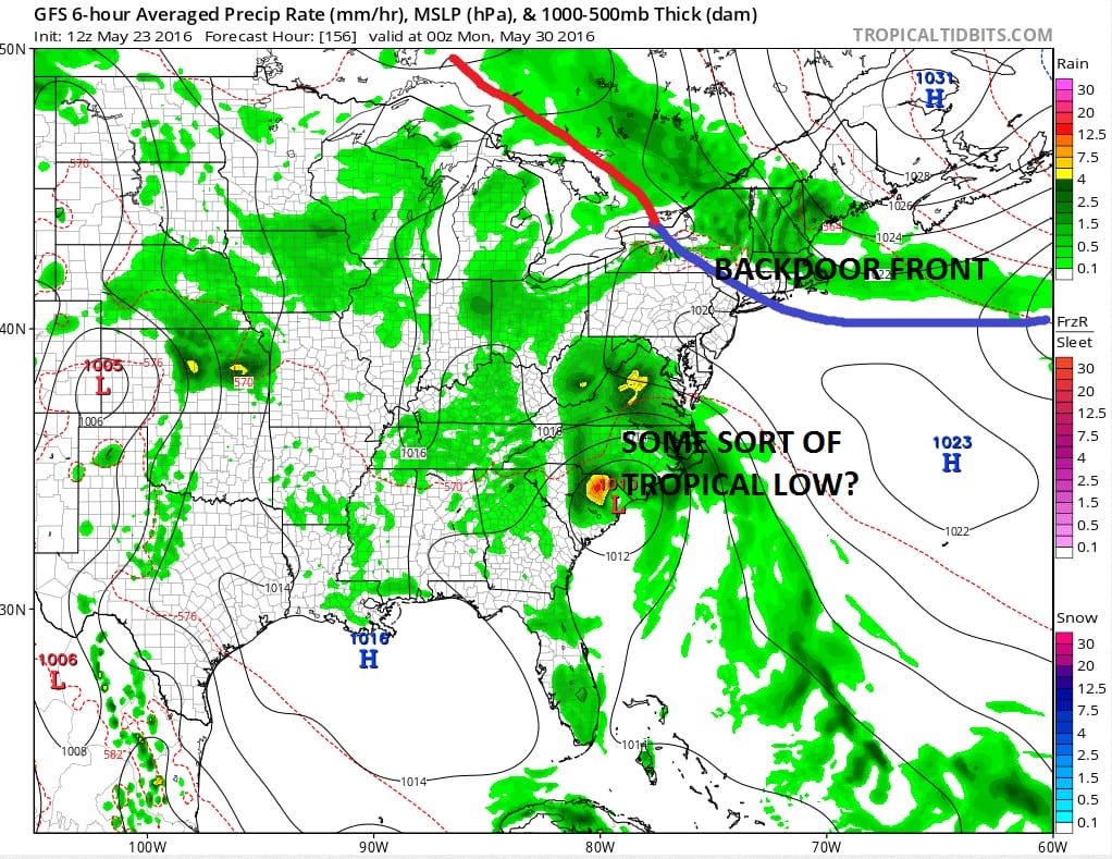
The second issue for early next week is low pressure that all weather models seem to develop in one form or another which when combined with the onshore flow, will mean clouds, cooler temperatures, and a question of whether there will be some rain nearby. For now we remain optimistic on Saturday and Sunday and agnostic on Monday. We will have more on this late this evening with a full model analysis.

MENTION JOE CIOFFI AND GET A 5% DISCOUNT
FiOS1 News Weather Forecast For Long Island
FiOS1 News Weather Forecast For New Jersey
FiOS1 News Weather Forecast For Hudson Valley
NATIONAL WEATHER SERVICE SNOW FORECASTS
LATEST JOESTRADAMUS ON THE LONG RANGE

NOMINATED FOR AN APPY AWARD FOR BEST WEATHER APP!!
Weather App

Don’t be without Meteorologist Joe Cioffi’s weather app. It is really a meteorologist app because you get my forecasts and my analysis and not some automated computer generated forecast based on the GFS model. This is why your app forecast changes every 6 hours. It is model driven with no human input at all. It gives you an icon, a temperature and no insight whatsoever.
It is a complete weather app to suit your forecast needs. All the weather information you need is right on your phone. Android or I-phone, use it to keep track of all the latest weather information and forecasts. This weather app is also free of advertising so you don’t have to worry about security issues with your device. An accurate forecast and no worries that your device is being compromised.
Use it in conjunction with my website and my facebook and twitter and you have complete weather coverage of all the latest weather and the long range outlook. The website has been redone and upgraded. Its easy to use and everything is archived so you can see how well Joe does or doesn’t do when it comes to forecasts and outlooks.
Just click on the google play button or the apple store button on the sidebar for my app which is on My Weather Concierge. Download the app for free. Subscribe to my forecasts on an ad free environment for just 99 cents a month.
Get my forecasts in the palm of your hand for less than the cost of a cup of Joe!
![]()


