Damp Start Another Shower Weather Improves & Warms
Damp Start Another Shower Weather Improves & Warms
We have a weak disturbance moving through this morning and most of the precipitation has now shifted to the east. There was a little bit of light snow inland and light rain near the coast overnight but it really didnt’ amount to much. The rest of the day we will probably see leftover clouds with perhaps another shower with temperatures in the raw and chilly 40s. However there some partial clearing going on well to the west this morning and that dry air could begin to arrive late this afternoon and this evening. Skies should completely clear out tonight with lows mostly in the 30s except some 20s in the chilliest spots.
US SATELLITE

REGIONAL RADAR

LOCAL RADAR NEW YORK CITY

LOCAL RADAR PHILADELPHIA


Everything remains on course for a warm up over the next several days in stair step fashion. Look for partly sunny skies Wednesday with highs back into the 50s. Thursday a weak front approaches and weakens so look for some sun and clouds with the risk of a shower late in the day. Highs will be reaching into the 60s in many areas except along the immediate coast with a wind off the ocean always problematic this time of year.
FRIDAY’S FORECAST HIGH TEMPERATURES
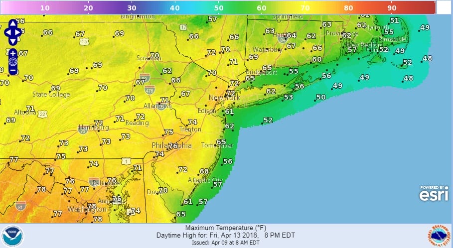
Friday is going to be nice with a front to our north and a west southwest wind. Temperatures will be getting into the 70s from NYC west and 60s to the east. We will also have a good deal of sunshine which will be great. Saturday’s plan continues to be highs in the 70s but a lot will hinge on whether a cold front “backdoors” its way southwestward from Eastern New England. Does front come through faster and further south than forecast at the moment? That is a critical question for Southern New England and Long Island; less so for New Jersey and Eastern Pennsylvania. Temperatures in Central and South Jersey will be in the 70s to perhaps even near 80. For now we will bet that the front holds off until late in the day Saturday or Saturday evening in which case 70s reach New England and Long Island. We need to watch this closely. Sunday will be cooler with cloudy skies and showers. A strong cold front triggers showers and thunderstorms later Sunday and on Monday with the potential for heavy rains.
 GET JOE A CIGAR IF YOU LIKE

FiOS1 News Weather Forecast For Long Island
FiOS1 News Weather Forecast For New Jersey
FiOS1 News Weather Forecast For Hudson Valley


