Core of Cold Air Exits Temperatures Bounce
Watching Storm For South & East Sunday Monday

Weather in 5/Joe & Joe Weather Show Latest Podcast
Core of Cold Air Exits Temperatures Bounce
Watching Storm For South & East Sunday Monday
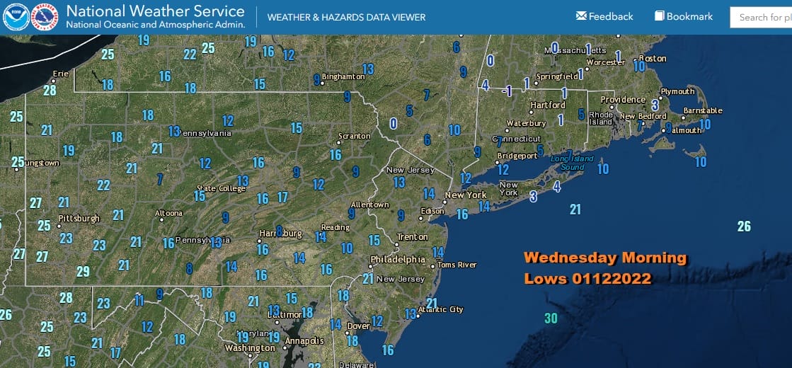
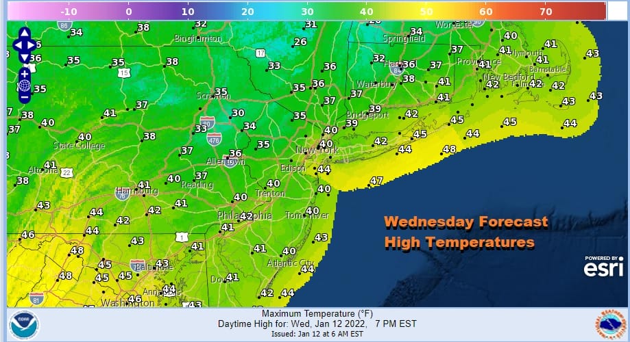
We hit bottom this morning as the core of the cold air mass settled overhead overnight. Some areas saw their winds drop off to calm or very light which allowed for some radiational cooling. Those areas made the single digits. Low to mid teens was the rule just above everywhere else. Now we are set to bounce higher today with sunshine. It doesn’t take long for temperatures to reflexively bounce back up to seasonal averages and that is exactly where we are headed today. Highs will be in the upper 30s and lower 40s and yes the sunshine will definitely be effective. It will also make you feel better.
There isn’t much happening on the satellite or the radar for today. There might be occasional passing clouds coming through from time to time. Other than that today will be a non event and the radars will be nice and quiet. In fact we really have no precipitation worries until later in the weekend as a storm heads our way from the Gulf States.
SATELLITE

WEATHER RADAR

With that in mind, we have a nice relatively warm night ahead of us tonight with mainly clear skies mixed with some high clouds. Lows will be in the mid 20s to around 30. Thursday looks to be a mild day with clouds and some sunshine. Highs will reach the low and middle 40s just above everywhere.
Changes get underway Friday as a storm develops just offshore and moves to the northeast. This storm was never going to impact us directly but it is the mechanism that will drive cold air back into the Eastern US for the weekend and set up the next storm that will be dropping southward out of the Plains and into the Gulf States. As the low moves northeast very cold air with high pressure will build across the Great Lakes and Southeastern Canada. The northerly flow around this large ocean storm will drag the cold air all the way down to the Deep South.
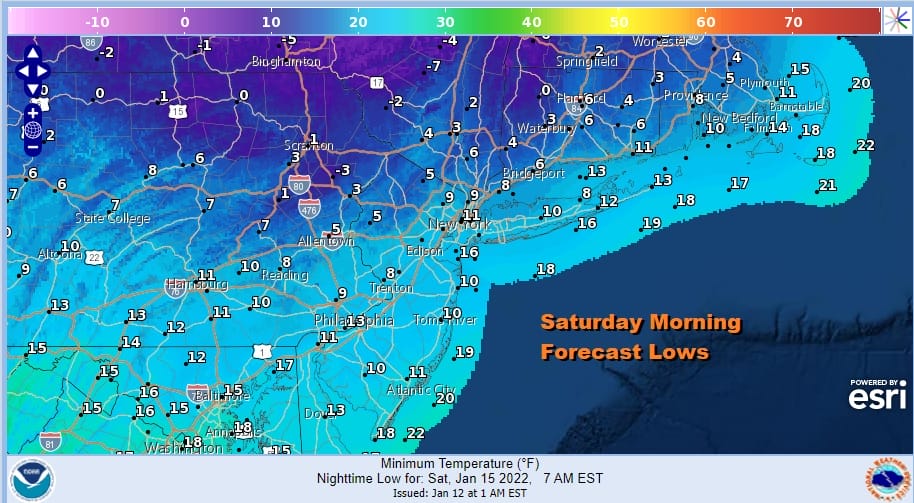
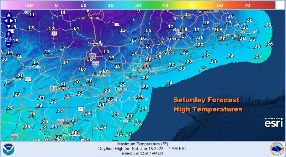
Friday’s highs will be in the 30s with clouds around until the storm pulls far enough east and then the north wind will blow and skies clear. By Saturday morning we will see temperatures down in the single digits and lower teens everywhere. Saturday look for some sunshine but it will be very cold. Highs will only be in the upper teens and lower 20s at best.
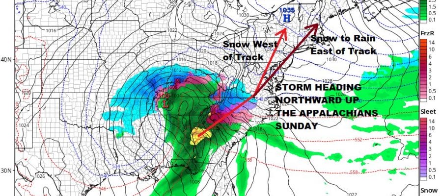
All of these actions are setting up a storm that is forecast to drop southward from the Plains and then move across the Deep South. Snow is going to fall for areas from Northern Mississippi and Alabama and heavy snow will fall from North Georgia, Eastern Tennessee eastward to the Carolina mountains into the Piedmont later Saturday and Saturday night, and then further north up the interior mid Atlantic and the interior Northeast later Sunday into Monday.
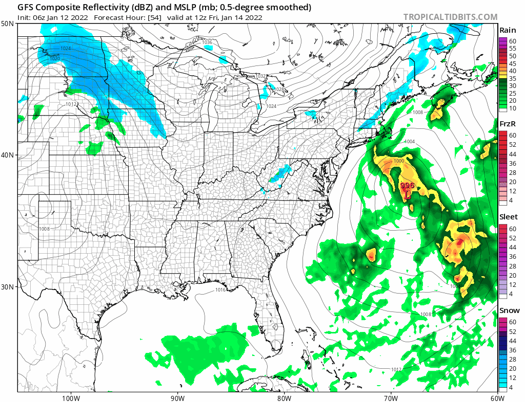
If we go straight with the GFS, which has gone so far left that the low runs up the east side of the Appalachians and cuts Pennsylvania in half, this is a no brainer. For the coast it would be mostly rain with a little snow or sleet at the start. Accumulating snow will be well inland north and west of the coast and the heaviest snows would be in the western half of Pennsylvania and Western and Northern NY. Eupven Albany and Central New England would go to rain. However I’m not quite sure that the far left GFS is correct here. Overnight the European run for example did not go further left from yesterday leaving us with a low running up the immediate coast with snow mainly north and west of the I-95 corridor though it was still rain along the coast. There are some other upper air issues that have me a little perplexed here. The blocking to the northeast is going to be key. Also I’m not quite convinced regarding the system that comes down from the Great Lakes and levers this northward and not northeastward. For now we leave you with the idea that this is a snow at the start to rain for most of the area, however I would like the option to leave the door open for another day or two to see this gets resolved differently.
BE SURE TO DOWNLOAD THE FREE METEOROLOGIST JOE CIOFFI WEATHER APP &
ANGRY BEN’S FREE WEATHER APP “THE ANGRY WEATHERMAN!

MANY THANKS TO TROPICAL TIDBITS & F5 WEATHER FOR THE USE OF MAPS
Please note that with regards to any severe weather, tropical storms, or hurricanes, should a storm be threatening, please consult your local National Weather Service office or your local government officials about what action you should be taking to protect life and property.


