
Very Cold Friday Night Into Sunday Morning Before Storm Rides Up the East Coast

Weather in 5/Joe & Joe Weather Show Latest Podcast
Very Cold Friday Night Into Sunday Morning Before Storm Rides Up the East Coast
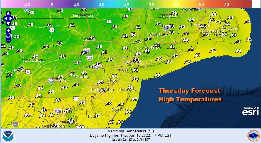
If we can manage some sunshine today temperatures this afternoon will reach the low and middle 40s. There are clouds moving east across the Great Lakes and Northeast ahead of an arctic front. There are also some showers showing up on the radar but they are mostly light and scattered around. That front will move through the Northeast and Northern Middle Atlantic states Friday morning and bring down colder air. The front will combine with a developing ocean storm to set the ball rolling for the next storm headed our way for later Sunday into Monday. Temperatures Friday will settle in the 30s to near 40 with clouds giving way to clearing skies later in the day and at night.
SATELLITE

WEATHER RADAR

On we go to Friday night into Saturday morning when cold air from Eastern Canada and New England reaches here. This air mass has its origins in Northern Labrador and up close to the North Pole so we are talking very cold air here. By Saturday morning we will see lows down in the single digits to low teens everywhere and the wind from the north will make it feel like it is below zero.
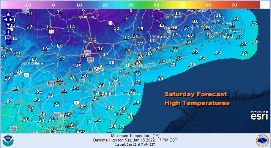
High pressure is going to build across the Northeast and that cold northerly flow continues right into Sunday morning. Don’t expect much in the way of a warm up on Saturday. Highs will just barely reach the upper teens and lower 20s and winds will still be on the gusty side from the north making it feel as if it is 10 degrees. colder or more. Obviously any sunshine we get Saturday will be completely ineffective.
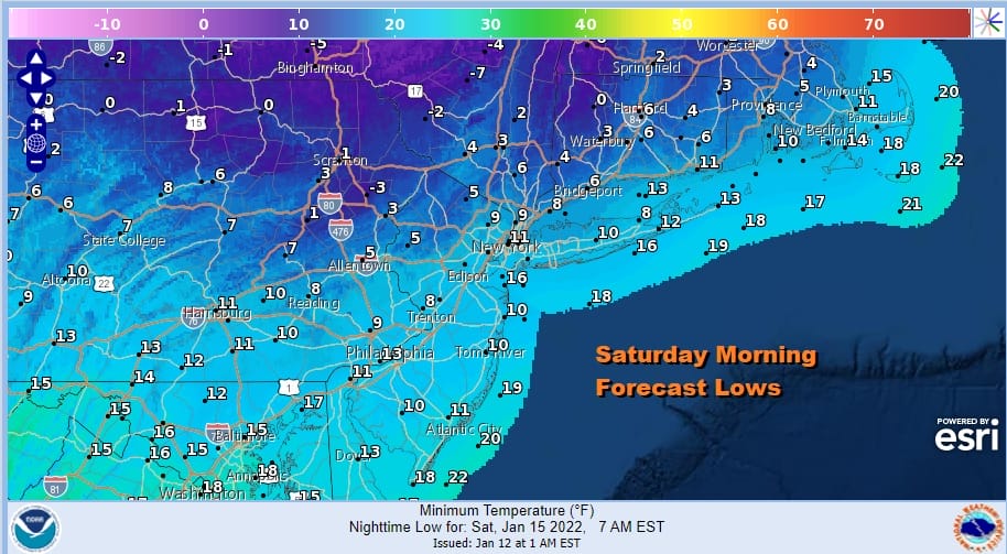
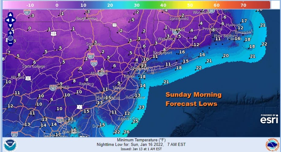
Another night of very cold weather is forecast for Saturday night into Sunday morning under clear skies. It will be every bit as cold as what we had Saturday morning with lows in the single digits to at best low teens. While it will still be breezy early in the night, winds should start to ease somewhat going into Sunday morning.
Now comes the challenging part of the forecast as low pressure moves across the Deep South Saturday and Saturday night and then makes the turn northeast through the Eastern Carolinas. All this cold air is going to wedge down the Eastern Seaboard and that is going to make for a heavy snow and ice storm for areas from North Georgia and Eastern Tennessee east and northeast through the Western Carolinas and on up into the western half of Virginia.

Normally because of a track through the deep south and then into the Eastern Carolinas this would be a snow storm for the Mid Atlantic coast and the Northeast but because we have no blocking in the North Atlantic or at best very little because it’s too far east, the cold high moves out and the low moves north and even north northwest tracking through East Central Pennsylvania Sunday night and then into Northeastern NY and Northern New England on Monday.

Following the track of the upper air storm, we see that the heavy snow potential area of 6 to 12 inches or even more lies inside the black lines. For the coast it becomes a matter of whether there could be some snow and areas inland as far west as I-81, it is a matter of how much falls on the front end before a change to rain occurs. Along the coast along the I-95 corridor south and east, I would expect very little at the beginning and then a quick change to a windswept soaking rain Sunday night into Monday morning before it all ends. As we start to work our way inland up to Route 84 and points northward, snow will accumulate more but it will also change to rain in these areas eventually Sunday night.
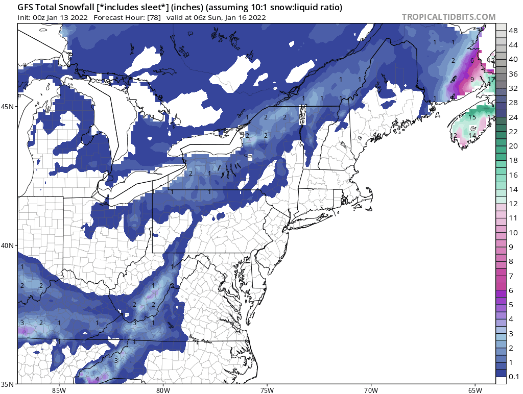
Normally I don’t put up snow maps here but I did today to illustrate where the heaviest snow will fall and how the coast gets little or nothing. The numbers on the map are meaningless but I would say there is a good chance that in the heavy snow areas in the greenish color that a foot or more of snow is possible while else where I would cut the amounts indicated back somewhat especially the one ones near the coast. Front end thumps are difficult to access and sometimes that can be quite productive but we won’t really have a handle on that until probably Sunday morning at the earliest. The storm ends Monday morning with windy and cold weather to follow.

We also want to point out for coastal residents that this weekend brings a full moon so this spells trouble for at least one high tide cycle and possibly two. The inland running storm means we are setting up for screaming easterly winds and a strong onshore flow later Sunday afternoon into early Monday morning. I would expect to see areas of moderate coastal flooding during high the high tides on Sunday. By morning Monday winds will have turned to the west and that will put an end to coastal flooding threats. Coastal New Jersey and the South Shore of Long Island stand to have the biggest issues regarding the high tides.
BE SURE TO DOWNLOAD THE FREE METEOROLOGIST JOE CIOFFI WEATHER APP &
ANGRY BEN’S FREE WEATHER APP “THE ANGRY WEATHERMAN!

MANY THANKS TO TROPICAL TIDBITS & F5 WEATHER FOR THE USE OF MAPS
Please note that with regards to any severe weather, tropical storms, or hurricanes, should a storm be threatening, please consult your local National Weather Service office or your local government officials about what action you should be taking to protect life and property.


