
Cold Winter Jackets Required Tonight Through Sunday
Cold winter jackets come out in the south once the temperature dips below 70. Such is the world we live in where the current climate is more like the deep south than the far north. Cold winter jackets will be seen this weekend for the first time in our area. We have been above normal on temperatures for every day this month and we have a chance to break that streak tomorrow depending on how much cloud cover and whether temperatures will break 40. It could still wind up being above normal on both weekend days but not by much.


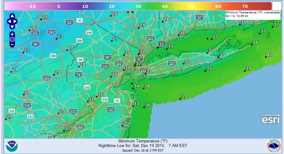
We had a second wave on the cold front keep us in clouds and even some showers were around in some places. However finally the dry air has taken over and we will have a rain free weekend. There is the possibility of snow flurries on Saturday with an upper air disturbance going by with the core of the cold air. Temperatures tonight will be in the mid 20s to low 30s. Saturday’s highs will be in the upper 30s to lower 40s. New York City has not gone below 32 yet so perhaps tonight will be the night. It will certainly be close.
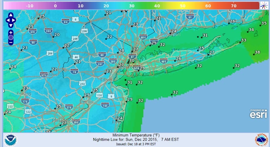
Saturday night will be clear and cold with lows in the 20s to low 30s. Sunday we should see a good deal of sunshine with highs in the low to middle 40s. Then on Monday with a southwest flow we should get back into the 50s everywhere before the next cold front comes through Monday night. That front is weak and only a spot shower is expected from that.
Tuesday and Wednesday we will start to see another storm come out of the southwest and head for the Great Lakes. Thie should set a warm front to our south and we should see rain develop here late Tuesday into Wednesday. Temperatures are going to be tricky depending on how strong an onshore flow sets up. 50s will be the pick for now on Tuesday. If the warm front goes north of us Wednesday we should reach upper 50s to lower 60s. Christmas eve the cold front will approach and there could be some showers at some point. Record breaking highs are possible as highs will be in the 60s everywhere. Cooler air and dry air should come in Christmas Day.
Cold winter jackets can be put away after Sunday based on this forecast. The long range forecast from JOESTRADAMUS deals with whether they will need to come out again anytime soon.
Video analysis of the Long Range models from earlier today
LATEST JOESTRADAMUS POST ON THE EUROPEAN MODEL

WEATHER APP
Winter is coming. Don’t be without Meteorologist Joe Cioffi’s weather app. It is a complete weather app to suit your forecast needs. All the weather information you need is right on your phone. Android or I-phone, use it to keep track of all the latest weather information and forecasts. This weather app is also free of advertising so you don’t have to worry about security issues with your device. An accurate forecast and no worries that your device is being compromised.
Use it in conjunction with my website and my facebook and twitterand you have complete weather coverage of all the latest weather and the long range outlook. The website has been redone and upgraded. Its easy to use and everything is archived so you can see how well Joe does or doesn’t do when it comes to forecasts and outlooks.
Just click on the google play button or the apple store button on the sidebar for my app which is onMy Weather Concierge. Download the app for free. Subscribe to my forecasts on an ad free environment for just 99 cents a month.
Get my forecasts in the palm of your hand for less than the cost of a cup of Joe!

![]()


