Cold Night Ahead Nice Sunday Next Front Monday Next Storm System Thursday Friday

Weather in 5/Joe & Joe Weather Show Latest Podcast
Cold Night Ahead Nice Sunday Next Front Monday Next Storm System Thursday Friday
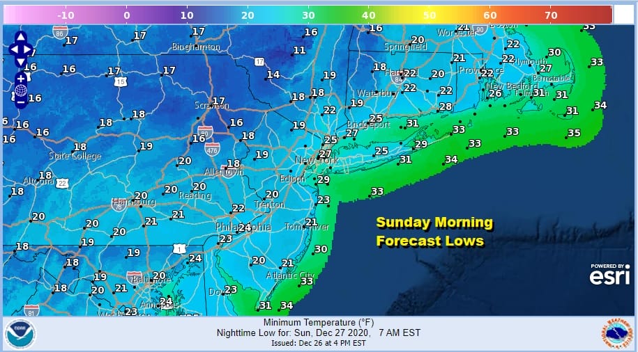
The story today was cold air that came in on the back of yesterday’s cold front. It was a nice day though somewhat breezy but we had sunshine and that was a good thing. We topped into the 30s and now we are headed for a cold night of clear skies. Morning lows will be generally in the upper teens to mid 20s.
Lake effect snows were working overtime today on the lee shores of Lake Ontario with Buffalo getting its first major double digit snowfall of the winter as well as some areas in North Central NY getting in on the action. However the radars near by are quiet. Some patchy clouds are still hanging about inland but they should thin out overnight. No snow is expected in our region overnight with some snow showers up in the Catskills and points north.
SATELLITE

Moving on to Sunday it will be a nice sunny day as high pressure moves overhead. Temperatures will reach the upper 30s to around 40 degrees with less wind. Temperatures Sunday night into Monday morning will hold in the upper 20s to mid 30s as winds turn southwest ahead of the next cold front which is due to arrive later Monday.

The logic of the forecast remains unchanged for Monday through Wednesday. The cold front has little action with it other than clouds so we go for a mix of sun and clouds Monday with highs in the 40s. Colder air follows for Tuesday and Wednesday which will be similar to day and Sunday. Tuesday will be cold with sunshine. Highs will be in the low to mid 30s. Wednesday’s highs will be in the 30s to near 40.
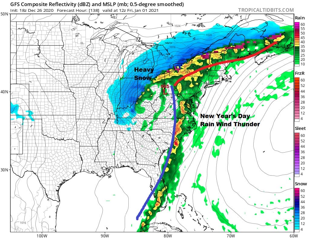
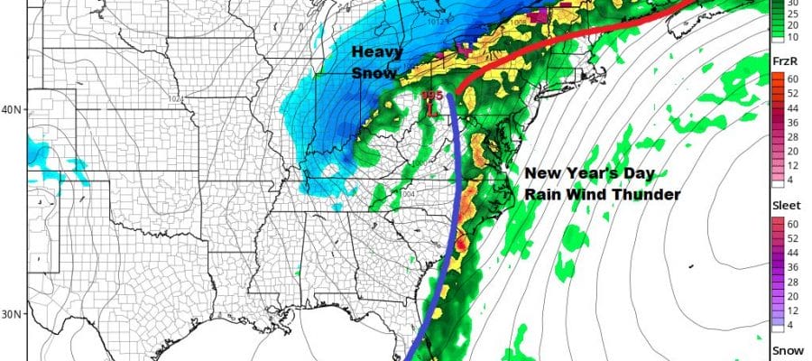
Though we have yet to work out the exact timing, New Year’s Eve and New Year’s Day will be a repeat performance of Christmas Eve and Christmas Day with rain wind and thunderstorms. It is hard to say whether the winds will be as strong as they were Christmas Eve night. The models are tracking the primary low further west this time around and the pressure gradient looks a little less formidable.
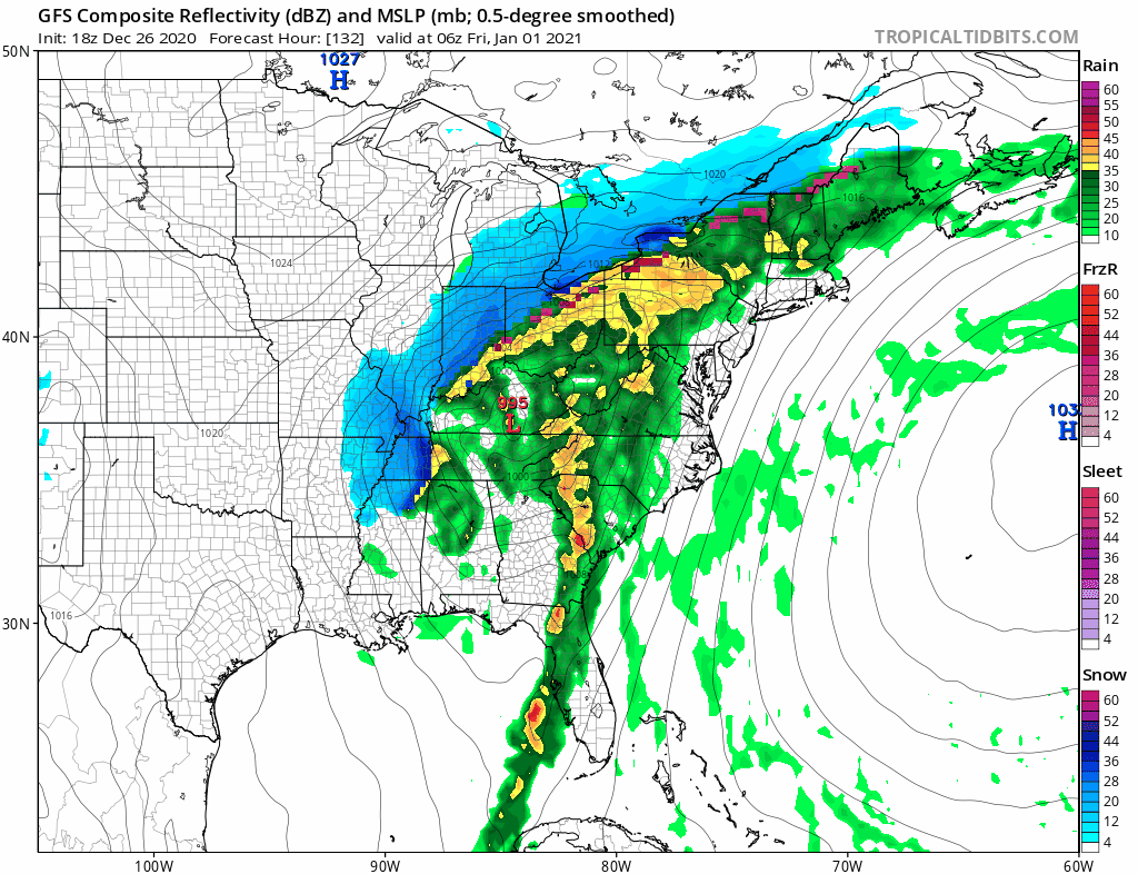
New Year’s Eve will see deteriorating weather conditions with showers and some heavy downpours Thursday night into Friday New Year’s Day. Temperatures will rise through the 50s and probably head into the 60s again briefly for early New Year’s Day before the front passes. Some thunderstorms could be in the mix. Rainfall amounts of a couple of inches again which means flooding issues possible. At least this time around there are no snow melt issues since the Christmas Day storm took care of that. Dry and colder weather will be with us next weekend.
BE SURE TO DOWNLOAD THE FREE METEOROLOGIST JOE CIOFFI WEATHER APP &
ANGRY BEN’S FREE WEATHER APP “THE ANGRY WEATHERMAN!
MANY THANKS TO TROPICAL TIDBITS FOR THE USE OF MAPS
Please note that with regards to any severe weather, tropical storms, or hurricanes, should a storm be threatening, please consult your local National Weather Service office or your local government officials about what action you should be taking to protect life and property.


