
Cold Front Finally Arrives Very Chilly Sunday Week Ahead Questions &
New Tropical Storm Possible

OMNITRUEVALUE.COM
Weather in 5/Joe & Joe Weather Show Latest Podcast
The weekend is underway and we finally have some movement in the flow across the Northeast and Mid Mid Atlantic states. To the east is very large Hurricane Epsilon which is on the edge of the frame of the satellite picture. Large swells and rip currents will be occurring up and down the coast this weekend. More importantly it is moving and it is turning to the northeast. It has been an effective block all week long keeping us in a rather doom and gloom type of weather pattern. However now that it is moving along to the east, weather systems can move from west to east across the US. A cold front just to the west will be the first of several fronts we will have to deal with in the next week to 10 days.
SATELLITE

REGIONAL RADAR

In the meantime the lead cold front doesn’t have much with it other than some scattered showers and they are being picked up on the local radars. The area of showers such as it is will weaken further as the day goes on. Look for a wind shift to the northwest. Clouds will linger into and through the afternoon though we should see some partial clearing from northwest to southeast perhaps late in the day.
LOCAL RADAR NEW YORK CITY

LOCAL RADAR PHILADELPHIA


The partial clearing trend lasts into tonight as our cold front continues to push southward but it will slow down and eventually stall out across the Middle Atlantic states. Temperatures by morning will drop into the upper 30s to mid 40s in most places.

Sunday you will notice on the temperature map has an upside down nature to it. That is because south and west of Philadelphia there will be lots of clouds Sunday and some rain will be moving northward from Maryland and Delaware into Southern Pennsylvania and Southern New Jersey. This is why we see many inland areas not getting out of the 40s. North and east of Philadelphia and NYC we might see a partly sunny start to the day with clouds creeping in later on. Temperatures there will reach 50 to 55 for highs.

Some rain will move northward Sunday night and into New England early Monday leaving the rest of the area in lots of clouds. Highs will be in the low to mid 60s. The loop of the radars on the GFS model for next week show the unsettled nature of the pattern for the week ahead.

Matching the jet stream up to that surface we see the northern jet active and moving, a ridge off the Southeast US coast to start the week and an approaching system in the southern jet that attempts to phase with the north late this week.
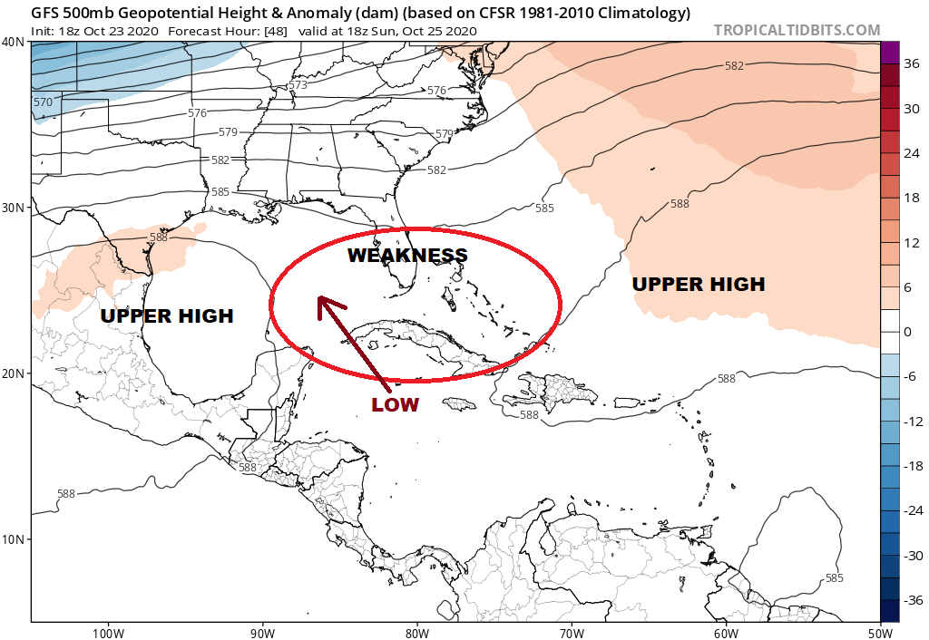
The southern part of this is intriguing because the upper high is split in two with a weakness in the Eastern Gulf of Mexico. Low pressure develops in the Northwest Caribbean will likely head for that weakens and then get picked up by the upper level westerlies across the Gulf States. With energy to the north getting involved it is conceivable that the rain from this system heads up the east coast late this week regardless of whether we get a tropical storm out of this or not. The National Hurricane Center has a 90% chance of tropical cyclone formation in the next 48 hours. It will be a rather challenging week from a forecast standpoint. Another front approaches Monday night with perhaps a few showers and yet another for mid week which will likely set up the Caribbean/Gulf system in some way.
BE SURE TO DOWNLOAD THE FREE METEOROLOGIST JOE CIOFFI WEATHER APP &
ANGRY BEN’S FREE WEATHER APP “THE ANGRY WEATHERMAN!
MANY THANKS TO TROPICAL TIDBITS FOR THE USE OF MAPS
Please note that with regards to any severe weather, tropical storms, or hurricanes, should a storm be threatening, please consult your local National Weather Service office or your local government officials about what action you should be taking to protect life and property.


