Cold Dry Into Early Saturday Sleet Freezing Rain Into Sunday
Stronger Storm System Tuesday

Weather in 5/Joe & Joe Weather Show Latest Podcast
Cold Dry Into Early Saturday Sleet Freezing Rain Into Sunday Stronger Storm System Tuesday
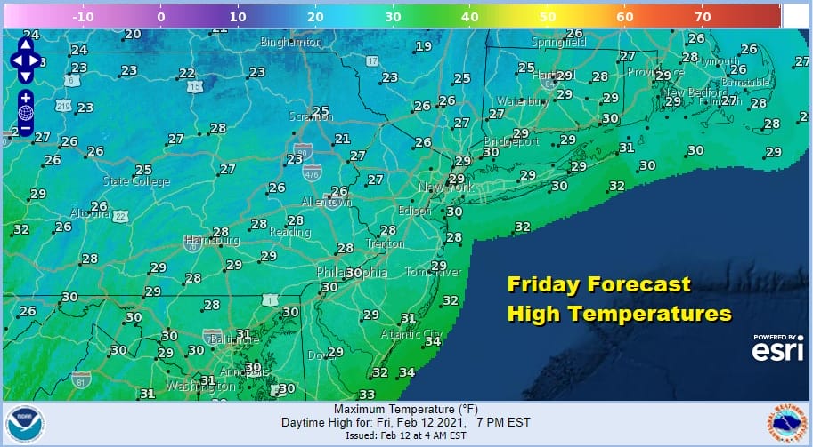
Colder air remains in place across the Northeast and Northern Mid Atlantic states. We see low pressure moving off the Virginia coast and it is pulling cold air southward out of Eastern Canada. The result is that we have a day of sunshine and clouds with high clouds as you head south. Temperatures today in most areas from Southern New England and the Hudson Valley to the Northern Mid Atlantic states will not get out of the 20s
Another cold night follows under mainly clear skies with most lows in the teens. Cold spots will be in the single digits. The satellite picture below shows the cloud cover over Virginia and in Coastal Virginia this is producing accumulating snow in some areas.
SATELLITE

The regional radars are picking up the last bands of snow that have moved across Virginia overnight and those areas continue to push off to the east. There are no issues from snow either today or through much of the daytime Saturday.
F5 WEATHER RADARS


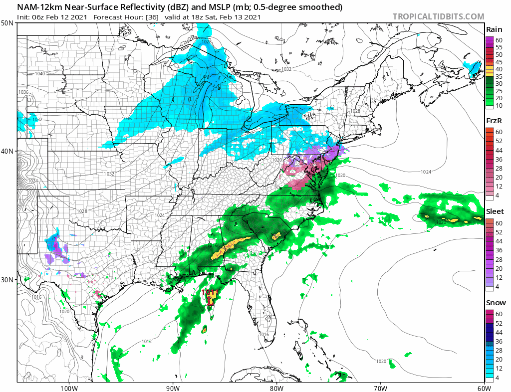
Let’s get the ball rolling for the weekend and into next week as we have a weak system coming up for Saturday night into Sunday. Another weak system will linger around on Monday and then we have a stronger system for later Monday night and Tuesday. So let’s deal with these one at a time.
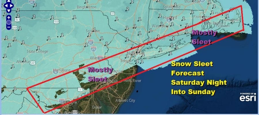
Saturday we will cloud up quickly and low pressure coming up from the south will likely produce some snow and sleet. Some areas will a see sleet and freezing rain. There is the risk for ice accretion into Sunday morning and the first forecasts are out for this. Expect these numbers to adjust higher later today as we get a handle on how much precipitation is actually going to fall.
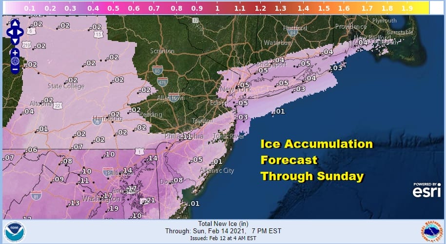
Some areas especially inland could see a little bit of snow out of this but for most areas it looks to be on the order of a coating to an inch or so. I’m more concerned about any kind of freezing rain sleet combination.
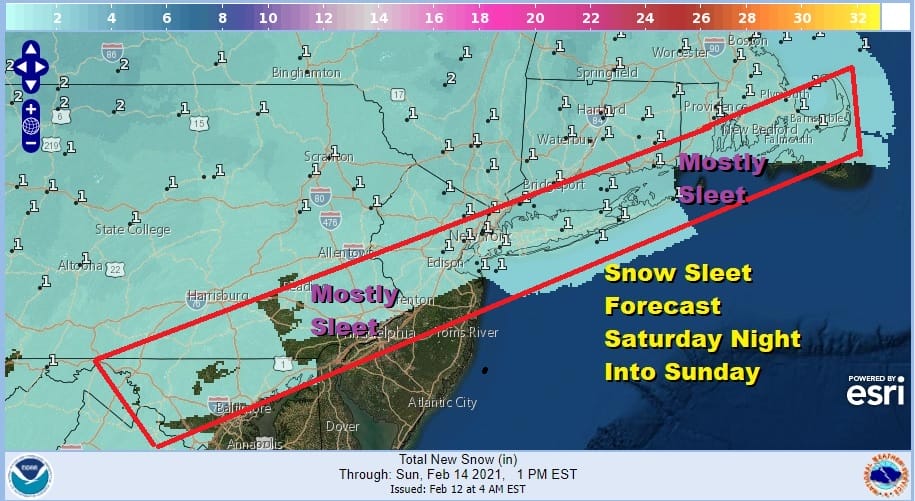
There is a second wave to the south that could bring some more on and off precipitation Sunday night into Monday. Temperatures will be tenuously close to freezing so it will be a matter of watching the thermometer straddle that 32 degree line.

Monday night into Tuesday it will be all about the stronger system and whether the primary low that heads for West Virginia into Southeast Ohio and does it hold enough long enough or does the secondary develop and take over. That will be the difference regarding rain sleet and snow. The GFS splits the difference and has a mostly sleet storm along the coastal plain with snow inland. This occurs Monday night into Tuesday morning. Weather conditions and cleanup will ensue after that. Given the nature of the weekend systems which will drive forecasters crazy, we will stay focused on that first and then move on to Monday night into Tuesday.
BE SURE TO DOWNLOAD THE FREE METEOROLOGIST JOE CIOFFI WEATHER APP &
ANGRY BEN’S FREE WEATHER APP “THE ANGRY WEATHERMAN!

MANY THANKS TO TROPICAL TIDBITS & F5 WEATHER FOR THE USE OF MAPS
Please note that with regards to any severe weather, tropical storms, or hurricanes, should a storm be threatening, please consult your local National Weather Service office or your local government officials about what action you should be taking to protect life and property.


