Dry Cold Friday Saturday Ice Issues Saturday Night Into Sunday Morning

Weather in 5/Joe & Joe Weather Show Latest Podcast
Dry Cold Friday Saturday Ice Issues Saturday Night Into Sunday Morning
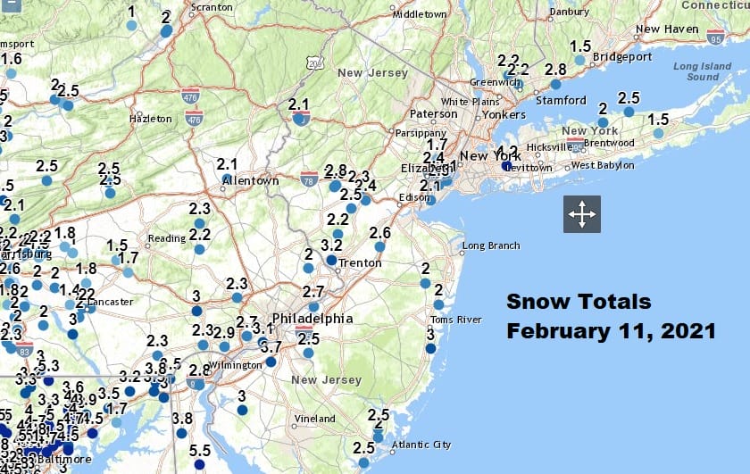
The overnight system played out according to plan with a few isolated areas in Central and South Jersey outperforming but most areas performed in line with expectations. This snowfall now puts just about everyone at above average snowfall for the entire winter.
It is a little difficult to separate the clouds from the snow cover but areas to the north around NYC and Southern New England managed a little sun today however to the south across Southern Pennsylvania and Southern New Jersey southward, clouds remain stubborn. There is another system that will be bringing some snow and sleet to Central and Southern Virginia tonight into Friday morning but this system will pass well to our south.
SATELLITE

The Mid Atlantic regional radar is seeing some action this evening and overnight as that disturbance to the south crosses Southern Virginia and head out to the east. The local regional radar is picking up a few snow showers in Western NY but not much else.
F5 WEATHER RADARS


A cold night lies ahead with clearing skies except for clouds in southern areas as mentioned earlier. Lows by morning will be in the teens and inland areas north and west of the coast could see some single digits by morning. Two cold days are head with some sunshine north and clouds south on Friday. Highs will be in the 20s to around 30. Then it is back down to the teens and some single digits Friday night into Saturday morning.

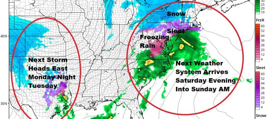
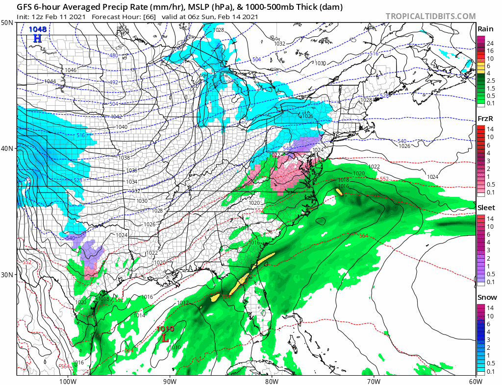
Saturday begins a set up for the next storm system that will be heading our way. This low will pass to the south and east. Weather models show a rather weak system here but what is more important is how much precipitation it will produce and the state of the lower atmosphere when that precipitation arrives later Saturday and continues into Saturday night.
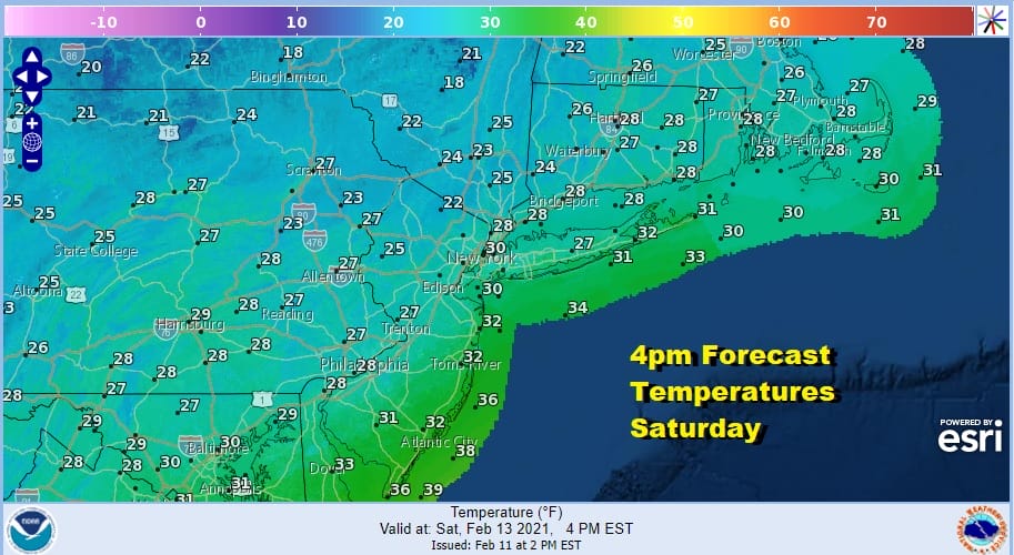
An early look at forecast temperatures at 4pm Saturday shows temperatures in the 20s just about everywhere except right along the immediate coast. Those temperatures don’t change much overnight as we see readings barely budging. All of this will be during a time when precipitation will be overhead.
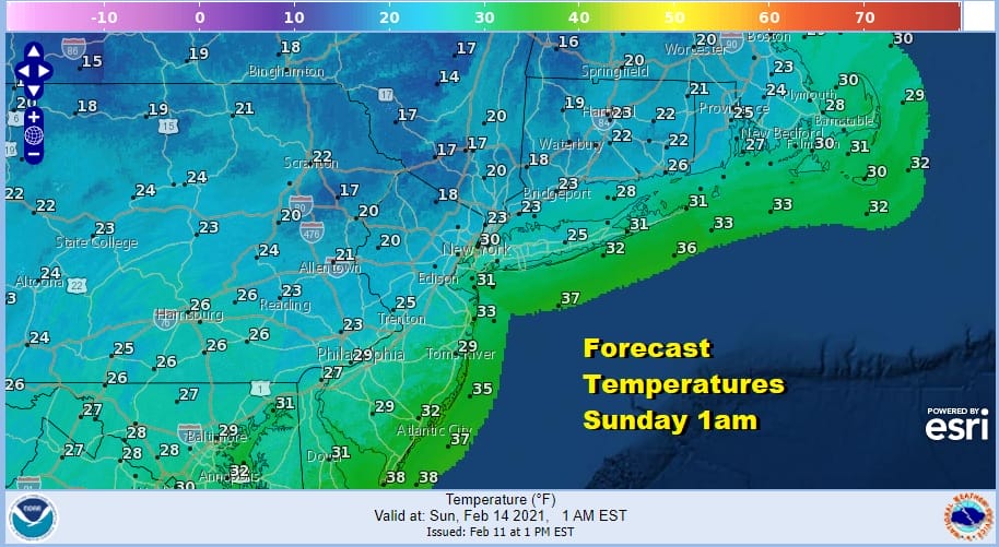
A quarter to perhaps a third of an inch of liquid precipitation is indicated for Saturday night and with a nose of warm air pushing in at about 500 ft, it is likely that we will see some freezing rain and some sleet. It would be enough to cause icing over a large area of the Northern Mid Atlantic to Southern New England. With temperatures close to critical levels it makes it had to figure how much snow falls in all of this. The ideal solution would be snow or sleet with any freezing rain on top of that. Freezing rain from the get go would be far worse and more dangerous outcome especially for roadways.
Lingering clouds and lingering areas of sleet or freezing rain will be around in some areas into Sunday night. The next storm system will be revving up for Monday night and Tuesday. Low pressure will attempt to go north up the Appalachians before a secondary develops and takes over. How fast that secondary forms will be key to this potential snow sleet freezing rain event. This system does look to be stronger than the one for Saturday night as there is a sharp short wave trough that is supporting this system Another storm lies in wait for later next week.
BE SURE TO DOWNLOAD THE FREE METEOROLOGIST JOE CIOFFI WEATHER APP &
ANGRY BEN’S FREE WEATHER APP “THE ANGRY WEATHERMAN!

MANY THANKS TO TROPICAL TIDBITS & F5 WEATHER FOR THE USE OF MAPS
Please note that with regards to any severe weather, tropical storms, or hurricanes, should a storm be threatening, please consult your local National Weather Service office or your local government officials about what action you should be taking to protect life and property.


