Winter Weather Advisory New Jersey South of Route 78 SE Pennsylvania

Weather in 5/Joe & Joe Weather Show Latest Podcast
Winter Weather Advisory New Jersey South of Route 78 SE Pennsylvania
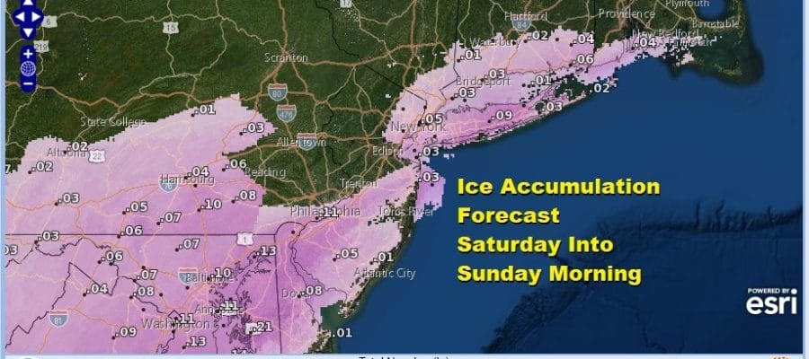
The first Winter Weather Advisories are up for New Jersey south of Route 78 into Southeastern Pennsylvania. More than likely we will see additional advisories go up for Northern New Jersey, the Hudson Valley, NYC, Long Island, and Connecticut either later tonight or they will go up Saturday morning. The issues this time will be sleet and freezing rain rather than snow as the upper atmosphere warms with temperatures in the 20s at ground level. This is for later Saturday into Saturday night and early Sunday.
SATELLITE

Clouds rolled back in today thanks to a disturbance that has moved off the Virginia coast and the approaching weather system for the weekend. The radars however are quiet and should remain so overnight before they start to rev up again on Saturday.
F5 WEATHER RADARS


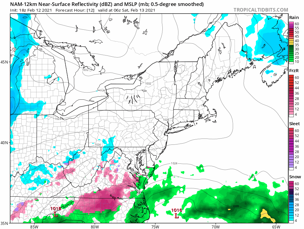
Precipitation will develop over Maryland and Virginia Saturday morning and push northward during the afternoon, reaching Southern New England by late afternoon or evening. Notice on the NAM model (as well as others) we have the purple color which is sleet. Also in the mix will be some freezing rain and drizzle and perhaps a few snowflakes.
Fortunately the bulk of the precipitation is offshore otherwise this would be a far worse situation. However we will see .10 to .15 of melted liquid which would be enough to produce up to a tenth of an inch of ice accumulation in some places. With temperatures in the 20s, this will create very slippery conditions over the area into Sunday morning. Most of the precipitation will be done by daybreak. There could however be leftover freezing drizzle around into Sunday afternoon.

Temperatures will inch higher Sunday afternoon into the upper 20s and lower 30s. Not much happens Sunday night into Monday though there could be pockets of freezing drizzle inland. Otherwise we sit back and wait for the next storm system for Monday night into Tuesday. That will bring snow sleet freezing rain and rain to the area though who gets what and when still remain uncertain.
BE SURE TO DOWNLOAD THE FREE METEOROLOGIST JOE CIOFFI WEATHER APP &
ANGRY BEN’S FREE WEATHER APP “THE ANGRY WEATHERMAN!

MANY THANKS TO TROPICAL TIDBITS & F5 WEATHER FOR THE USE OF MAPS
Please note that with regards to any severe weather, tropical storms, or hurricanes, should a storm be threatening, please consult your local National Weather Service office or your local government officials about what action you should be taking to protect life and property.


