Coastal Storm Gets Underway Wind Rain Coastal Flooding
Flash Flood Watch Northeast NJ, Wind Advisory Coastal NJ
Coastal Flood Advisory Long Island New Jersey Connecticut

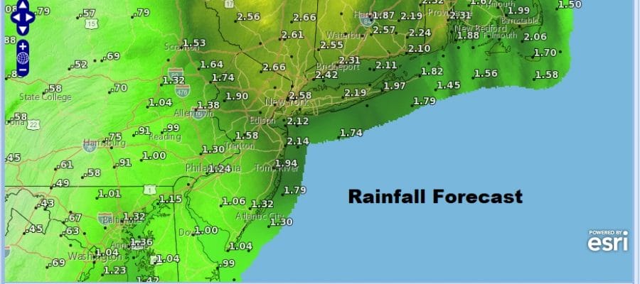
Weather conditions will deteriorate today from south to north as we are already seeing radars loading up to the south of NYC & Philadelphia. We will see heavy rain and a few thunderstorms going into tonight as low pressure develops along the Carolina coast and moves northward up the coast. 2 inches of rain or more is forecast from Northern New Jersey to Long Island and Southern New England with 1 to 2 inches as you go south and west of there. Winds will increase from the southeast to south along the coast to 20 to 30 mph with higher gusts. The evening commute will be a mess with heavy rain going on. Coastal flooding is an issue today for the high tides this evening but this should be the last tide cycle before winds turn to the northwest and coastal flooding risks subside.
SATELLITE

REGIONAL RADAR

Regional radar is loaded with rain now advancing rather quickly northward through Virginia and North Carolina and it should be here soon enough. Some areas of heavy rain are embedded in the mix here. This is going to be the first area wide rain event since back in the spring.
LOCAL RADAR NEW YORK CITY

LOCAL RADAR PHILADELPHIA


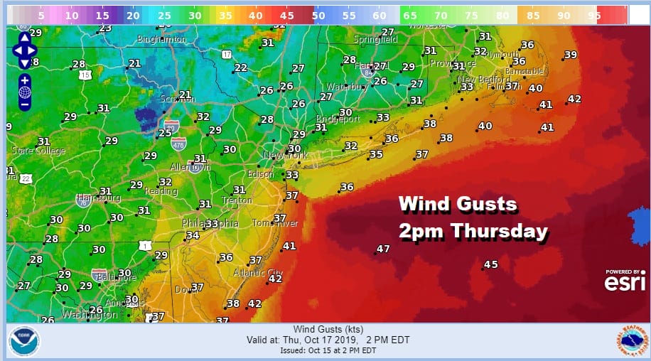
The rain will end tonight from southwest to northeast from 8pm to midnight. The Yankee Astros game is likely to be postponed. After midnight winds turn to the northwest and become strong and gusty overnight and Thursday with leftover clouds and a few passing showers. Temperatures will be in the 60s today and in the 50s at best for Thursday. Wind advisories are posted for the coastal counties of New Jersey and we will likely see additional advisories posted for other areas later today or Thursday.W
Weather conditions will improve Friday with sunshine and highs again in the 50s with diminishing winds. Saturday and Sunday for now look good with sunshine Saturday and sun and high clouds for Sunday with temperatures back into the 60s. A possible low in the southwest Gulf of Mexico is being monitored by the National Hurricane Center for possible development over the next several days. Some of that moisture could move into the Southeast US over the weekend and try to push northward so we will be watching and evaluating this once today’s storm plays through the area.
MANY THANKS TO TROPICAL TIDBITS FOR THE USE OF MAPS
Please note that with regards to any severe weather, tropical storms, or hurricanes, should a storm be threatening, please consult your local National Weather Service office or your local government officials about what action you should be taking to protect life and property.


