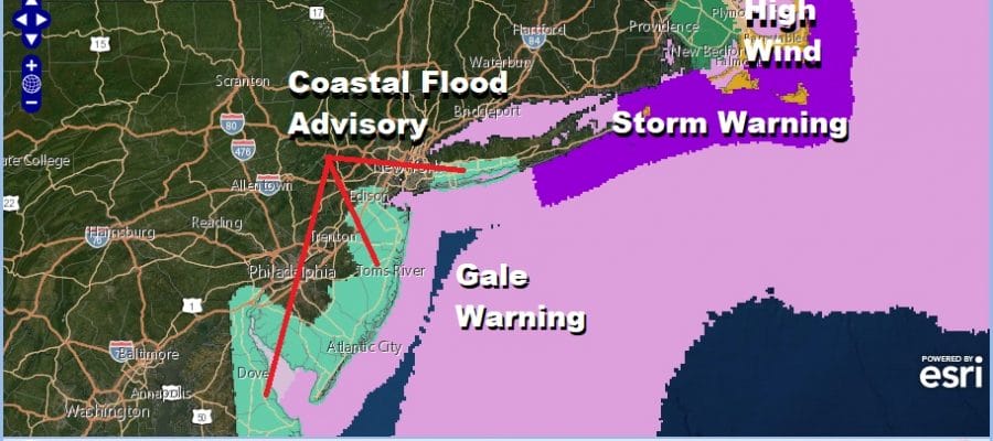
Coastal Flood Advisory Gale Warnings Coastal Storm Offshore Into Saturday
We have a coastal storm sitting to the southeast of NYC by about 300 miles or so and we are seeing the beginnings of wind and rain over some of the coastal areas to the east of NYC. Rain is backing in from the southeast and moving back westward. To the west of New Jersey we are seeing clouds and showers from the upper air storm that is driving the surface low track. In between some precipitation is showing up aloft. It is cloudy everywhere. As to the wind we are seeing some gusty winds over Long Island and Southeastern New England but elsewhere the wind has not quite picked up yet.
SATELLITE

REGIONAL RADAR

You can see the regional radar shows the gap in between the two rain areas. It is conceivable that some areas today will see very little rain. The main batch of rain and wind will come later tonight and during the day Thursday as the coastal storm moves back westward and does a counter clockwise loop to the southeast of us. Temperatures today are going no where with highs in the raw 50s.
LOCAL RADAR NEW YORK CITY

LOCAL RADAR PHILADELPHIA


Tonight and Thursday we will start to see winds increasing over coastal areas where winds over Eastern Long Island could eventually gust to 50 mph or more on Thursday while along the New Jersey shore 30 to 40 mph wind gusts are more likely.
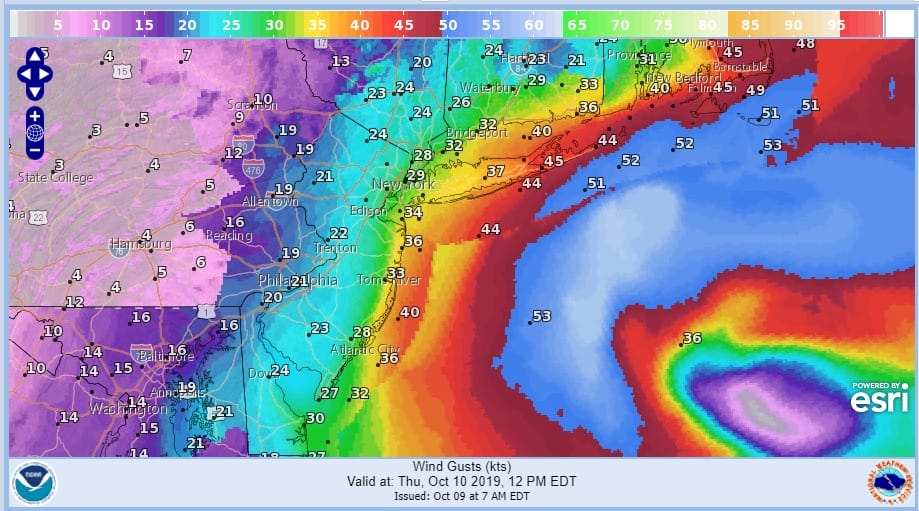
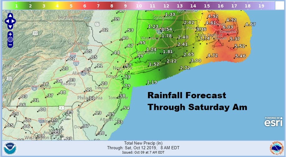
The main surge of rain comes late tonight and on Thursday but the heaviest rain will be east of New York City with 3 to 5 inch rains in Southeastern New England with 1 to 2 inches over Long Island. Amounts decrease rapidly over New Jersey and areas north, northwest, and southwest of New York City. With rain and wind temperatures will be in the low to mid 50s for highs while areas that get little or no rain we will see highs in the mid to upper 50s. Either way it is a raw ugly day.
The looping strong storm will begin to drop southward by Friday and then start to move out to the east on Saturday. This sets us up for several tide cycles where coastal flooding will be an issue. Fortunately we are not dealing with a landfall here as the low never crosses land. Nonetheless the fetch of wind from off the ocean will be producing minor to moderate coastal flooding beginning with the late day tide in coastal New Jersey and then with the Thursday high tides on Long Island and New Jersey.

For the coastal waters Storm Warnings are posted for the waters south of Southeastern Suffolk County eastward for Thursday. Gale Warnings are posted everywhere else. The storm finally begins to pull away on Saturday though we could still be in lots of clouds Saturday with highs reaching into the 60s. We should see some breaks of sunshine on Sunday with highs in the 60s to near 70.
MANY THANKS TO TROPICAL TIDBITS FOR THE USE OF MAPS
Please note that with regards to any severe weather, tropical storms, or hurricanes, should a storm be threatening, please consult your local National Weather Service office or your local government officials about what action you should be taking to protect life and property.


