Clouds Increasing Rain Arrives Monday
Clouds Increasing Rain Arrives Monday
It didn’t exactly turn out to be picture perfect today. The satellite loop shows lots of high clouds streaming eastward across Pennsylvania and that is filtering the sun this afternoon. There are even a few spot showers showing up on the local radars but this is all aloft and the dry air should keep this from reaching the ground. Temperatures are in the 70s to near 80. Humidity levels are low so at least it is comfortable out there. There should be no weather issues through tonight but there could be some rain arriving in Southeast Pennsylvania and Southern New Jersey late tonight. Everywhere else it should be dry but cloudy Monday morning.
SATELLITE LOOP

REGIONAL RADAR

LOCAL RADAR NEW YORK CITY

LOCAL RADAR PHILADELPHIA


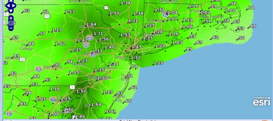
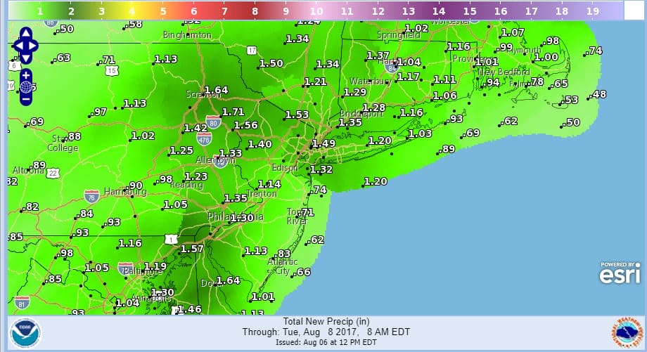
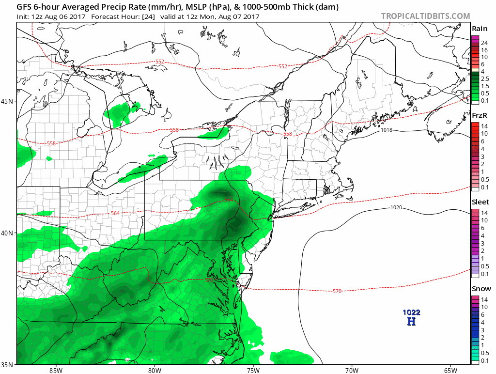
Monday we get rain and an ocean wind as low pressure develops to our south and passes off the New Jersey coast Monday night and then exits Tuesday morning. This looks like a widespread inch to an inch and a half of rain for everyone. Areas in South Jersey southward might be at risk for severe thunderstorms if the warm sector makes it that far north. Temperatures in many areas will settle in the 60s once the rain begins while areas well south could be in the 70s to near 80. Much of the area will have a cool autumn feel to it on Monday.
Tuesday Wednesday and probably Thursday should be decent days with sunshine and no rain threat. Temeratures this week will be on the cool side with highs in the upper 70s to lower 80s and nighttime lows in the 50s in areas north and west of the coast..and lower 60s along the coast and in warmer urban locations. No hot weather is in sight for the short range at least.
 GET JOE A CIGAR IF YOU LIKE

LANDSCAPE COMPANIES FOR YOUR NEEDS
LONG ISLAND ROCKLAND COUNTY Connecticut

![]()

ROCKLAND COUNTY TRI STATE SNOW REMOVAL JOHNSTOWN PA


FiOS1 News Weather Forecast For Long Island
FiOS1 News Weather Forecast For New Jersey
FiOS1 News Weather Forecast For Hudson Valley
NATIONAL WEATHER SERVICE SNOW FORECASTS
LATEST JOESTRADAMUS ON THE LONG RANGE
Weather App

Don’t be without Meteorologist Joe Cioffi’s weather app. It is really a meteorologist app because you get my forecasts and my analysis and not some automated computer generated forecast based on the GFS model. This is why your app forecast changes every 6 hours. It is model driven with no human input at all. It gives you an icon, a temperature and no insight whatsoever.
It is a complete weather app to suit your forecast needs. All the weather information you need is right on your phone. Android or I-phone, use it to keep track of all the latest weather information and forecasts. This weather app is also free of advertising so you don’t have to worry about security issues with your device. An accurate forecast and no worries that your device is being compromised.
Use it in conjunction with my website and my facebook and twitter and you have complete weather coverage of all the latest weather and the long range outlook. The website has been redone and upgraded. Its easy to use and everything is archived so you can see how well Joe does or doesn’t do when it comes to forecasts and outlooks.
Just click on the google play button or the apple store button on the sidebar for my app which is on My Weather Concierge. Download the app for free. Subscribe to my forecasts on an ad free environment for just 99 cents a month.
Get my forecasts in the palm of your hand for less than the cost of a cup of Joe!


