Clouds An Issue Today Rain South And East Offshore More Waves Ahead

Weather in 5/Joe & Joe Weather Show Latest Podcast
Clouds An Issue Today Rain South And East Offshore More Waves Ahead
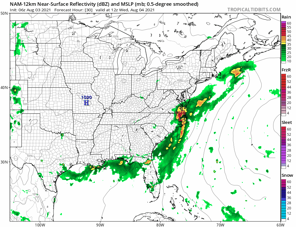
The stalled frontal boundary offshore lies from southeast of Cape Cod to the Carolinas. The front is beginning to buckle and the first of 3 waves is moving northeastward from the Carolinas. There will be an area of rain moving offshore from this first wave and the bulk of the area will miss the rain part but the satellite shows lots of high clouds have pushed northward into the Hudson Valley and Westward into Pennsylvania. Today obviously will not be as sunny as yesterday. In fact most of the area will see broken to overcast skies with just some breaks of sun in the mix possible. That will hold temperatures down and keep them mostly in the 70s this afternoon.
SATELLITE

WEATHER RADAR
The regional radar is picking up on the northern fringe of the rain from Southern New Jersey southward. The dry air overhead is drying up the northern fringe of this so that rain is mostly aloft and you have to head down to southern Virginia or even North Carolina to find anything substantial. Movement is to the northeast.


Once the first wave goes by this evening, skies may partially clear for awhile overnight with lows in the 60s in most places. Wednesday we will again be under clouds as a second wave moves up the coast. This one is going to be a little further to the west.
It appears that rain will move up the coast and impact coastal areas from New Jersey to Long Island and Southern New England but there will be a sharp western cut off to the rain so from Western New Jersey and points westward will just be in clouds. Temperatures Wednesday will be in the 70s.
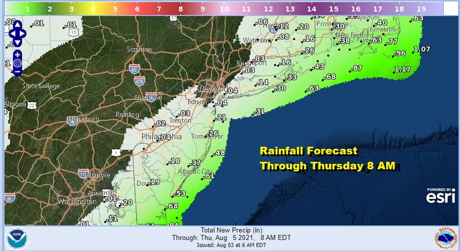
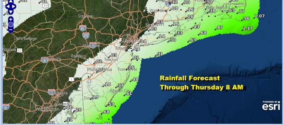
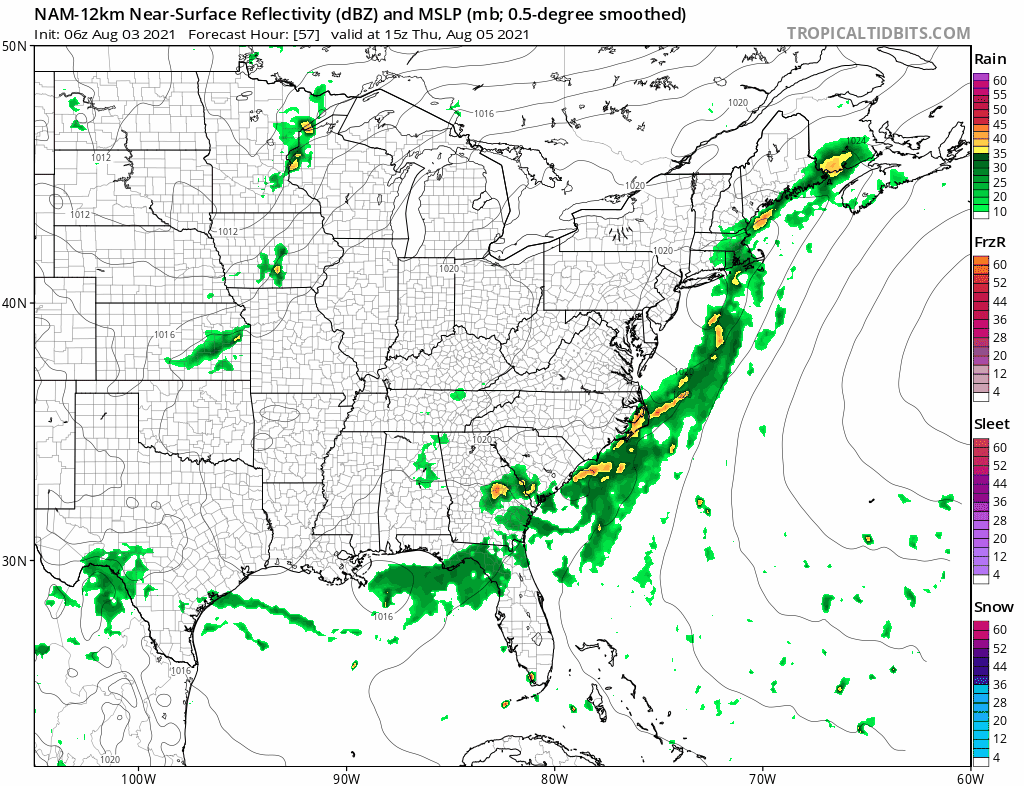
I don’t have issue with the western edge of the measurable rainfall through 8am Thursday but I think the amounts to the east are a bit too low. Either way this should pull out early Thursday morning. Then the next wave comes up the coast. Clouds will still be around Thursday with highs in the mid 70s coast to lower 80s inland. The rain from this wave now misses the area. Once that wave goes by Friday morning the ridge in the Atlantic builds back westward and the frontal boundary falls apart.
Clouds Friday will gradually give way to some sunshine but we will start to warm and more humid with highs reaching the mid to upper 80s. Saturday looks to be a very warm and humid one with some sunshine both Saturday and Sunday and we will throw in the chance for a downpour or a thunderstorm. Highs will be in the mid to upper 80s. A bit of a back door front comes through Saturday night leaving us warm and humid with more of an ocean wind Sunday. Highs Sunday will be in the middle to upper 80s well inland and upper 70s and lower 80s along coastal areas.
BE SURE TO DOWNLOAD THE FREE METEOROLOGIST JOE CIOFFI WEATHER APP &
ANGRY BEN’S FREE WEATHER APP “THE ANGRY WEATHERMAN!

MANY THANKS TO TROPICAL TIDBITS & F5 WEATHER FOR THE USE OF MAPS
Please note that with regards to any severe weather, tropical storms, or hurricanes, should a storm be threatening, please consult your local National Weather Service office or your local government officials about what action you should be taking to protect life and property.


