
Chance For Passing Showers Tuesday Precipitation Thursday Night Very Cold Friday Into Weekend
We finished up another nice day with sunshine and arriving high clouds. We have a cold front approaching and high pressure moving offshore so look for some clouds around tonight and it won’t be as cold with most lows overnight in the 40s. Some 30s are possible in cold spots where skies might be clear or at least partially clear for awhile. High clouds will be increasing overnight as the satellite loop shows and the front draws closer.
SATELLITE

REGIONAL RADAR

The moisture here i limited at the moment and we can see some patches of precipitation aloft on the regional and local radars but it is all aloft. Nothing is reaching the ground and we don’t expect anything overnight. There could be a few showers along the coast Tuesday morning as the front swings across Western Pennsylvania. Some rain showers there will likely dry up as they move east so for most tomorrow nothing more than a passing brief shower if at all. Temperatures will reach the upper 50s and lower 60s.
LOCAL RADAR NEW YORK CITY

LOCAL RADAR PHILADELPHIA


Wednesday brings another chilly air mass in for the day with some sunshine. Highs will be in the low to mid 50s. Then we begin to set up for a wave of low pressure on an approaching arctic boundary. Clouds will increase on Thursday. Highs will reach into the 50s in most places.

This situation for Thursday night is where we have cold air racing eastward with a cold front and a wave developing on that front. Most times the cold air doesn’t make to the coast in time and the precipitation falls mostly as rain before it just shuts off after the low goes by. That is how I am seeing this set up. This means rain for most of the area from Eastern Pennsylvania to Southern New England. If the cold air builds in a bit stronger it might bring that rain snow line you see on the loop further south to perhaps near route 84 but I think right now that would be the worst case scenario. This is all done by early Friday morning.
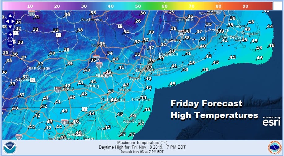
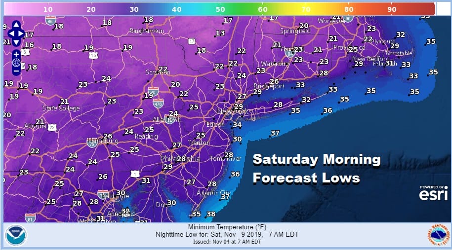
Friday brings in the coldest air of the season so far as high pressure builds in from the west. Temperatures Friday will be just in the upper 30s and lower 40s for daytime highs and we will be headed down into the 20s everywhere Friday night with teens in cold spots for Saturday morning.
The weekend looks uneventful with some sunshine but it will be cold on Saturday with highs just in the upper 30s and lower 40s. Sunday temperatures will bounce a bit higher with some sunshine. Highs will be in the 40s to near 50.
BE SURE TO DOWNLOAD THE FREE METEOROLOGIST JOE CIOFFI WEATHER APP &
ANGRY BEN’S FREE WEATHER APP “THE ANGRY WEATHERMAN!
MANY THANKS TO TROPICAL TIDBITS FOR THE USE OF MAPS
Please note that with regards to any severe weather, tropical storms, or hurricanes, should a storm be threatening, please consult your local National Weather Service office or your local government officials about what action you should be taking to protect life and property.


