Brutally Cold April Morning Models Back Off On Saturday Snow
Brutally Cold April Morning Models Back Off On Saturday Snow
It isn’t so much the temperatures outside this morning that are extreme as we are hitting bottom in the mid 20s to lower 30s, it is the ridiculous wind which continues to howl from the northwest at 20 to 30 mph with gusts to near 40 mph in some places so it feels like its in the teens. For early April where 60 degree highs should be common place this is really just a bit insane. However it is consistent with the pattern we have been in since the end of February so we have to just continue to ride it along. Reflexively we should be heading for 60 this afternoon. Instead we won’t see much above the mid 40s. If you want to seasonally adjust that, it would be like a day in January with temperatures not much above the mid 20s!
The satellite picture this morning shows cloud free skies along the coast but not that far north and west we have clouds and a very active lake effect snow machine that has been working overtime since yesterday afternoon. That should relax some today and other than passing clouds we have no serious concerns at all. At least the sun will feel good while that wind is busy making you wish for Florida.
US SATELLITE

REGIONAL RADAR

Tonight clouds are going to be moving in and we have the first of two weather systems in play. Yesterday this looked like a quick burst of snow Friday morning for inland areas and a rain or snow shower burst along the coast. I was thinking yesterday that a coating to an inch was possible in some areas and I still think that is the case. It is quick and lasts for a couple of hours and then melts almost immediately if not sooner.
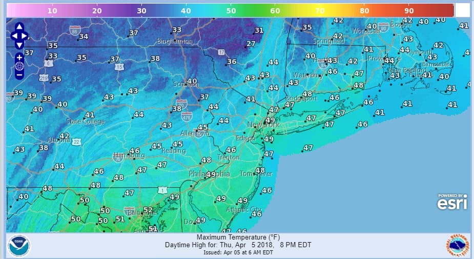
SNOW FORECAST FRIDAY MORNING APRIL 6, 2018

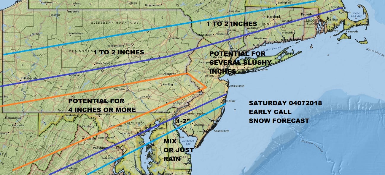
Once that moves out we will spend the rest of the day in clouds and the chance for a passing rain shower with highs reaching the upper 40s to mid 50s. Then a cold front passes and we wait for Saturday. Weather models overnight have backed WAY off on a wave of low pressure moving offshore as models have suppressed this system to the south. Snow makes it as far north as Central New Jersey and perhaps the south shore of Long Island and that’s it! Certainly this falls in the scope of possibilities. What it suggests is that cold air basically overwhelms everything (hard to imagine in April but it happens) with the upper flow remaining rather flat in nature. For the time being we are going to leave our original forecast alone for Saturday.
SATURDAY SNOW FORECAST APRIL 7, 2018
Let us see if this was a hiccup overnight or will this carry going forward? Perhaps it is something between. All of the weather models went this route further south overnight so it does have some weight. Again for now we will leave things alone and see what happens. Frankly I hope it doesn’t happen since the vast majority of you have had enough of all this (and I am part of that majority). We will be watching model runs very closely today to see if the trend continues.
 GET JOE A CIGAR IF YOU LIKE

FiOS1 News Weather Forecast For Long Island
FiOS1 News Weather Forecast For New Jersey
FiOS1 News Weather Forecast For Hudson Valley


