
Brutal Cold Beginning of 2018
Brutal Cold Beginning of 2018
Snow or no snow one thing is for sure no matter which model you look at. The beginning of the New Year is going to be very cold across much of the Eastern 2/3rds of the US and in some places it is going to be brutally cold especially across the South and especially on the European model (though it is on the GFS as well).
GFS FORECAST TEMPERATURES 7AM EASTERN TIME WEDNESDAY 12/27/2017

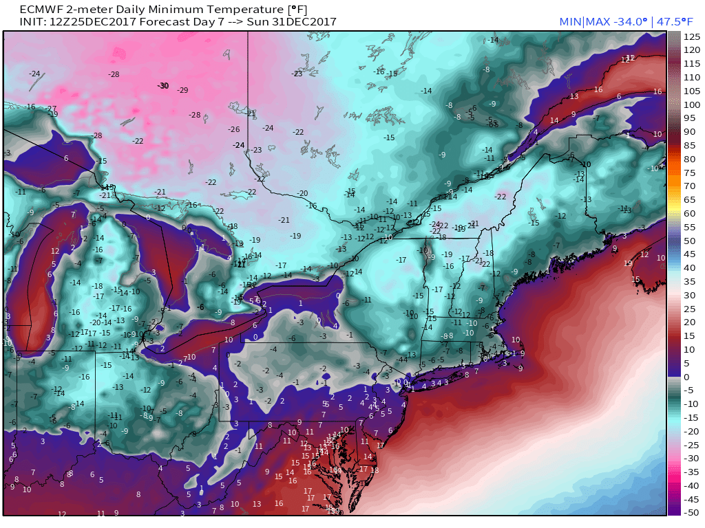
Beginning this Wednesday morning much of Upstate Northeastern New York and Central & Northern New England will see below zero low temperatures for at least 8 consecutive days. We have not seen cold like this since February 2015. The coldest stretch will start next Sunday New Years Eve and last into the first few days of the New Year. The European is also forecasting some snow here next Saturday night into Sunday and if that happens I think we could see a large portion of our area drop to below zero lows as well.
EUROPEAN FORECAST LOWS SUNDAY DECEMBER 31 MAP COURTESY OF WX.GRAPHICS
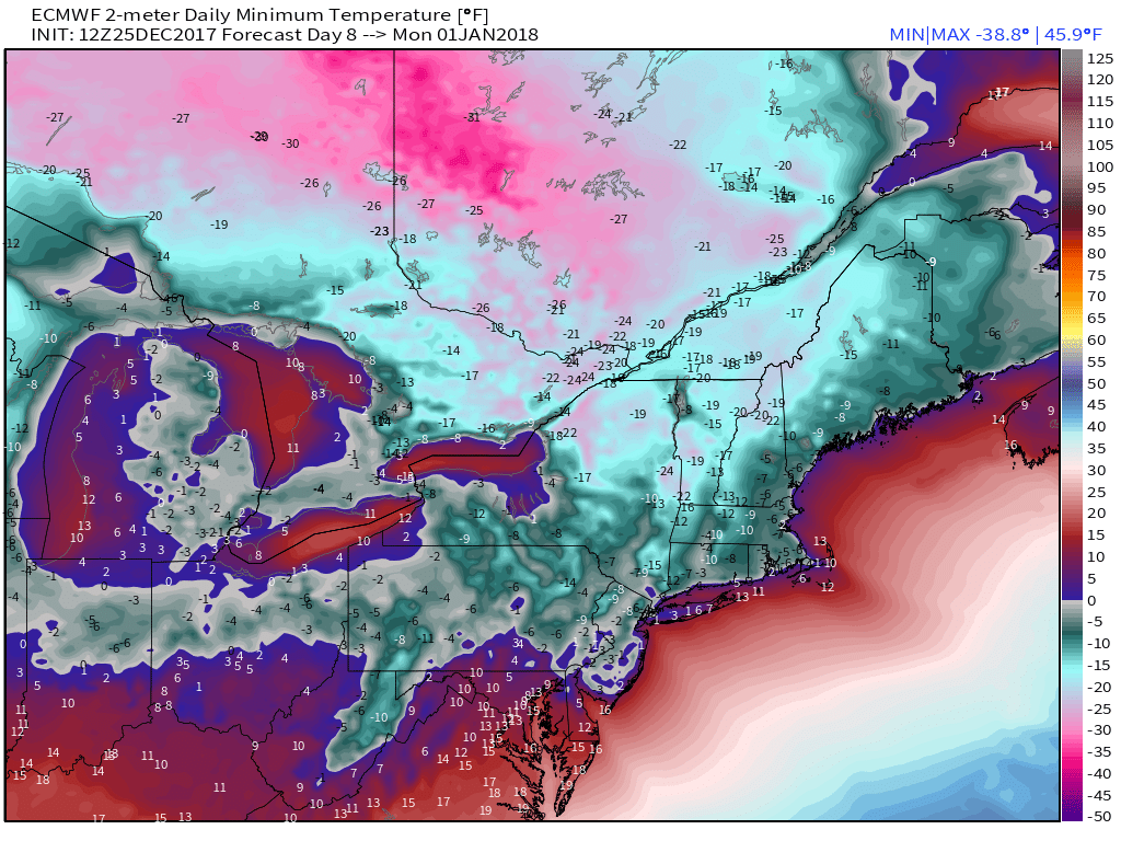
EUROPEAN FORECAST LOWS MONDAY JANUARY 1 2018 MAP COURTESY OF WX.GRAPHICS
Meanwhile it is cold and windy this afternoon as a storm intensifies in the Gulf of Maine and heads to Nova Scotia. The satellite loop shows the storm wrapping up and bringing blizzard conditions to parts of Maine and Nova Scotia. Winds are gusting over 40 mph at times here. Temperatures tonight will drop into the upper teens and lower 20s by morning. If we make it above 32 tomorrow don’t expect to see it again for at least the next 9 or 10 days.
SATELLITE LOOP

REGIONAL RADAR

Wednesday Thursday and Friday daytime highs probably won’t make it out of the 20s with nights in the single digits to mid teens in most places. Then comes the weekend where a snow threat is possible Saturday and Saturday night. The European model has a slightly different take on it than the GFS though both show some snow possible as the northern jet strengthens and a storm forms just offshore. It would be something like what happened last night except this time we would be much deeper into the cold air. In fact the European and the GFS would suggest snow events that would take us back to the ones we got in 2013-14 and 2014-15 where virtually every single snow fall in those winters occurred with temperatures in the teens and in some cases temperatures in the single digits. If we put a snow cover down be ready for brutually cold weather as 2018 arrives.
EUROPEAN FORECAST LOWS TUESDAY JANUARY 2 2018 MAP COURTESY OF WX.GRAPHICS
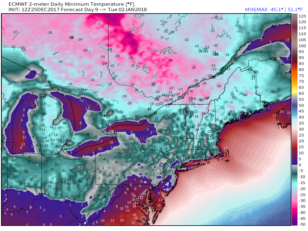
The extent of the cold air will be be as far south as Northern Florida and we could see areas across the Gulf States see days where daytime temperatures never get out of the 20s.
 GET JOE A CIGAR IF YOU LIKE

FiOS1 News Weather Forecast For Long Island
FiOS1 News Weather Forecast For New Jersey
FiOS1 News Weather Forecast For Hudson Valley


