Brief Summer Day Before Weekend Cool Air Arrives Marginal Severe Weather Risk

Brief Summer Day Before Weekend Cool Air Arrives Marginal Severe Weather Risk

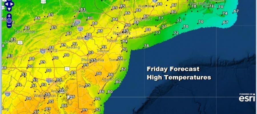
This time of year, even in a pattern where it is generally unfavorable for long duration heat and humidity (more than 3 days), you can sneak a hot day in every once in while and that is what we are seeing today. A cold front passed through last night but the real cold front actually comes through later today. Winds today will be from the west or northwest which means no sea breeze and the coast will be just as warm as inland areas. Highs this afternoon will reach the upper 80s to lower 90s in most places and note that areas to the south could see highs reaching the middle 90s.
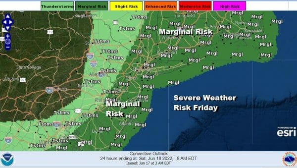
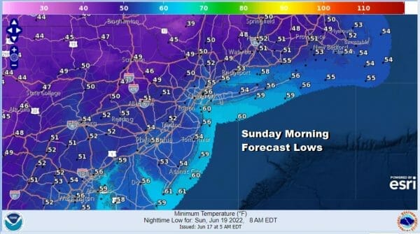
The satellite loop shows clouds with the second front approaching and it will likely reach the coast early this afternoon. I expect that there could be a very thin line of showers and thunderstorms when the front goes by and the Storm Prediction Center is indicating a marginal risk for severe weather today based on the overnight forecast. I’m not expecting much change in the outlook for today when the forecast is updated later this morning. Once the front passes the winds will turn more northwest and we will start to see a very cool flow of air begin from Canada. Skies will clear tonight with Saturday morning lows in the mid 50s to lower 60s.
SATELLITE

WEATHER RADAR

Saturday is going to be a reminder of what weather should be like in say early May. Low pressure will be sitting off the coast of Maine with a strong high over the Northern Great Lakes. The pressure gradient will be on the tight side and that means that we will see gusty winds Saturday of 20 to 30 mph or more at times. We will also see sunshine but there will be some patchy clouds developing from time to time especially inland north and northeast of coastal areas.

To me it is the high temperature forecast that stands out because we should be up into the lower 80s on a daily basis for this time of year and yet there will be many areas as the map indicates where highs won’t be getting out of the 60s! Most highs will average in the upper 60s to lower 70s or some 10 degrees below average. Saturday night will be quite cool with most lows under clear skies in the low to mid 50s.
There may be a few clouds to the east across Long Island and Southeastern New England Saturday night as a weak upper trough moves through but I’m not expecting anything else. Sunday we see a nice Father’s Day with plenty of sunshine. It will still be a bit on the breezy side though and highs Sunday will be in the low to middle 70s.

In some ways next week looks like a repeat of this past week. We will start off dry Monday as we will still be under the influence of the upper low to the northeast. Sunshine will take highs to the upper 70s and lower 80s. We will be looking for a chance for showers Tuesday as a system drops southward from Canada. Wednesday and Thursday look okay before another cold front arrives late next week. Beyond that models are hinting at a warmer pattern toward month end but there is a bit of uncertainty regarding the upper air pattern and whether the heat sets up to our west or does it move into the east. Enjoy your weekend.
BE SURE TO DOWNLOAD THE FREE METEOROLOGIST JOE CIOFFI WEATHER APP &
ANGRY BEN’S FREE WEATHER APP “THE ANGRY WEATHERMAN!
MANY THANKS TO TROPICAL TIDBITS & F5 WEATHER FOR THE USE OF MAPS
Please note that with regards to any severe weather, tropical storms, or hurricanes, should a storm be threatening, please consult your local National Weather Service office or your local government officials about what action you should be taking to protect life and property.


