Brief Noreaster Conditions Friday Night Saturday Morning Coast
Brief Noreaster Conditions Friday Night Saturday Morning Coast
Noreasters in July are a pretty rare thing and for a short time Friday night into Saturday morning we will probably see some gusty northeast winds along the coast as low pressure develops along the Delaware coast. It is almost like a winter time situation where we keep watching models for north south shifts from run to run. The European model was especially bullish for rain and a bit of wind. The rain begins Friday afternoon and ends Saturday morning with improving weather conditions Saturday afternoon.
BRIEF NOREASTER FRIDAY NIGHT SATURDAY MORNING
EUROPEAN MODEL 8AM SATURDAY

Other weather models have been going back and forth north vs south. I think as I have been saying for awhile that this will be a 1 to 2 inch rain producer for most. The northern extent of the rain will only get so far north into the Hudson Valley and Connecticut. Late Friday night early Saturday morning along the coast NE winds will be 20 to occasionally 30 knots with some higher gusts.
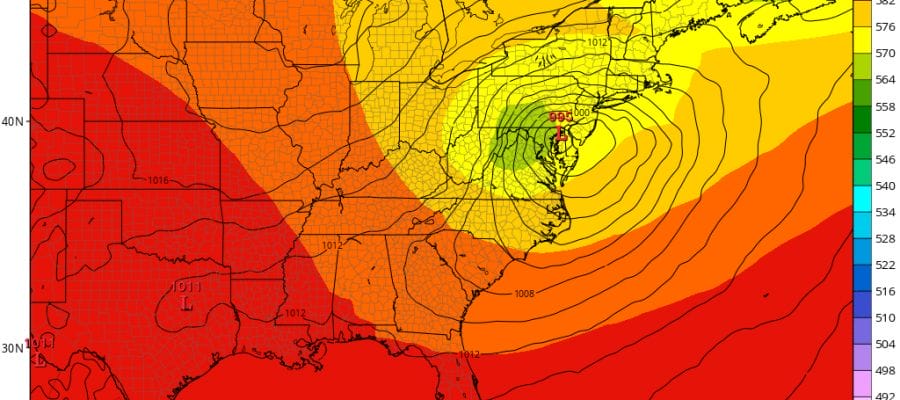
BRIEF NOREASTER CONDITIONS SATURDAY MORNING GFS MODEL
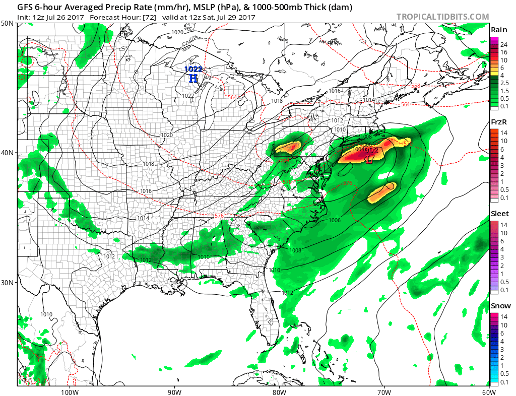
The GFS is a little flatter (weaker) and a bit faster than the European which would argue for improving weather conditions during Saturday while the European would probably suggest lots of clouds will linger into Saturday evening before weather conditions improve. The main difference in the two models is the strength of the upper air feature with the European so much deeper (stronger) than the GFS model. This issue will need to be resolved in order to be more specific with the final outcome. Either way Sunday looks good with mostly sunny skies and highs in the upper 70s to some lower 80s.
EUROPEAN UPPER AIR JET STREAM 8AM SATURDAY

SATELLITE LOOP

REGIONAL RADAR

Meanwhile it is a nice afternoon with sunshine and some clouds with most temperatures in the mid to upper 70s. Skies should be nice and clear tonight with lows in the 60s and 50s in cool spots. Thursday looks like sun mixing with arriving clouds. The Storm Prediction Center has a large part of our area at a slight risk of severe weather Thursday evening. Judging by the dynamics it seems a bit overstated to me at the moment….AT 5:30PM THE STORM PREDICTION CENTER REDUCED THE RISK.
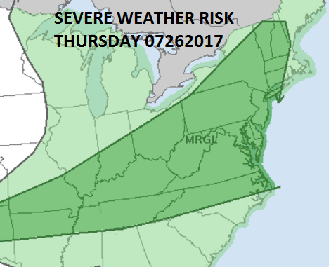
We will review the severe weather threat in greater detail later this evening.
 GET JOE A CIGAR IF YOU LIKE

LANDSCAPE COMPANIES FOR YOUR NEEDS
LONG ISLAND ROCKLAND COUNTY Connecticut

![]()

ROCKLAND COUNTY TRI STATE SNOW REMOVAL JOHNSTOWN PA


FiOS1 News Weather Forecast For Long Island
FiOS1 News Weather Forecast For New Jersey
FiOS1 News Weather Forecast For Hudson Valley
NATIONAL WEATHER SERVICE SNOW FORECASTS
LATEST JOESTRADAMUS ON THE LONG RANGE
Weather App

Don’t be without Meteorologist Joe Cioffi’s weather app. It is really a meteorologist app because you get my forecasts and my analysis and not some automated computer generated forecast based on the GFS model. This is why your app forecast changes every 6 hours. It is model driven with no human input at all. It gives you an icon, a temperature and no insight whatsoever.
It is a complete weather app to suit your forecast needs. All the weather information you need is right on your phone. Android or I-phone, use it to keep track of all the latest weather information and forecasts. This weather app is also free of advertising so you don’t have to worry about security issues with your device. An accurate forecast and no worries that your device is being compromised.
Use it in conjunction with my website and my facebook and twitter and you have complete weather coverage of all the latest weather and the long range outlook. The website has been redone and upgraded. Its easy to use and everything is archived so you can see how well Joe does or doesn’t do when it comes to forecasts and outlooks.
Just click on the google play button or the apple store button on the sidebar for my app which is on My Weather Concierge. Download the app for free. Subscribe to my forecasts on an ad free environment for just 99 cents a month.
Get my forecasts in the palm of your hand for less than the cost of a cup of Joe!


