
Noreaster Conditions Growing More Likely Coastal New Jersey Long Island
Noreaster Conditions Growing More Likely
Coastal New Jersey Long Island Friday Night Saturday AM
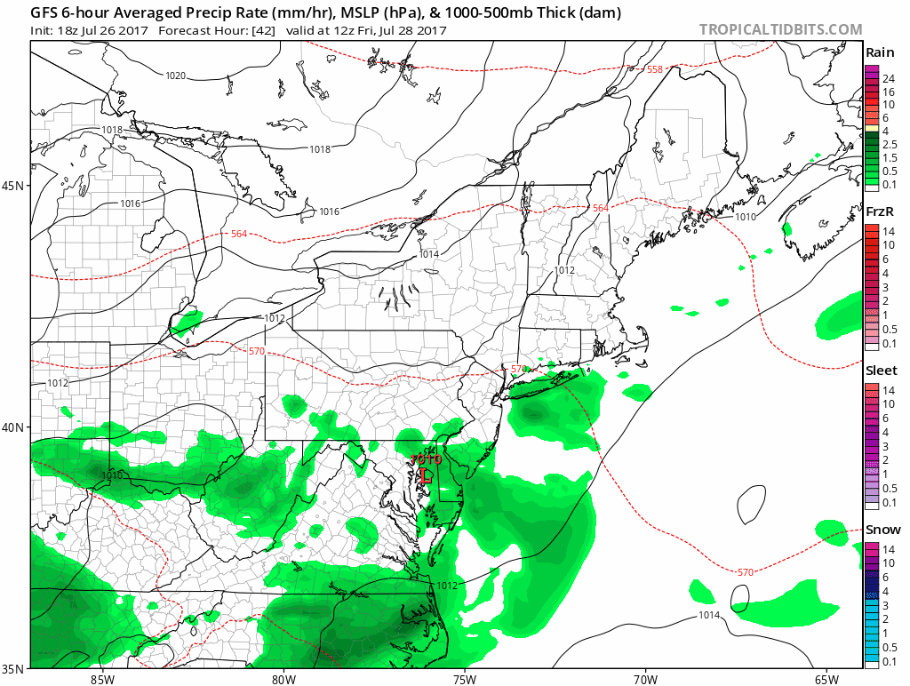
Weather models continue to hone in on a developing low along the Delaware Coast Friday night and this could be setting us up for a 12 hour wind and rain event for coastal areas of New Jersey & Long Island. Afternoon as well as late afternoon model runs are coming closer together on this idea. The European and NAM are especially bullish on this and even the late afternoon GFS has come on board with a slower more intense looking low. If this were winter time, the winter storm watches would be going up!
GFS MODEL FRIDAY MORNING INTO SATURDAY EVENING
NAM MODEL FRIDAY MORNING INTO SATURDAY AFTERNOON 2PM
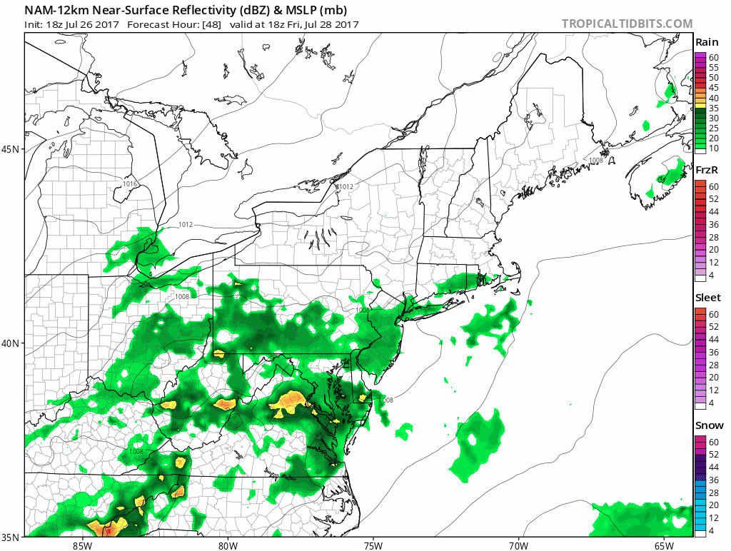
The late afternoon NAM & GFS model show the critical elements here in the track of the surface low just offshore. To see a low with pressures under 1000 millibars are unusual in July though not unheard of. Given the time of year the moisture field here is especially rich in subtropical moisture. Both models generate a core of very heavy rains on the order of 4 inches plus though the GFS has this area to the south and east of the coast while the NAM model takes it right overhead.
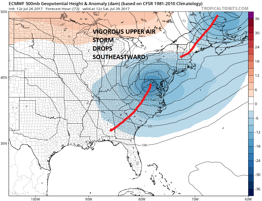
Key to all of this is this vigorous upper air trough and “cutoff” low that drops into Northern Virginia. The strength of this upper low and how long it holds together as it lifts out northeastward will determine whether this turns out to be a rain event of a couple of inches for somebody, or if it become something much more substantial. The European model above which is usually good with these sorts of systems is especially well developed. It doesn’t mean it is right but in the past it has handled these sorts of situations quite well so we need to pay attention here.
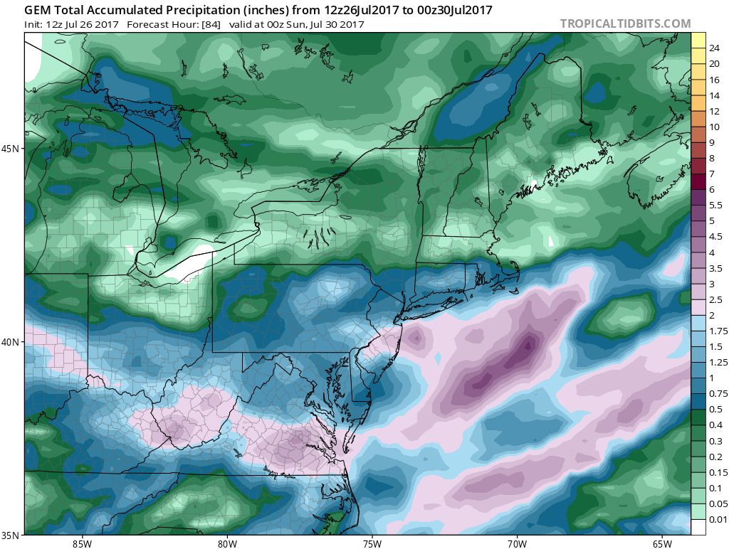
CANADIAN MODEL RAINFALL FORECAST THROUGH SATURDAY
GFS MODEL RAINFALL FORECAST THROUGH SATURDAY

NAM MODEL RAINFALL FORECAST THROUGH SATURDAY EVENING
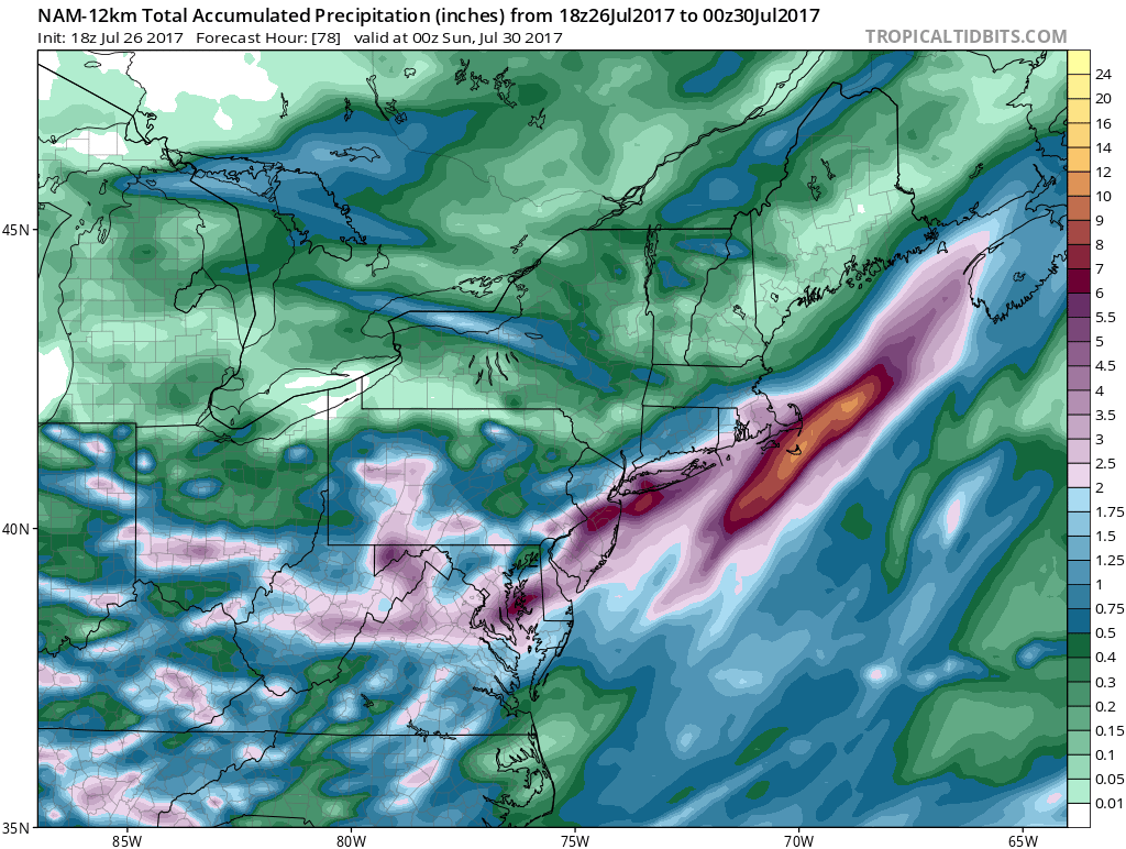
Above are the rainfall forecasts from the 3 major models. The Canadian & Gfs are similar with 1-2 inch rainfalls to about NYC & Long Island with 2 to 3 inches to the south across Central & Southern New Jersey. That area is saturated as it is from rains of the last couple of weeks. The NAM with its more intense features has double those amounts and actually produces some extreme numbers in a strip from Trenton to Sandy Hook to Long Island. All the models at least suggest that flash flood watches are likely to go up for Friday night into Saturday morning. All three models develop winds of 20 to 30 knots with higher gusts for the offshore waters. The immediate coastal areas could get windy for awhile Friday night into Saturday morning. Just like how we monitor models with winter storms we have seen models jog up and down back and forth over the last 2 days but the trend in general seems to be more robust and bullish with every run. Also notice the sharp cut off in the rain once you go north of New York City and that is a consideration here; that areas just north and west of the coast will get much less in terms of rainfall out of this.
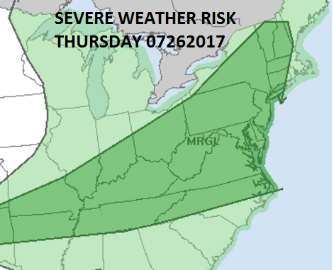
As far as the severe weather threat for Thursday, not surprisingly the Storm Prediction Center has reduced it to a marginal risk which makes more sense. The air over is is fairly dry and I don’t think it would saturate enough, nor do I believe the dynamics are there for any widespread outbreak of severe weather late tomorrow though there certainly could be a few scattered thunderstorms Thursday evening.
SATELLITE LOOP

REGIONAL RADAR

No weather issues for tonight other than a few passing clouds as indicated by the satellite loop. The radars are quiet and should be into Thursday afternoon for our area. Temperatures Thursday will be back into the 80s away from the ocean. Friday will depend on how fast we cloud up. If clouds are delayed it could reach the low 80s and then drop back into the 70s. Tonight into Saturday with this system revving up temperatures are likely to find their way back into the 60s again and they will stay there until weather conditions improve Saturday afternoon. No matter what happens Friday night and Saturday, Sunday will be mostly sunny with low humidity and highs in the upper 70s to lower 80s.
 GET JOE A CIGAR IF YOU LIKE

LANDSCAPE COMPANIES FOR YOUR NEEDS
LONG ISLAND ROCKLAND COUNTY Connecticut

![]()

ROCKLAND COUNTY TRI STATE SNOW REMOVAL JOHNSTOWN PA


FiOS1 News Weather Forecast For Long Island
FiOS1 News Weather Forecast For New Jersey
FiOS1 News Weather Forecast For Hudson Valley
NATIONAL WEATHER SERVICE SNOW FORECASTS
LATEST JOESTRADAMUS ON THE LONG RANGE
Weather App

Don’t be without Meteorologist Joe Cioffi’s weather app. It is really a meteorologist app because you get my forecasts and my analysis and not some automated computer generated forecast based on the GFS model. This is why your app forecast changes every 6 hours. It is model driven with no human input at all. It gives you an icon, a temperature and no insight whatsoever.
It is a complete weather app to suit your forecast needs. All the weather information you need is right on your phone. Android or I-phone, use it to keep track of all the latest weather information and forecasts. This weather app is also free of advertising so you don’t have to worry about security issues with your device. An accurate forecast and no worries that your device is being compromised.
Use it in conjunction with my website and my facebook and twitter and you have complete weather coverage of all the latest weather and the long range outlook. The website has been redone and upgraded. Its easy to use and everything is archived so you can see how well Joe does or doesn’t do when it comes to forecasts and outlooks.
Just click on the google play button or the apple store button on the sidebar for my app which is on My Weather Concierge. Download the app for free. Subscribe to my forecasts on an ad free environment for just 99 cents a month.
Get my forecasts in the palm of your hand for less than the cost of a cup of Joe!


